
Coffs Harbour is a city on the Mid North Coast of New South Wales, Australia, 540 km (340 mi) north of Sydney, and 390 km (240 mi) south of Brisbane. It is one of the largest urban centres on the North Coast, with an estimated population of 71,822 in 2018.

Grafton is a city in the Northern Rivers region of the Australian state of New South Wales. It is located on the Clarence River, approximately 608 kilometres (378 mi) by road north-northeast of the state capital Sydney. The closest major cities, Brisbane and the Gold Coast, are located across the border in South-East Queensland. At June 2018 Grafton had a population of 19,078. The city is the largest settlement and administrative centre of the Clarence Valley Council local government area, which is home to over 50,000 people in all.

The Pacific Highway is a 780-kilometre-long (485 mi) national highway and major transport route along the central east coast of Australia, with the majority of it being part of Australia's Highway 1. It no longer includes former sections of the highway between Brunswick Heads and Brisbane that have been legally renamed Pacific Motorway or Gold Coast Highway. As such, the highway stops short of the Queensland border near the Gold Coast.

Northern Rivers is the most north-easterly region of the Australian state of New South Wales, located between 590 kilometres (370 mi) and 820 kilometres (510 mi) north of the state capital, Sydney, and encompasses the catchments and fertile valleys of the Clarence, Richmond and Tweed rivers. It extends from Tweed Heads in the north to the southern extent of the Clarence river catchment which lies between Grafton and Coffs Harbour, and includes the main towns of Tweed Heads, Byron Bay, Ballina, Kyogle, Lismore, Casino and Grafton. At its most northern point, the region is 102 kilometres (63 mi) south south–east of the Queensland capital, Brisbane.

Macksville is a small town on the Nambucca River in the Nambucca Valley, New South Wales, Australia. It is halfway between Sydney and Brisbane, along the Pacific Highway, approximately 40 minutes north of Kempsey, 40 minutes south of Coffs Harbour, 1 hour 10 minutes north of Port Macquarie, 5 hours south of Brisbane and 5 hours north of Sydney.

Nambucca Valley Council is a local government area in the mid north coast region of New South Wales, Australia.

The Division of Cowper is an Australian electoral division in the state of New South Wales.

Bowraville is a small town in the Mid North Coast hinterland of New South Wales, Australia in the Nambucca Valley. The town is known for tourism with attractions such as a folk museum, a war museum, a historic theatre, and other historic buildings.

Nambucca River, an open and trained mature wave dominated barrier estuary, is located in the Mid North Coast region of New South Wales, Australia.
Yamba is a locality in northern New South Wales, Australia at the mouth of the Clarence River. The first European to visit the area was Matthew Flinders, who stopped in Yamba Bay for six days in July 1799.

The North Coast Line is the primary rail route in the Mid North Coast and Northern Rivers regions of New South Wales, Australia, and forms a major part of the Sydney–Brisbane rail corridor.
Eungai is a town on the mid-North Coast of New South Wales, Australia. It is made up of two localities, Eungai Creek and Eungai Rail, although both have the same postcode. The Eungai district is midway between Sydney (500 km) and Brisbane, midway between Port Macquarie (90 km) and Coffs Harbour, and midway between Kempsey (20 km) and Macksville. It is in the Nambucca Valley.

Woolgoolga is a town on the Mid North Coast of New South Wales, Australia. It is on the Pacific Highway, approximately 550 km north of Sydney and 365 km south of Brisbane. The closest city to Woolgoolga is Coffs Harbour, which lies 25.8 km to the south. Woolgoolga has two beaches on the Pacific Ocean. The area has long been a centre of banana growing in New South Wales, but this industry has declined in the face of competition from Queensland. Recent times have seen many banana plantations replaced by blueberries after banana sales slumped in the late 1990s. Timbergetting and sawmilling was established in 1883. A government jetty was constructed in 1892 upon which tramways were laid. These tramways led to sawmills in the town which in turn were connected by light railway to the Jesse Simpson Range forest areas. The jetty was demolished over a prolonged period from 1952 to 1956.

Scotts Head is a coastal village of the Nambucca Valley local government area in the Mid North Coast region of New South Wales, Australia. Located on the coast of the Pacific Ocean, approximately 10 kilometres (6 mi) from the Pacific Highway and 480 kilometres (300 mi) from Sydney, it stretches southwards from just south of the mouth of the Nambucca River to the town of Scotts Head in the south.
Gumbaynggir are an Australian Aboriginal group on the Mid North Coast of New South Wales. The Gumbaynggirr Nation is from Tabbimoble Yamba- Clarence River to Ngambaa-Stuarts Point, SWR- Macleay. The Gumbaynggirr have the largest midden-shell deposit in the Southern Hemisphere.

King Brothers was an Australian bus company operating route and school services in the Great Lakes and Mid North Coast regions of New South Wales. It collapsed in April 2003 with debts of $220 million, after owners Peter and Tony King were charged with and later convicted of fraud.
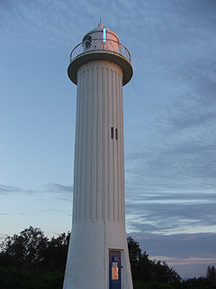
Nambucca Heads railway station is located on the North Coast line in New South Wales, Australia. It serves the town of Nambucca Heads, opening on 3 December 1923 as Nambucca Heads. It was renamed Nambucca in October 1925, before resuming its original name on 21 June 1964.

Oxley is an electoral district of the Legislative Assembly in the Australian state of New South Wales.
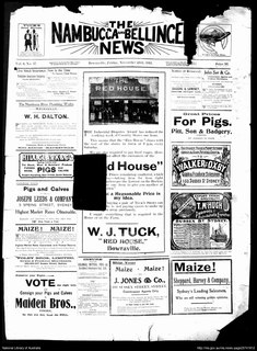
The Nambucca and Bellinger News was a weekly English language newspaper published in Bowraville in the Nambucca Shire of New South Wales, Australia from 1911-1945. It was also published as Nambucca News: Bellingen Chronicle,The Nambucca District News,The Nambucca Guardian News,Guardian Gazette and TheNambucca Valley Guardian News.
Giinagay Way is a road in the Mid North Coast region of New South Wales linking the towns of Warrell Creek, Macksville, Nambucca Heads and Urunga to Pacific Highway. It runs along a former section of the highway between Eungai Creek and Raleigh that was bypassed by a new parallel alignment between 2016 and 2018.


