

The following outline is provided as an overview of and topical guide to Zambia:
Contents
- General reference
- Geography of Zambia
- Environment of Zambia
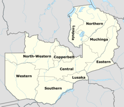
- Regions of Zambia
- Demography of Zambia
- Government and politics of Zambia
- Branches of the government of Zambia
- Foreign relations of Zambia
- Law and order in Zambia
- Military of Zambia
- Local government in Zambia
- History of Zambia
- Archaeological sites
- Disasters
- Topic
- Culture of Zambia
- Art in Zambia
- Languages of Zambia
- People of Zambia
- Specific Zambians
- Religion
- Sport in Zambia
- Economy and infrastructure of Zambia
- Education in Zambia
- See also
- References
- External links
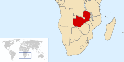
Zambia – landlocked sovereign country located in Southern Africa. [1] Zambia has been inhabited for thousands of years by hunter-gatherers and migrating tribes. After sporadic visits by European explorers starting in the 18th century, Zambia was gradually claimed and occupied by the British as protectorate of Northern Rhodesia towards the end of the nineteenth century. On 24 October 1964, the protectorate gained independence with the new name of Zambia, derived from the Zambezi river which flows through the country. After independence the country moved towards a system of one party rule with Kenneth Kaunda as president. Kaunda dominated Zambian politics until multiparty elections were held in 1991.[ citation needed ]