Planning areas of Singapore

Last updated
Planning areas of Singapore
Singapore MP2008. Urban Planning Areas.svg
CategoryFirst-level census division
Location Republic of Singapore
Created by Urban Redevelopment Authority
Created
  • September 1991 (proposed) [1]
  • 22 January 1999 (gazetted) [2]
Number55 (as of 2019)
Populations10 (Western Islands and Tengah, Singapore) – 281,300 (Bedok) [3] [4]
Areas0.77 km2 (0.30 sq mi) (Straits View) – 69.46 km2 (26.82 sq mi) (Western Water Catchment) [4]
Government
Subdivisions
  • Subzone

Planning areas, also known as DGP areas or DGP zones, are the main urban planning and census divisions of Singapore delineated by the Urban Redevelopment Authority. There are a total of 55 of these areas, organised into five regions. A Development Guide Plan is then drawn up for each planning area, providing for detailed planning guidelines for every individual plot of land throughout the country. [2]

Contents

The planning areas were first introduced in the early 1990s after the release of the 1991 Concept Plan. [5] Since the implementation of these boundaries, other government ministries and departments have also increasingly adopted these boundaries for their administrative purposes. For example, the Statistics Department of Singapore published its 2000 census data based on planning area boundaries for the first time, compared to using census divisions based on electoral boundaries for previous exercises. [6] The Singapore Police Force's (SPF) neighbourhood police centres have jurisdiction boundaries based on planning area boundaries when they were officially gazetted in 1999, as opposed to electoral divisions under the previous neighbourhood Police Post system.

List of planning areas

Inset map of the Central Area Map of Central Region, Singapore Planning Areas (+Central Area PAs).svg
Inset map of the Central Area

Planning areas are further subdivided into 332 subzones for statistical purposes. [3] [4]

Reference map for the planning areas of Singapore
Name (English) Malay Chinese Pinyin Tamil RegionArea (km²)Population [7] Density (/km²)
Ang Mo Kio 宏茂桥Hóngmàoqiáoஆங் மோ கியோ North-East 13.94161,00013,400
Bedok *勿洛Wùluòபிடோக் East 21.69278,27013,000
Bishan 碧山Bìshānபீஷான் Central 7.6285,68012,000
Boon Lay 文礼Wénlǐபூன் லே West 8.23303.6
Bukit Batok *武吉巴督Wǔjí Bādūபுக்கிட் பாத்தோக் West 11.13164,56014,000
Bukit Merah *红山Hóngshānபுக்கிட் மேரா Central 14.34149,16011,000
Bukit Panjang *武吉班让Wǔjí Bānràngபுக்கிட் பாஞ்சாங் West 8.99137,02015,000
Bukit Timah *武吉知马Wǔjí Zhīmǎபுக்கிட் திமா Central 17.5379,2704,400
Central Water Catchment Kawasan Tadahan Air Tengah中央集水区Zhōngyāng Jíshuǐqūமத்திய நீர் நீர்ப்பிடிப்பு North 37.15**
Changi *樟宜Zhāngyíசாங்கி East 40.611,81080.62
Changi Bay Teluk Changi樟宜湾Zhāngyí Wānசாங்கி பே East 1.7**
Choa Chu Kang 蔡厝港Cài Cuògǎngசுவா சூ காங் West 6.11189,99030,000
Clementi 金文泰Jīnwéntàiகிளிமெண்டி West 9.4993,5009,800
Downtown Core Pusat Bandar市中心Shìzhōngxīnசிங்கப்பூர் நகர மையத்தில் Central 4.344,000680
Geylang *芽笼Yálóngகேலாங் Central 9.64109,15011,400
Hougang 后港Hòugǎngஹவ்காங் North-East 13.93226,99016,000
Jurong East Jurong Timur裕廊东Yùláng Dōngஜூரோங் கிழக்கு West 17.8376,3904,400
Jurong West Jurong Barat裕廊西Yùláng Xīஜூரோங் மேற்கு West 14.69258,24018,000
Kallang *加冷Jiālěngகாலாங் Central 9.17100,52011,000
Lim Chu Kang 林厝港Lín Cuògǎngலிம் சூ காங் North 17.3905.2
Mandai *万礼Wànlǐமண்டாய் North 11.772,090180.2
Marina East Marina Timur滨海东Bīnhǎi Dōngமெரினா கிழக்கு Central 1.82**
Marina South Marina Selatan滨海南Bīnhǎi Nánமெரினா தென் Central 1.62**
Marine Parade 马林百列Mǎlín Bǎilièமரின் பரேட் Central 6.1245,8508,000
Museum Muzium博物馆Bówùguǎnஅருங்காட்சியகம் Central 0.83630480
Newton 纽顿Niǔdùnநியூட்டன் Central 2.079,0303,800
North-Eastern Islands Kepulauan Timur Laut东北群岛Dōngběi Qúndǎoவடகிழக்கு தீவுகள் North-East 42.88401.2
Novena 诺维娜Nuòwéinàநொவீனா Central 8.9850,5805,600
Orchard 乌节Wūjiéஆர்ச்சர்ட் Central 0.961,090960.3
Outram 欧南Ōunánஊட்ரம் Central 1.3717,46013,500
Pasir Ris *巴西立Bāxīlìபாசிர் ரிஸ் East 15.02145,9909,600
Paya Lebar *巴耶利峇Bāyé Lìbāபாய லேபார் East 11.69303.4
Pioneer 先驱Xiānqūபயனியர் West 12.1508.3
Punggol *榜鹅Bǎng'éபொங்கோல் North-East 9.34185,81017,800
Queenstown 女皇镇Nǚhuángzhènகுவீன்ஸ்டவுன் Central 20.4396,7304,400
River Valley 里峇峇利Lǐbā Bālìநதி பள்ளத்தாக்கு Central 1.4811,2506,800
Rochor 梧槽Wúcáoரோச்சோர் Central 1.6212,9308,300
Seletar *实里达Shílǐdáசிலேத்தார் North-East 10.2530026.3
Sembawang *三巴旺Sānbāwàngசெம்பவாங் North 12.34108,2208,400
Sengkang 盛港Shènggǎngசெங்காங் North-East 10.59252,73023,000
Serangoon *实龙岗Shílónggǎngசிராங்கூன் North-East 10.1117,91011,500
Simpang *新邦Xīnbāngசிம்பாங் North 5.13**
Singapore River Sungai Singapura新加坡河Xīnjiāpō Héசிங்கப்பூர் நதி Central 0.963,7403,000
Southern Islands Kepulauan Selatan南部群岛Nánbù Qúndǎoதெற்கு தீவுகள் Central 6.072,220244
Straits View Pemandangan Selat海峡景Hǎixiájǐngஸ்ட்ரெய்ட்ஸ் காண்க Central 0.77**
Sungei Kadut Sungai Kadut双溪加株Shuāngxī Jiāzhūசுங்கை காடுட் North 15.9974053.2
Tampines *淡滨尼Dànbīnníதெம்பினிஸ் East 20.89265,34012,400
Tanglin 东陵Dōnglíngடங்லின் Central 7.6322,9702,800
Tengah *登加Dēngjiāதெங்கா West 7.4101.4
Toa Payoh 大巴窑Dàbāyáoதோ பாயோ Central 8.17128,45014,300
Tuas *大士Dàshìதுவாஸ் West 30.04402.3
Western Islands Kepulauan Barat西部群岛Xībù Qúndǎoமேற்கத்திய தீவுகள் West 39.47100.25
Western Water Catchment Kawasan Tadahan Air Barat西部集水区Xībù Jíshuǐqūமேற்கத்திய நீர் நீர்ப்பிடிப்பு West 69.4661013
Woodlands 兀兰Wùlánஊட்லண்ட்ஸ் North 13.59252,19018,700
Yishun 义顺Yìshùnயீஷூன் North 21.24222,58010,100

* = Place names attested to be of Malay origin and referred to similarly in the Malay language.

See also

Related Research Articles

<span class="mw-page-title-main">Demographics of Singapore</span>

As of June 2023, the population of Singapore stands at 5.92 million. Of these 5.92 million people, 4.15 million are residents, consisting of 3.61 million citizens and 540,000 permanent residents (PRs). The remaining 1.77 million people living in Singapore are classed as non-residents, a group consisting mainly of foreign students and individuals on work passes.

A census tract, census area, census district or meshblock is a geographic region defined for the purpose of taking a census. Sometimes these coincide with the limits of cities, towns or other administrative areas and several tracts commonly exist within a county. In unincorporated areas of the United States these are often arbitrary, except for coinciding with political lines.

<span class="mw-page-title-main">Subdivisions of Scotland</span> Present or former administrative subdivisions of Scotland

For local government purposes, Scotland is divided into 32 areas designated as "council areas", which are all governed by single-tier authorities designated as "councils". They have the option under the Local Government (Scotland) Act 1997 of being known as a "comhairle" when opting for a Gaelic name; only Comhairle nan Eilean Siar has chosen this option, whereas the Highland Council has adopted its Gaelic form alongside its English equivalent, informally.

<span class="mw-page-title-main">Census geographic units of Canada</span> Term used in Canada

The census geographic units of Canada are the census subdivisions defined and used by Canada's federal government statistics bureau Statistics Canada to conduct the country's quinquennial census. These areas exist solely for the purposes of statistical analysis and presentation; they have no government of their own. They exist on four levels: the top-level (first-level) divisions are Canada's provinces and territories; these are divided into second-level census divisions, which in turn are divided into third-level census subdivisions and fourth-level dissemination areas.

<span class="mw-page-title-main">Urban area</span> Human settlement with high population density and infrastructure of built environment

An urban area, built-up area or urban agglomeration is a human settlement with a high population density and an infrastructure of built environment. This is the core of a metropolitan statistical area in the United States, if it contains a population of more than 50,000.

<span class="mw-page-title-main">Geylang</span> Planning Area and HDB town in Central Region, Singapore

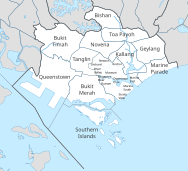
Geylang is a planning area and township located on the eastern fringe of the Central Region of Singapore, bordering Hougang and Toa Payoh in the north, Marine Parade in the south, Bedok in the east, and Kallang in the west.

<span class="mw-page-title-main">Kallang</span> Planning Area and HDB Town in Central Region ----, Singapore

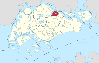
Kallang is a planning area and residential zone located in the Central Region of Singapore.

<span class="mw-page-title-main">Geography of Singapore</span>

Singapore is an island city-state and country in maritime Southeast Asia, located at the end of the Malayan Peninsula between Malaysia and Indonesia as well as the Straits of Malacca and the South China Sea. It is heavily compact and urbanised. As of 2023, Singapore has a total land area of 734.3 square kilometres (283.5 sq mi). Singapore is separated from Indonesia by the Singapore Strait and from Malaysia by the Straits of Johor.

<span class="mw-page-title-main">Tampines</span> Planning area and regional centre in East Region, Singapore

Tampines is the regional centre of the East Region of Singapore. With a population of 265,340 living across its five subzones, it is the second-most populous planning area in Singapore, according to the DOS Population Trends 2022. It is home to approximately 5% of Singapore's population. Tampines is bordered to the west by Bedok and Paya Lebar, to the north by Pasir Ris, to the east by Changi, and to the south by the Straits of Singapore. Situated in the historical region of Tanah Merah, its present-day terrain is particularly flat due to the large-scale sand quarrying in the 1960s.

<span class="mw-page-title-main">Seletar</span> Planning Area and Regional Centre in North-East Region ----, Singapore

Seletar is an area located in the north-east of Singapore. Its name can also refer to the Seletar Planning Area, situated in the North-East Region of Singapore. The place name was derived from the Malay subgroup who were indigenous to the area, the Orang Seletar. It shares boundaries with the planning areas of Sengkang to the south, Punggol to the east, Yishun and Simpang to the west, as well as the Straits of Johor to the north.

<span class="mw-page-title-main">Administrative divisions of Singapore</span> Ways Singapore has been subdivided for administrative purposes

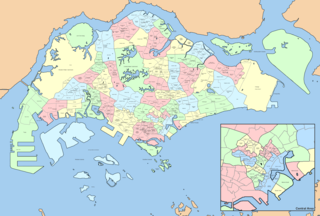
Singapore is governed as a unitary state without provinces or states. However, for the purposes of administration and urban planning, it has been subdivided in various ways throughout its history.

<span class="mw-page-title-main">Regions of Singapore</span> Subdivisions in the country of Singapore

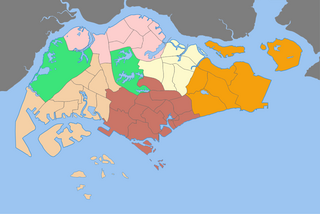
The regions of Singapore are urban planning subdivisions demarcated by the Urban Redevelopment Authority of Singapore to aid in its planning efforts. Over time, other governmental organisations have also adopted the five regions in their administrative work, as for example the Department of Statistics in the census of 2000. The regions are further subdivided into 55 planning areas, which include two water-catchment areas. The largest region in terms of area is the West Region with 201.3 km2 (77.7 sq mi), while the Central Region is the most populous with an estimated population of 922,980 inhabitants in the area in 2019.

<span class="mw-page-title-main">Neighbourhood police centre</span>

A neighbourhood police centre (NPC) is a small to mid-sized police station commonly found in Singapore. It was first introduced during the mid-1990s.

<span class="mw-page-title-main">Electoral division (Ireland)</span> Statistical division in Ireland

An electoral division is a legally defined administrative area in the Republic of Ireland, generally comprising multiple townlands, and formerly a subdivision of urban and rural districts. Until 1996, EDs were known as district electoral divisions in the 29 county council areas and wards in the five county boroughs. Until 1972, DEDs also existed in Northern Ireland. The predecessor poor law electoral divisions were introduced throughout the island of Ireland in the 1830s. The divisions were used as local-government electoral areas until 1919 in what is now the Republic and until 1972 in Northern Ireland.

Preston is a city of Lancashire, England. The districts of Preston vary in size and shape, many of which reflect the districts developed from former villages and boroughs which now lie within the boundaries of the city of Preston. Districts of Preston have little administrative purpose: for local elections voters in each return either two, or three, councillors to Town Hall. For the purposes of national General elections, the parliamentary constituencies representing the city use the electoral districts as "building bricks"

<span class="mw-page-title-main">Geylang Bahru</span> Subzone of Kallang Planning Area in Central Region, Singapore

Geylang Bahru is a subzone within the planning area of Kallang, Singapore, as defined by the Urban Redevelopment Authority (URA). It is bounded by the Pan Island Expressway (PIE) in the east; the Pelton Canal in the south; the Kallang River in the west; and Serangoon Road in the north.

Winnipeg, Manitoba, is subdivided in different ways for different purposes. The suburbs and neighbourhoods of Winnipeg take their names from former administrative districts, parishes, and geographic features.

References

  1. "HistorySG - 1991 Concept Plan is unveiled". National Library Board.
  2. 1 2 "Singapore Infopedia - Development guide plan". National Library Board.
  3. 1 2 "Statistics Singapore - Geographic Distribution - 2018 Latest Data" . Retrieved February 11, 2019.
  4. 1 2 3 City Population - statistics, maps and charts | SINGAPORE: Subdivision
  5. "Urban Redevelopment Authourity". Archived from the original on 2007-06-12. Retrieved 2007-06-02.
  6. Arumainathan, P. (1970). REPORT ON THE CENSUS OF POPULATION 1970 SINGAPORE - Volume II. Singapore Department of Statistics.
  7. "Population Trends 2022". Department of Statistics Singapore. June 2021. p. 202.