Weston is a village in the civil parish of Welford in the English county of Berkshire.

Great Alne is a small village in Warwickshire, England, 7 miles (11 km) north-west of Stratford-upon-Avon, 3 miles (4.8 km) north-east of Alcester and 15 miles (24 km) from Warwick, on the road to Wootton Wawen. It takes its name from the River Alne and was first chronicled in the charter of King Ethelbald (723–737). In 1969 Warwickshire County Council designated part of Great Alne as a Conservation Area, including most of the village east of the Memorial Hall and twelve listed buildings of local architectural and historical value. At the 2001 Census the population was 587.

Ashperton is a small village, parish and former manor about twelve miles east of the City of Hereford, in Herefordshire, England. The village is on the A417 road, the route of a Roman road from the City of Gloucester, in rolling countryside. Villages nearby include Monkhide, Tarrington and Canon Frome.

Stonton Wyville is a small village and civil parish in the Harborough district of Leicestershire, England. According to the 2001 census the parish had a population of 21. The population at the 2011 census remained fewer than 100 and was included in the civil parish of Glooston. The village is about eleven miles (17 km) south east of Leicester. Nearby places include Kibworth Harcourt, Tur Langton, Church Langton, and Shangton.
Alkmonton is a village and civil parish in the Derbyshire Dales district of Derbyshire, England, roughly between Uttoxeter and Derby. The parish had a population of 75 at the 2001 census and it remained less than 100 in 2011. Details are included in the civil parish of Cubley, Derbyshire.

Bearley is a village and civil parish in the Stratford-on-Avon district of Warwickshire, England. The village is about five miles (8 km) north of Stratford-upon-Avon, bounded on the north by Wootton Wawen, on the east by Snitterfield, and on the south and west by Aston Cantlow. The western boundary is formed by a stream running out of Edstone Lake; it would seem that the land, now part of Edstone in Wootton Wawen, between the stream where it flows west from the lake and the road running east from Bearley Cross, was originally included in Bearley. The land within the parish rises gradually from a height of 216 ft (66 m), in the north-west at Bearley Cross, to about 370 ft (110 m), at the south-east corner of the parish, and is open except along its eastern boundary, where part of the extensive wood known as Snitterfield Bushes is included in Bearley.

Stebbing is a small village in the Uttlesford district of northern Essex, England. The village is situated north of the ancient Roman road Stane Street. It is 6 miles (9.7 km) from the nearest railway station (Braintree), and 8 mi (13 km) from nearest airport. The village has a pub and a bowling green and had a population of 1,300 in 2011 census.

Spernall is a remote village 4 miles (6.4 km) north of Alcester in the parish of Oldberrow, Morton Bagot, and Spernall, in the Stratford-on-Avon District of Warwickshire, England. In the 2001 Census it had a population of 153. It is situated on the banks of the small River Arrow, the name meaning Spera's border. Early forms of the name are Spernore. and Spernoure in the 1327 Subsidy Roll. The village consists only of the church and rectory and a few scattered farms and cottages. At some time between 1195 and 1361 the parish was largely depopulated by pestilence, so that many of the villein tenements, which had hitherto accounted for almost the whole population, came into the hands of freemen. This may well refer to the Black Death; the priest at Spernall, Nicholas atte Yate, died in 1349 and there was another institution in 1351. In the 17th century the population seems to have mainly consisted of substantial farmers, for in 1625 it is described as a place with 'few or no poor at all in it and many wealthy inhabitants', and the Hearth Tax returns (1662–74) show the high average of about 2.5 hearths per house. By 1696, there were only two yeomen with an estate of £10 a year or more.
Lower Stondon is a small village in the Central Bedfordshire district of Bedfordshire, England. It is located close to the border with Hertfordshire, around 2.5 miles (4 km) south-west of Henlow. It is part of the larger Stondon civil parish, which at the 2001 Census had a population of approximately 2,000 increasing to approximately 2,300 at the 2011 Census.

Offham is a village in the local government district of Tonbridge and Malling in Kent, England, five miles to the west of Maidstone.

Long Marston is a village and civil parish about 5 miles (8 km) southwest of Stratford-upon-Avon in Warwickshire, England. The southern and western boundaries of the parish form part of the county boundary with Worcestershire. The 2011 census recorded the parish's population as 436.

Weston-on-Avon is a village in Warwickshire, England. The population of the Civil Parish taken at the 2011 census was 170. It is about 3 miles (5 km) south-west of the town of Stratford-upon-Avon.

Layham is a small village and a civil parish in southern Suffolk, England, situated between the town of Hadleigh and the neighbouring village of Raydon.
Pebworth is a village and civil parish in the county of Worcestershire, lying about 5 miles north-north-west of the town of Chipping Campden in Gloucestershire. Until 1931, the parish – which includes the hamlet of Broad Marston – was itself also in Gloucestershire, as part of Pebworth Rural District. Pebworth is bordered to the north and north-east by the parishes of Dorsington and Long Marston, which are today in Warwickshire.

Fifield is a village and civil parish about 4 miles (6.4 km) north of Burford in Oxfordshire. The western boundary of the parish forms part of the county boundary with Gloucestershire. The 2011 Census recorded the parish's population as 240.

Emmington is a village in the civil parish of Chinnor, in the South Oxfordshire district, in the county of Oxfordshire, England. It is about 4.5 miles (7 km) southeast of Thame. In 1931 the parish had a population of 41. On 1 April 1932 the parish was abolished and merged with Chinnor.

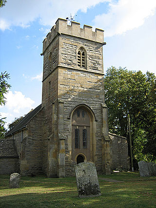
Cubley is a parish of two closely linked villages six miles (10 km) south of Ashbourne in Derbyshire. Great Cubley and Little Cubley are known collectively as Cubley. The parish church of St Andrew is roughly equidistant from the two, but is formally in Great Cubley. The church is Grade I listed. The population of the civil parish taken at the 2011 Census was 232.
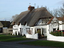
Ardens Grafton is a hamlet or small village in the Stratford-on-Avon District of Warwickshire, England, situated about 4 miles (6.4 km) east of Alcester and 14 miles (23 km) west of the county town of Warwick. It has a main street and consists mostly of houses constructed of local stone with tiled roofs, with the exception of two properties, 'Manor Cottage' and 'Chapel House' both of which have timber-framed walls and a thatched roof. Two other buildings retain fragments of ancient framing. During the reign of Edward III in 1347 the village was recorded as Grafton Inferior while neighbouring Temple Grafton, 0.50 miles (0.80 km) to the East, was named Superior Other designations used during the Middle Ages were Nether Grafton, Grafton Inferior or Grafton Minor whilst the larger village of Temple Grafton was distinguished as Over Grafton, Grafton Superior, Church Grafton, or Grafton Major. A reference to 'Temple Grafton alias Ardens Grafton' occurs in 1650.

Sopworth is a small village and civil parish in northwest Wiltshire, England, on the county's border with Gloucestershire. The village lies about 1.7 miles (2.7 km) west of Sherston and 6.5 miles (10 km) west of Malmesbury. The parish is within the Cotswolds Area of Outstanding Natural Beauty.

Preston Bagot is a village and civil parish in the Stratford district of Warwickshire, England, about 6 miles (9.7 km) west of the county town of Warwick. According to the 2001 census the population was 147, reducing to 127 at the 2011 census.