Napton on the Hill

Last updated

Napton on the Hill
Oxford Canal from Napton.jpg
The Oxford Canal viewed from Napton
Warwickshire UK location map.svg
Red pog.svg
Napton on the Hill
Location within Warwickshire
Population1,416 (2021 Census)
OS grid reference SP4661
Civil parish
  • Napton on the Hill
District
Shire county
Region
Country England
Sovereign state United Kingdom
Post town SOUTHAM
Postcode district CV47
Dialling code 01926
Police Warwickshire
Fire Warwickshire
Ambulance West Midlands
UK Parliament
Website Napton on the Hill
List of places
UK
England
Warwickshire
52°14′42″N1°19′34″W / 52.245°N 1.326°W / 52.245; -1.326

Napton on the Hill is a village and civil parish in the Stratford-on-Avon District of Warwickshire, England. The population of the civil parish taken at the 2021 census was 1,416. [1]

Contents

Manor

The toponym Napton is derived from the Old English cnæpp meaning 'hilltop' and tūn meaning 'settlement' in the Old English language. In 1086 the Domesday Book recorded the village as Neptone. [2] The hill on which the village is built is just over 500 feet (150 m) above sea level, commanding the remainder of the parish which for the most part is at a height of about 300 feet (91 m). [3] The Domesday Book records that in 1086 Robert de Beaumont, Count of Meulan held the principal manor of Napton. [3] In 1107 Henry I made de Beaumont Earl of Leicester and de Beaumont's manor at Napton became part of the honour of Leicester Castle. [3] When Robert de Beaumont, 4th Earl of Leicester died in 1204 leaving no male heir his estates were divided between his two sisters. [3]

Napton was included in the half that passed to his younger sister Margaret, and thereby to her husband Saer de Quincy who in 1207 was made Earl of Winchester. Napton was still part of the honour of Winchester Castle in 1271 [3] but Roger de Quincy, 2nd Earl of Winchester had died in 1265 with no male heir, leaving his estates to his three daughters. In 1285 the husbands of two of these, Alexander Comyn, Earl of Buchan and William de Ferrers, 5th Earl of Derby, jointly claimed view of frankpledge over Napton. [3] There are further references to Napton's feudal overlordship in the 14th century and in 1413. [3]

Parish church

The oldest parts of the Church of England parish church of St Lawrence include the chancel, [4] which was built in the 12th century [3] and still has three Norman windows in its north wall. [4] The south doorway of the nave is also from the end of the 12th century. [4] Prof. Louis Salzman considered that the north and south transepts were also 12th century [3] but Prof. Nikolaus Pevsner and Alexandra Wedgwood proposed a later date of about 1275, noting their triplets of Early English Gothic lancet windows. [5] The north and south aisles were added in the 13th century [3] after the transepts. [5] The lower stages of the bell tower date from about 1300. [5] The east window of the south transept is a later Perpendicular Gothic addition. [5]

The south porch reuses a mixture of Early English and Perpendicular masonry and has puzzled historians. Louis Francis Salzman thought it could have been built either at the end of the 16th century or in the 17th century [3] but Nikolaus Pevsner and Alexandra Wedgwood suspected the involvement of J. Croft, the architect who restored the church in 1861. [5] The vestry may also have been added in the 17th century [3] and the upper stage of the tower was rebuilt early in the 18th century. [5] After this rebuilding a ring of five bells was cast in 1731 and hung in the tower. [6]

The tenor was recast in 1874 and John Taylor & Co rehung all the bells in 1958. [6] The ring was increased to six bells by the addition of the treble cast by Whitechapel Bell Foundry in 1963. [6] St. Lawrence's is at the top of the hill, making it a local landmark and giving it commanding views over the surrounding countryside, especially from the top of the tower. St. Lawrence's parish is now part of a single Church of England benefice with the parishes of Lower Shuckburgh and Stockton, [7] part of the Bridges Group of parishes. [8] Actor Ed Bishop is buried in the churchyard.

Economic and social history

Napton Windmill in 2022 Napton-on-the-Hill windmill 08.jpg
Napton Windmill in 2022

In the 14th century Napton was granted a market charter by King Edward II and throughout the Middle Ages it was one of the largest settlements in Warwickshire. However the market died out, and the population of the village today of around 1,000, is roughly the same as it was in the year 1400. Napton had a windmill by 1543. [3] The present stone-built tower mill is a later structure, dating from the 18th or early 19th century that was derelict in 1966 but has since been restored. It is a Grade II listed building. [9]

Napton had separate schools for girls and boys until 1948 when they were merged to form the current St. Lawrence Church of England Primary School, [10] which moved to its current premises in 1997. [11]

Canals

The first section of the Oxford Canal from Hawkesbury Junction was completed in 1771 [12] and it reached Napton in 1774. [13] This made Napton the head of navigation for coal supplies to be forwarded by road to Banbury, Bicester, Woodstock and Oxford [13] until 1777, when the canal reached Fenny Compton which then took over as the trans-shipment point. [14] The Oxford Canal's chief engineer, Samuel Simcock, designed the canal to be a contour canal as much as possible, so he routed it around three sides of Napton Hill to minimise the number of locks needed. Even so, to climb from Napton Wharf to the summit pound at Marston Doles required eight locks around the hill (nos. 8–15) and another at Marston Doles (no. 16), that between them raise boats by a total of 52 feet (16 m). [15]

The 11 miles (18 km) long summit pound between Marston Doles and Claydon suffered from a shortage of water so Parliament passed an Act in 1786 authorising the company to use any water supply within 1,000 yards (910 m) of the canal. Just over 1 mile (1.6 km) south of Napton it sank a well that fed the summit pound via a 900 yards (820 m) feeder arm westwards to the canal between locks 11 and 12 and then a 1 mile (1.6 km) channel beside the canal from there to just above Marston Doles lock. [16] An engine house with a steam engine and pump were built at the well-head (grid reference SP 4655 5910 ) and the well seems to have begun operation in 1793. [17] The boiler needed replacement as early as 1794 and an accident with the engine killed a workman in 1796. [17]

In 1800 the Warwick and Napton Canal (W&N) was completed, joining the Oxford Canal at Napton Junction. [18] To reach the same level as the Oxford Canal the W&N ascended three locks at Calcutt just north of Napton parish. With each passage of a narrowboat through Calcutt Lock the Oxford Canal lost a certain amount of water so the W&N agreed to pay the Oxford 2 shillings (2/-) (10 new pence) for each such passage. [18] In 1805 the Grand Junction Canal was completed, [19] joining the Oxford Canal at Braunston 4.5 miles (7.2 km) east of Napton and completing the direct canal route between Birmingham and London. Between 1808 and 1811 the W&N built a reservoir at Ashby St Ledgers 7 miles (11 km) from Napton to feed both the Oxford and the W&N via the Grand Junction Canal. [20] This enabled the Oxford to cease regular pumping at Napton and stop charging the W&N two shillings for each boat through Calcutt Locks. [21]

A century later, in autumn 1911, the canals again suffered a water shortage so the Oxford Canal brought its well at Napton back into use. [22] The old pumping engine had long been out of action so the company hired two Oxford Steam Plough Company steam ploughing engines to work the pump. [22] In 1974 there was another water shortage and British Waterways resorted to back-pumping water up Napton Locks. [23] In 1928 the Grand Junction Canal took over the W&N and Warwick and Birmingham Canals to form the Grand Union Canal. [24] The Grand Union wanted to widen its route to enable it to take barges 12.5 feet (3.8 m) wide, so in 1931 an Act of Parliament gave the Grand Union special powers over the Oxford Canal to widen the section between Braunston and Napton Junctions. [24] Between 1932 and 1947 it widened bridges between Braunston and Napton and increased the depth of the canal to 5.5 feet (1.7 m). [24] The canals are now primarily a leisure facility and Napton Junction has a marina that offers moorings and narrowboats for hire.

Napton Festival

On 16 September 2006 the first Napton Festival was held at Holt Farm on Holt Road. The headline act was the hard rock band Girlschool. The festival was repeated in the same place in 2007, with two stages and with The Sweet and the Hollies as its main acts. In 2008 the main acts were Bad Company on the main stage and Aynsley Lister in the marquee. The 2008 festival extended to the Friday night with Jilted Generation performing in the marquee. Smaller events were held in Napton village in 2009 and 2010, both headlined by Whole Lotta DC. In 2011 the festival was held in a new site on the edge of Napton village. It was a two-day event with bands including the Ripps on the Friday night and the Bluetones and the Total Stone Roses headlining the Saturday night.

Notable people

The BBC's Rural Affairs Correspondent and Director of Checked Shirt TV Limited, Thomas John Gillespie "Tom" Heap, the son of the Foreign and Commonwealth Office's John Arnfield Heap, [25] lives in the village. [26] The American actor Ed Bishop (1932–2005) is buried in the parish churchyard, having lived in the village for several years.[ citation needed ]

Related Research Articles

<span class="mw-page-title-main">Grand Union Canal</span> Canal in England

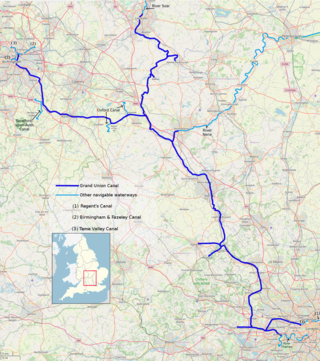
The Grand Union Canal in England is part of the British canal system. It is the principal navigable waterway between London and the Midlands. Starting in London, one arm runs to Leicester and another ends in Birmingham, with the latter stretching for 137 miles (220 km) with 166 locks from London. The Birmingham line has a number of short branches to places including Slough, Aylesbury, Wendover, and Northampton. The Leicester line has two short arms of its own, to Market Harborough and Welford.

<span class="mw-page-title-main">Oxford Canal</span> Canal in England

The Oxford Canal is a 78-mile (126 km) narrowboat canal in southern central England linking the City of Oxford with the Coventry Canal at Hawkesbury via Banbury and Rugby. Completed in 1790, it connects to the River Thames at Oxford, and links with the Grand Union Canal, which it is combined with for 5 miles (8 km) between to the villages of Braunston and Napton-on-the-Hill.

<span class="mw-page-title-main">Braunston</span> Human settlement in England

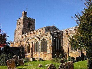
Braunston is a village and civil parish in the West Northamptonshire unitary authority area of Northamptonshire, England, next to the border with Warwickshire. At the 2011 Census, the parish had a population of 1,759. Braunston is situated just off the A45 main road and lies between the towns of Daventry and Rugby. Braunston is categorised by the Office for National Statistics as Suburbs and Small Towns: Suburbs There are 776 households in the village.

<span class="mw-page-title-main">Coventry Canal</span> Canal in Staffordshire, England

The Coventry Canal is a navigable narrow canal in the Midlands of England.

<span class="mw-page-title-main">Ansty, Warwickshire</span> Human settlement in England

Ansty is a village and civil parish in the Rugby Borough of Warwickshire, England, about 5 miles (8 km) northeast of Coventry city centre and 7 miles (13 km) south of Hinckley. Ansty is on the B4065, which used to be the main road between Coventry and Hinckley. The junction between the M6 and M69 motorways and A46 road is 1 mile (1.6 km) southwest of the village. The parish had a population of 299 at the 2021 Census.

<span class="mw-page-title-main">Barby, Northamptonshire</span> Village in Northamptonshire, England

Barby is a village and civil parish about 5 miles (8 km) north of Daventry in Northamptonshire, England. The 2011 Census recorded the parish population as 2,336. Barby is located right off the M45 motorway a short spur from the M1 motorway to the A45 Trunk Road.

<span class="mw-page-title-main">Whilton Locks</span>

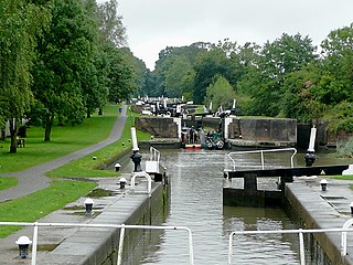
Whilton Locks is the name of a flight of seven locks on the Grand Union Canal near Daventry, in the county of Northamptonshire, England. They are also referred to as Buckby Lock Flight.

<span class="mw-page-title-main">Cropredy</span> Human settlement in England

Cropredy is a village and civil parish on the River Cherwell, 4 miles (6.4 km) north of Banbury in Oxfordshire.

<span class="mw-page-title-main">Warwickshire ring</span>

The Warwickshire ring is a connected series of canals forming a circuit around the West Midlands area of England. The ring is formed from the Coventry Canal, the Oxford Canal, the Grand Union Canal, the Stratford-upon-Avon Canal and the Birmingham and Fazeley Canal. It is a popular route with tourists due to its circular route and mixture of urban and rural landscapes.

<span class="mw-page-title-main">Willoughby, Warwickshire</span> Human settlement in England

Willoughby is a village and civil parish about 5 miles (8 km) south of Rugby, Warwickshire, England. The village is about 4.5 miles (7 km) northwest of Daventry in neighbouring Northamptonshire and the eastern boundary of the parish forms part of the county boundary.

Lea Marston is a village and civil parish on the River Tame in Warwickshire, England, about 7 miles (11 km) south-west of Atherstone. Lea Marston is close to the county boundary with Birmingham and about 4.5 miles (7.2 km) east of Sutton Coldfield.

<span class="mw-page-title-main">Whichford</span> Human settlement in England

Whichford is a village and civil parish in Warwickshire, England, about 5 miles (8 km) southeast of Shipston-on-Stour. The parish adjoins the county boundary with Oxfordshire and the village is about 4+12 miles (7 km) north of the Oxfordshire town of Chipping Norton.

<span class="mw-page-title-main">Kingswood Junction</span>

Kingswood Junction is a canal junction where the Stratford-upon-Avon Canal meets the Grand Union Canal at Kingswood, Warwickshire, England.

<span class="mw-page-title-main">Hawkesbury Junction</span>

Hawkesbury Junction or Sutton Stop is a canal junction in England, at the northern limit of the Oxford Canal where it meets the Coventry Canal, near Hawkesbury Village, Warwickshire, between Bedworth and Coventry. The alternative name, Sutton Stop, arises from the name of a family which provided several lock keepers there in the nineteenth century.

<span class="mw-page-title-main">Ettington</span> Human settlement in England

Ettington is a village and civil parish about 5.5 miles (9 km) south-east of Stratford-upon-Avon in Warwickshire, England. The 2011 Census recorded the parish's population as 1,171. The present village is on the A422 main road linking Stratford and Banbury. The A429 main road linking Warwick and Cirencester used to run through the village, and now uses a bypass just west of it. The Fosse Way Roman road crosses the A422 0.6 miles (1 km) east of the village.

<span class="mw-page-title-main">Claydon, Oxfordshire</span> Human settlement in England

Claydon is a village and former civil parish, now in Claydon with Clattercot, in the Cherwell district, in Oxfordshire, England. The village is about 6 miles (10 km) north of Banbury and about 417 feet (127 m) above sea level on a hill of Early Jurassic Middle Lias clay.

<span class="mw-page-title-main">Tysoe</span> Human settlement in England

Tysoe is a civil parish in the Stratford-on-Avon District of Warwickshire, England. The parish is on the boundary with Oxfordshire, about 7+12 miles (12 km) northwest of Banbury. The parish includes the contiguous villages of Middle and Upper Tysoe and the separate hamlet of Lower Tysoe. The 2011 census recorded the parish population as 1,143.

<span class="mw-page-title-main">Whatcote</span> Human settlement in England

Whatcote is a village and civil parish in Warwickshire, England, about 4 miles (6.4 km) northeast of Shipston on Stour in the Vale of the Red Horse. The population at the 2011 census was 143.

<span class="mw-page-title-main">Pillerton Hersey</span> Village and civil parish in Warwickshire, England

Pillerton Hersey is a village and civil parish about 5.5 miles (9 km) north of Shipston-on-Stour in Warwickshire, England. The village is on a stream that flows northwest to join the River Dene. The 2011 Census recorded the parish's population as 170.

<span class="mw-page-title-main">Bascote Locks</span>

Bascote locks form a flight of four locks on the Grand Union Canal, which is part of the British canal system and connects London and Birmingham. The lock flight has a staircase, and at the highest lock the remains of older narrow locks can be seen.

References

  1. "Napton on the Hill Parish in West Midlands". City Population. Retrieved 30 January 2024.
  2. "History of Napton – Napton Parish Council".
  3. 1 2 3 4 5 6 7 8 9 10 11 12 13 Salzman 1951 , pp. 181–187
  4. 1 2 3 Pevsner & Wedgwood 1966 , p. 358
  5. 1 2 3 4 5 6 Pevsner & Wedgwood 1966 , p. 359
  6. 1 2 3 Chester, Mike. "Napton on the Hill St Lawrence". Church Bells of Warwickshire. Archived from the original on 19 July 2011.
  7. Napton on the Hill – St. Lawrence, Napton on the Hill
  8. The Bridges Group
  9. Historic England. "Napton Windmill (1185610)". National Heritage List for England . Retrieved 24 April 2022.
  10. "St Lawrence CE Primary School with Little Lawrences". Archived from the original on 19 December 2009. Retrieved 26 November 2009.
  11. "A brief History of Napton on the Hill, Part 2". Napton on the Hill.
  12. Compton 1976, p. 19.
  13. 1 2 Compton 1976 , p. 20
  14. Compton 1976, p. 22.
  15. British Waterways Board 1965, p. 10.
  16. Compton 1976, p. 48.
  17. 1 2 Compton 1976 , p. 49
  18. 1 2 Compton 1976 , p. 84
  19. Compton 1976, p. 79.
  20. Compton 1976, p. 91.
  21. Compton 1976, p. 92.
  22. 1 2 Compton 1976 , p. 137
  23. Compton 1976, pp. 153–154.
  24. 1 2 3 Compton 1976 , p. 140
  25. "Obituaries: John Heap". The Daily Telegraph . London. 18 March 2006. Retrieved 20 August 2014.
  26. "Checked Shirt TV Limited". OpenCompany.co.uk. Archived from the original on 22 August 2014. Retrieved 20 August 2014.

Sources