
Vexillology is the study of the history, symbolism and usage of flags or, by extension, any interest in flags in general. The word is a synthesis of the Latin word vexillum ("flag") and the Greek suffix -logia ("study").

Todt Hill is a 401-foot-tall (122 m) hill formed of serpentine rock on Staten Island, New York. It is the highest natural point in the five boroughs of New York City and the highest elevation on the entire Atlantic coastal plain from Florida to Cape Cod. The summit of the ridge is largely covered in woodlands as part of the Staten Island Greenbelt, although much of the surrounding area is developed and residential. It is considered one of the most exclusive and most expensive areas of Staten Island.

Cumorah is a drumlin in Manchester, New York, United States, where Joseph Smith said he found a set of golden plates which he translated into English and published as the Book of Mormon.
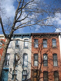
Boerum Hill is a small neighborhood in the northwestern portion of the New York City borough of Brooklyn, bounded by Schermerhorn Street to the north and Fourth Avenue to the east. The western border is variously given as either Smith or Court Streets, and Warren or Wyckoff Streets as the southern edge.

Anthony's Nose is a peak along the Hudson River at the north end of Westchester County, New York.
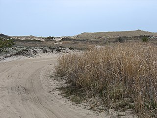
Napeague State Park is a 1,364-acre (5.52 km2) state park in the town of East Hampton in Suffolk County, New York. The largely undeveloped park stretches across the entire narrow width of the South Fork of Long Island from the Atlantic Ocean to Gardiners Bay and Block Island Sound. The park is located on either side of the Montauk Highway on the "Napeague Stretch" between Amagansett and Montauk. The hamlet of Napeague is located on the park's edge.
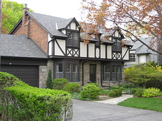
Humber Valley Village is a neighbourhood located in Toronto, Ontario, Canada. It is within the former City of Etobicoke and is a relatively affluent community. The boundaries are from Dundas Street on the south to Islington Avenue to the west, Eglinton Avenue to the north, and the Humber River in the east. The neighbourhood is in the political riding of Etobicoke Centre.
Mount Raimer, 2,572 feet (784 m), is a prominent peak in the Taconic Mountains of western Massachusetts and adjacent New York. The west side and summit are located in New York; the east slopes lie within Massachusetts. The summit ridge is part meadow and part wooded with red spruce, balsam fir, and northern hardwood tree species. It is notable for its views of the Hoosic River valley and Hudson River Valley. The 35 mi (56 km) Taconic Crest Trail traverses the mountain. Much of the upper slopes and summit are within protected conservation land. The mountain is the location of a defunct ski area.
White Rock, 2,550 feet (780 m), is the high point on a 7 mi (11 km) ridgeline in the Taconic Mountains. The ridge is located in the tri-state corner of New York, Massachusetts, and Vermont in the towns of Petersburgh, Williamstown, and Pownal. The ridge has several distinct knobs; those with names are, from south to north: White Rocks, 2,365 feet (721 m); Smith Hill, 2,330 feet (710 m); White Rock, the high point 2,550 feet (780 m); and Bald Mountain 2,485 feet (757 m). The Snow Hole, located along the ridgeline between Bald Mountain and the White Rock, is a crevasse in which snow can be found well into the summer.

The Otis Pike Fire Island High Dune Wilderness, also known as the Otis G. Pike Wilderness Area or the Fire Island Wilderness, is a federally protected wilderness area located on Fire Island, a barrier island off the south shore of Long Island, New York, United States. The 1,380-acre wilderness is contained within the larger Fire Island National Seashore.

Jemele Juanita Hill is an American sports journalist who writes for The Atlantic. She worked nearly 12 years for sports conglomerate ESPN. She wrote a column for ESPN.com's Page 2 and formerly hosted ESPN's His and Hers. In June 2013, she succeeded Jalen Rose on ESPN2's Numbers Never Lie. In February 2017, Hill and Michael Smith became co-hosts of SC6, the 6 p.m. (ET) edition of ESPN's flagship SportsCenter. Hill remained in that role until February 2018, when she moved to ESPN's website The Undefeated. She joined The Atlantic in October 2018.
Quaker Hill is a hamlet in the town of Pawling in Dutchess County, New York, United States. The community shares its name with the twelve-mile-long ridge on which it is located; the ridge is located near the Connecticut state line. Quaker Hill is in the southern portion of the area known as the "Oblong" that was designated by the Treaty of Dover in 1731, and "known from pre-Revolutionary times as Quaker Hill". In colonial times Quaker Hill separated "the English [settlers] of New England and the Hudson Valley Dutch population."

Fitch Hill is a mountain located in Central New York Region of New York by Pierstown. Fitch Hill is named after the Fitch family who were early settlers in the area.
King Hill is a hill located in Central New York region of New York by Richfield Springs, New York.
Wooley Hill is a mountain in the Central New York Region of New York. It is located northwest of Garrattsville, New York. Gross Hill is located southwest of Wooley Hill.
Gross Hill is a mountain in the Central New York Region of New York. It is located northwest of Garrattsville, New York. Crystal Lake is located south and Wooley Hill is located northeast of Gross Hill.
Harris Hill is a mountain in the Central New York region of New York. It is located in Otsego County west of Morris, New York. Pickens Pond is located north of Harris Hill.
Briar Hill is a mountain located in Central New York region of New York located east of Burlington, New York.
Pigeon Hill is a small mountain chain located in Central New York region of New York located northeast of Burlington, New York. It is made by four main peaks with the highest being 2057 feet.
Wilders Hill is a mountain located in Central New York Region of New York east of Richfield Springs, New York. Waiontha Mountain is located southeast of Wilders Hill.


