Related Research Articles

Rockland County is the southernmost county on the west side of the Hudson River in the U.S. state of New York. It is part of the New York City metropolitan statistical area. It is about 6 miles from the Bronx at their closest points. The county's population, as of the 2020 United States Census, is 338,329, making it the third-most densely populated county outside New York City within New York. The county seat is New City. Rockland County is accessible via the New York State Thruway, which crosses the Hudson to Westchester at the Tappan Zee Bridge ten exits up from the NYC border, as well as the Palisades Parkway five exits up from the George Washington Bridge. The county's name derives from "rocky land", as the area has been aptly described, largely due to the Hudson River Palisades.

Scouting in New York has a long history, from the 1910s to the present day, serving thousands of youth in programs that suit the environment in which they live. The first National Boy Scouts of America (BSA) Headquarters was in New York City, and the Girl Scouts of the USA National Headquarters is currently located at 420 5th Avenue, New York, New York.
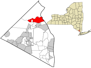
Stony Point is a hamlet and census-designated place in the town of Stony Point, Rockland County, New York, United States. It is located north of West Haverstraw, east of Harriman State Park, south of Tomkins Cove, and west of the Hudson River. The population was 12,147 at the 2010 census.
Stony Point is a town in Rockland County, New York, United States. It is part of the New York City Metropolitan Area. The town is located north of the town of Haverstraw, east and south of Orange County, and west of the Hudson River and Westchester County. The population was 15,059 at the 2010 census. The name of the town is derived from a prominent projection into the Hudson River.
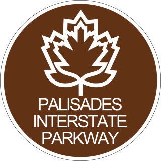
The Palisades Interstate Parkway (PIP) is a 38.25-mile-long (61.56 km) limited-access highway in the U.S. states of New Jersey and New York. The parkway is a major commuter route into New York City from Rockland and Orange counties in New York and Bergen County in New Jersey. The southern terminus of the route is at the George Washington Bridge in Fort Lee, New Jersey, where it connects to Interstate 95 (I-95), New Jersey Route 4, U.S. 1, U.S. 9, and US 46. Its northern terminus is at a traffic circle in Fort Montgomery, New York, where the PIP meets US 9W and US 202 at the Bear Mountain Bridge. At exit 18, the PIP forms a concurrency with US 6 for the remaining duration of its run.
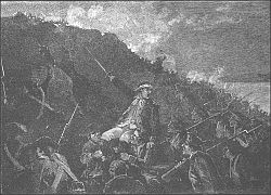
The Battle of Stony Point took place on July 16, 1779, during the American Revolutionary War. In a well-planned and -executed nighttime attack, a highly trained select group of George Washington's Continental Army troops under the command of Brigadier General "Mad Anthony" Wayne defeated British troops in a quick and daring assault on their outpost in Stony Point, New York, approximately 30 mi (48 km) north of New York City.

The Palisades, also called the New Jersey Palisades or the Hudson River Palisades, are a line of steep cliffs along the west side of the lower Hudson River in Northeastern New Jersey and Southeastern New York in the United States. The cliffs stretch north from Jersey City about 20 miles (32 km) to near Nyack, New York, and visible at Haverstraw, New York. They rise nearly vertically from near the edge of the river, and are about 300 feet (90 m) high at Weehawken, increasing gradually to 540 feet (160 m) high near their northern terminus. North of Fort Lee, the Palisades are part of Palisades Interstate Park and are a National Natural Landmark.
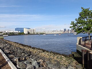
Weehawken Cove is a cove on the west bank of the Hudson River between the New Jersey municipalities of Hoboken to the south and Weehawken to the north. At the perimeter of the cove are completed sections the Hudson River Waterfront Walkway, offering views of Manhattan and the Palisades. The name Weehawken comes from the Lenape, and can translate as "at the end of", either the Hudson Palisades or the stream which flowed from them into the cove, later the site of the nearby Lincoln Tunnel.

Hudson Highlands State Park is a non-contiguous state park in the U.S. state of New York, located on the east side of the Hudson River. The park runs from Peekskill in Westchester County, through Putnam County, to Beacon in Dutchess County, in the eastern section of the Hudson Highlands.

The Hudson Highlands are mountains on both sides of the Hudson River in New York state lying primarily in Putnam County on its east bank and Orange County on its west. They continue somewhat to the south in Westchester County and Rockland County, respectively.

Doodletown was an isolated hamlet in the Town of Stony Point, Rockland County, New York, United States. Purchased by the Palisades Interstate Park Commission during the 1960s, it is now part of Bear Mountain State Park and a popular destination for hikers, birdwatchers, botanists, and local historians. It is located north of Jones Point, west of Iona Island, and southeast of Orange County. The former settlement is now a ghost town.

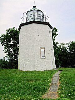
Stony Point Battlefield is a historic site in Rockland County, New York; the location of the 1779 Battle of Stony Point during the American Revolutionary War. It is a National Historic Landmark and has a museum.
Bear Mountain is one of the best-known peaks of New York's Hudson Highlands. Located partially in Orange County in the town of Highlands and partially in Rockland County in the town of Stony Point, it lends its name to the nearby Bear Mountain Bridge and Bear Mountain State Park that contains it.

Iona Island is a 556-acre (2.25 km2) island of the Hudson River in the town of Stony Point, New York, on its west bank. The island is located approximately one mile (1.6 km) south of the Bear Mountain Bridge and is separated from the Hudson's western shore by mudflats and freshwater tidal marshes. It is part of Bear Mountain State Park, although it is occasionally listed separately as Iona Island State Park. From 1899 to 1947 the island was used as the Naval Ammunition Depot Iona Island.
Tomkins Cove is a hamlet in the Town of Stony Point, Rockland County, New York, United States, located north of Stony Point; east of Harriman State Park; south of Doodletown and west of the Hudson River. It is located north-northwest of New York City. The population is approximately 1,739 and the ZIP Code is 10986. The community is served by the 786 exchange in area code 845.
Jones Point is a former hamlet located in the town of Stony Point in Rockland County in the state of New York, United States, located north of Tomkins Cove; east of Bear Mountain State Park; south of Iona Island; and west of the Hudson River. It is directly across the Hudson River from the city of Peekskill and lies at the foot of Dunderberg Mountain.
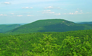
Dunderberg Mountain is a 1,086-foot (331 m) mountain on the west bank of the Hudson River at the southern end of the Hudson Highlands. It lies just above Jones Point, New York, within Bear Mountain State Park and the town of Stony Point in Rockland County, New York.

Johnsontown is a former hamlet in the town of Stony Point in Rockland County, New York, United States.
The recorded history of Rockland County, New York begins on February 23, 1798, when the county was split off from Orange County, New York and formed as its own administrative division of the state of New York. It is located 6 miles (9.7 km) north-northwest of New York City, and is part of the New York Metropolitan Area. The county seat is the hamlet of New City. The name comes from rocky land, an early description of the area given by settlers. Rockland is New York's southernmost county west of the Hudson River. It is suburban in nature, with a considerable amount of scenic designated parkland. Rockland County does not border any of the New York City boroughs, but is only 9.5 miles (15.3 km) north of Manhattan at the counties' two respective closest points

Lee Woodward Zeigler, also known as Albert Lee Zeigler, was an American artist who began his career as an illustrator and later worked as a muralist.
References
- ↑ Weinstock, Cheryl Platzman (2001-08-12). "If You're Thinking of Living In/Tomkins Cove; A Bucolic Hamlet in Growing Demand". The New York Times. ISSN 0362-4331 . Retrieved 2020-03-10.
- ↑ "Archived copy" (PDF). The Hudson Valley Magazine. Archived from the original (PDF) on 2009-03-27. Retrieved 2009-02-03.
{{cite web}}: CS1 maint: archived copy as title (link) - ↑ "Revolutionary War Battles 1775-1783". www.myrevolutionarywar.com. Retrieved 2020-03-10.
- ↑ "Open Space Institute Protects Revolutionary War Site -- by the Half Moon Press". Archived from the original on 2007-10-21. Retrieved 2009-02-03.
- ↑ l, We have picked; About, Scapes That We Care. "Where and How We Protect Land for Recreation". Open Space Institute. Retrieved 2020-03-10.
- ↑ Gibson, Wendy (2002-12-06). "State Parks Announce Historic Preservation Awards". New York State Office of Parks. Archived from the original on 2006-09-24. Retrieved 2020-03-09.