
The Himalayas, or Himalaya, , is a mountain range in Asia separating the plains of the Indian subcontinent from the Tibetan Plateau. The range has many of Earth's highest peaks, including the highest, Mount Everest, at the border between Nepal and China. The Himalayas include over fifty mountains exceeding 7,200 m (23,600 ft) in elevation, including ten of the fourteen 8,000-metre peaks. By contrast, the highest peak outside Asia is 6,961 m (22,838 ft) tall.

The Adirondack Mountains form a massif in northeastern New York, United States. Its boundaries correspond roughly to the boundaries of Adirondack Park. They cover about 5,000 square miles (13,000 km2). The mountains form a roughly circular dome, about 160 miles (260 km) in diameter and about 1 mile (1,600 m) high. The current relief owes much to glaciation. There are more than 200 lakes around the mountains, including Lake George, Lake Placid, and Lake Tear of the Clouds, which is the source of the Hudson River. The Adirondack Region is also home to hundreds of mountain summits, with some reaching heights of 5000 feet or more.

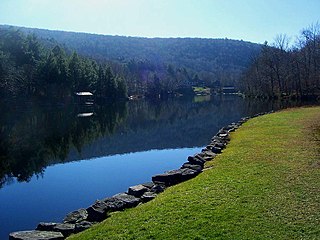
Indian Lake is a town in Hamilton County, New York, United States. The population was 1,352 at the 2010 census. The name is from a lake of the same name that is largely inside the town. There are no permanent stop lights in the town. Law enforcement is provided by New York State Troopers and Hamilton County Sheriff's Office.

The Santa Ana Mountains are a short peninsular mountain range along the coast of Southern California in the United States. They extend for approximately 61 miles (98 km) southeast of the Los Angeles Basin largely along the border between Orange and Riverside counties.

Deloraine is an unincorporated urban community in the Municipality of Deloraine – Winchester within the Canadian province of Manitoba that held town status prior to January 1, 2015. It is situated near the Turtle Mountains in the southwestern corner of the province. Located in the Westman Region, the community is 100 kilometres south of Brandon. Deloraine originally incorporated as a village in 1904 and then as a town in 1907. Its town status was relinquished in 2015 when it amalgamated with the Rural Municipality of Winchester.

The Mohonk Mountain House, also known as Lake Mohonk Mountain House, is an American resort hotel located on the Shawangunk Ridge in Ulster County, New York. Its location in the town of New Paltz, New York is just beyond the southern border of the Catskill Mountains, west of the Hudson River.

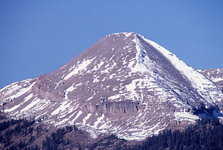
Capitol Peak is a high and prominent mountain summit in the Elk Mountains range of the Rocky Mountains of North America. It is the 52nd highest mountain in North America. The 14,137-foot (4,309 m) fourteener is located in the Maroon Bells-Snowmass Wilderness of White River National Forest, 8.7 miles (14.0 km) east by south of the community of Redstone in Pitkin County, Colorado, United States.

White River National Forest is a National Forest in northwest Colorado. It is named after the White River that passes through its northern section. It is the most visited National Forest in the United States, primarily from users of the twelve ski areas within its boundaries.

The Maroon Bells are two peaks in the Elk Mountains, Maroon Peak and North Maroon Peak, separated by about half a kilometer. The mountains are on the border between Pitkin County and Gunnison County, Colorado, United States, about 12 miles (19 km) southwest of Aspen. Both peaks are fourteeners. Maroon Peak, at 14,163 feet (4317 m), is the 27th highest peak in Colorado. North Maroon Peak, at 14,019 feet (4273 m), is the 50th highest. The view of the Maroon Bells to the southwest from the Maroon Creek valley is very heavily photographed. The peaks are located in the Maroon Bells–Snowmass Wilderness of White River National Forest. Maroon Bells-Snowmass Wilderness was one of five areas in Colorado designated as wilderness in the original Wilderness Act of 1964. The Wilderness area surrounds the extremely popular Maroon Bells Scenic Area, which is a major access point for Wilderness travel.
Winnisook Lake is an artificial lake located in Oliverea, New York, United States. It is the source of Esopus Creek and the highest lake in the Catskill Mountains at 2,664 feet (812 m) above sea level.

Udhampur is a district in the Indian Union territory of Jammu and Kashmir. Covering an area of 4,550 square kilometres (1,760 sq mi) in the Himalayan mountains, the district has its headquarters in the town of Udhampur. The Northern Command headquarters of the Indian Army is located in the district.

Carson National Forest is a national forest in northern New Mexico, United States. It encompasses 6,070 square kilometers and is administered by the United States Forest Service. The Forest Service's "mixed use" policy allows for its use for recreation, grazing, and resource extraction.
Treaty 2 was entered in to on 21 August 1871 at Manitoba House, Rupertsland, with representatives of the Queen of Great Britain and Ireland. The original Anishinaabe, who were present, constitute Treaty 2 today. It is known that many of the chiefs and leaders within the territory were at the early gathering and after the treaty was agreed to. Those who were not present were represented through Mekis until they indicated where they wished their farming reserves to be established. The treaty reaffirmed the inherent rights that the Anishinaabe had prior to European contact, located where southwestern Manitoba is today and a small part of southeastern Saskatchewan.

Wild Basin a region in the southeast corner Rocky Mountain National Park in Colorado, United States. The primary entrance is located north of Allenspark off State Highway 7.
Indian Mountain State Park is a state park in Campbell County, Tennessee, in the southeastern United States. Established in 1971, the park consists of 213 acres (0.86 km2) situated at the base of Indian Mountain, a 1,949-foot (594 m) summit that overlooks the Elk Valley in the Cumberland Mountains. The park is located immediately west of the city of Jellico, and the history and development of the two are intertwined to a great extent.

Turtle Mountain Indian Reservation is a reservation located in northern North Dakota, United States. It is the land base for the Turtle Mountain Band of Chippewa Indians. The population of the Turtle Mountain Indian Reservation consists of Plains Ojibwe and Métis and was first established in 1882.

Mount Marshall is a mountain located in Essex County, New York. Originally named for Governor DeWitt Clinton, and then for Herbert Clark, it was renamed for wilderness activist Bob Marshall (1901–1939) after his death. Marshall is part of the MacIntyre Mountains. Mount Marshall is flanked to the northeast by Iroquois Peak, and faces Wallface Mountain to the northwest across Indian Pass.

The Cedar River is a 38.5-mile-long (62.0 km) river in the central Adirondacks, in Hamilton County, New York. It rises at the outlet of Cedar Lake in the Town of Arietta and flows northeast into the Town of Lake Pleasant, where it passes through the Cedar River Flow. Continuing northeast and east, it passes through the Town of Indian Lake and remote corners of the Towns of Minerva and Newcomb to join the Hudson River northeast of the hamlet of Indian Lake. The Northville-Placid Trail goes past the Cedar Lakes and along the Cedar River to the flow.

Wallface Mountain is a mountain located in Essex County, New York. The mountain is named after the cliff on its southeastern side. Wallface is flanked to the west by MacNaughton Mountain, and faces Mount Marshall to the southeast across Indian Pass.
Antler Peak, el. 10,063 feet (3,067 m) is a prominent mountain peak in the Gallatin Range in Yellowstone National Park. The peak was originally named Bell's Peak in honor of an Assistant Secretary of the Interior by either Philetus Norris, the second park superintendent or W.H.Holmes, a U.S. Geological Survey geologist in 1878. However, in 1885, Arnold Hague of the U.S. Geological Survey renamed the peak Antler Peak because of the numerous shed elk and deer antlers found on its slopes.

