
Madison County is a county located in the central part of the U.S. state of Kentucky. At the 2020 Census, its population was 92,701. Its county seat is Richmond. The county is named for Virginia statesman James Madison, who later became the fourth President of the United States.

Richmond Township is a township in Berks County, Pennsylvania, United States. The population was 3,397 at the 2010 census.

Taupō, sometimes written Taupo, is a town on the north-eastern shore of Lake Taupō, New Zealand's largest lake, in the central North Island. It is the largest urban area of the Taupō District, and the second-largest urban area in the Waikato region, behind Hamilton. It has a population of 26,000. Taupō was constituted as a borough in 1953. It has been the seat of Taupō District Council since the council was formed in 1989.

The Richmond District is a neighborhood in the northwest corner of San Francisco, California, developed initially in the late 19th century. It is sometimes confused with the city of Richmond, which is 20 miles (32 km) northeast of San Francisco.

U.S. Route 33 (US 33) is a United States Numbered Highway that runs northwest–southeast for 709 miles (1,141 km) from northern Indiana to Richmond, Virginia, passing through Ohio and West Virginia en route. Although most odd-numbered U.S. routes are north–south, US 33 is labeled east–west throughout its route, except in Indiana where it is labeled north–south. It roughly follows a historic trail used by Native Americans from Chesapeake Bay to Lake Michigan.
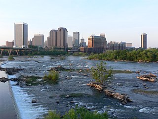
The Greater Richmond Region, the Richmond metropolitan area or Central Virginia, is a region and metropolitan area in the U.S. state of Virginia, centered on Richmond. The U.S. Office of Management and Budget (OMB) defines the area as the Richmond, VA Metropolitan Statistical Area, a Metropolitan Statistical Area (MSA) used by the U.S. Census Bureau and other entities. The OMB defines the area as comprising 17 county-level jurisdictions, including the independent cities of Richmond, Petersburg, Hopewell, and Colonial Heights. As of 2016, it had a population of 1,263,617, making it the 45th largest MSA in the country.

Port Richmond is a neighborhood in the River Wards section of Philadelphia, Pennsylvania. It is notable for its extremely large Polish immigrant and Polish American community. The neighborhood is also home to a large Irish American community and sizable German and Italian communities as represented in the various churches and organizations. In more recent years, a sizable Albanian community has moved in. The Richmond Zip Code is 19134 and 19125.

Amissville is an unincorporated community in Rappahannock County in the U.S. state of Virginia. It is located on U.S. Route 211 about halfway between Warrenton and the small town of Washington, Virginia.

State Route 16 is a primary state highway in the southwest part of the U.S. state of Virginia. It runs from the North Carolina border at North Carolina Highway 16 north to the West Virginia border at West Virginia Route 16, passing through the towns of Troutdale, Marion, and Tazewell. Highway 16 is part of a three-state route 16 that connects the Charlotte region with northwestern West Virginia.
Browne State Forest is a 129-acre (52 ha) state forest in Essex County, Virginia. It is located on Virginia's coastal plain, approximately 10 miles (16 km) southeast of Tappahannock, and 45 miles (72 km) northeast of Richmond.
The Gibraltar Range is a mountain range in the Northern Tablelands region of New South Wales, Australia. The range extends off the Great Dividing Range at Bald Nob about 25 kilometres (16 mi) east northeast of Glen Innes and trends generally east northeast and north northeast for about 100 kilometres (62 mi) to the junction of Timbarra and Clarence rivers. It forms the watershed between these two rivers.

The River Wards is a section of Philadelphia, Pennsylvania, United States located along the Delaware River to the northeast of Center City Philadelphia. 'River Wards' is the commonly used name for an area including several neighborhoods, such as Fishtown, Kensington, Port Richmond and Olde Richmond. The River Wards are located at the border of North Philadelphia and Northeast Philadelphia, and may be considered part of one or the other, or as a separate entity. The area is sometimes also known as 'Bridesburg-Kensington-Richmond'.

The Back Creek, a perennial stream of the Richmond River catchment, is located in Northern Rivers region in the state of New South Wales, Australia.
The Shannon Brook, a perennial stream of the Richmond River catchment, is located in Northern Rivers region in the state of New South Wales, Australia.

The Bryant Range is a range of low mountains in the northern South Island of New Zealand. They form part of the boundary of the Nelson and Tasman Districts with Marlborough Region, as well as forming the western boundary of Mount Richmond Forest Park The range is traversed by State Highway 6 at the Rai Saddle close to its northern end.
Olde Richmond is a neighborhood in the River Wards section of Philadelphia, Pennsylvania. It is notable for its historically large Polish immigrant, Polish American community, and Irish American community. The U.S. ZIP Code for Olde Richmond is 19125 and its post office is located at 1602 Frankford Avenue.
Bramley Mountain is a mountain located in the Catskill Mountains of New York east-northeast of Delhi. Bovina Mountain is located northeast of Bramley Mountain. The mountain is the former location of fire observation tower, which was removed in 1975. The family that purchased and removed it from the mountain has kept the tower in storage since. In January 2020, Friends of Bramley Mountain group was formed. The family plans to give the tower to the group so it can be placed back at its original location.
Bump Mountain is a mountain located in the Catskill Mountains of New York northeast of Ashland. Richtmyer Peak is located north-northeast, The Knob is located west, and Ashland Pinnacle is located west-southwest of Bump Mountain.
Richtmyer Peak is a mountain in Greene County, New York and partly in Schoharie County, New York. It is located in the Catskill Mountains southwest of West Durham. Mount Pisgah is located east, and Richmond Mountain is located southwest of Richtmyer Peak.

