Rusk Mountain

Last updated
Rusk Mountain
Rusk Mountain from Buck Ridge Lookout on West Kill Mountain, Spruceton, NY.jpg
Rusk in autumn from near the summit
of neighboring West Kill Mountain
Highest point
Elevation 3,680 feet (1,125 m) [1]
Prominence 760 feet (230 m) [2]
Listing Catskill High Peaks 21st
Coordinates 42°12′02″N74°16′37″W / 42.20056°N 74.27694°W / 42.20056; -74.27694 Coordinates: 42°12′02″N74°16′37″W / 42.20056°N 74.27694°W / 42.20056; -74.27694
Geography
USA New York relief location map.svg
Red triangle with thick white border.svg
Rusk Mountain
Location of Rusk Mountain within New York
Usa edcp relief location map.png
Red triangle with thick white border.svg
Rusk Mountain
Rusk Mountain (the United States)
Location Jewett / Lexington, New York, U.S.
Parent range Catskills
Topo map USGS Lexington
Climbing
Easiest route ridge south of Ox Hollow

Rusk Mountain is a peak located in the towns of Jewett and Lexington in Greene County, New York, United States. At 3,680 feet (1,121 m) in elevation, it is the 20th-highest peak in the Catskill Mountains and considered a member of the Catskill High Peaks. While there is no maintained trail, a bushwhack to the summit is considered relatively easy, and required for membership in the Catskill Mountain 3500 Club.

Contents

Geography

Rusk is the highest peak (and the only High Peak) on what Catskill forest historian Michael Kudish calls the Lexington Range, the northern of two that fork off from nearby Hunter Mountain, the second-highest Catskill peak. Between Rusk and Taylor Hollow, the col between it and Hunter to its east, there is an unnamed 3,640-foot (1,109 m) summit referred to as East Rusk. The range continues to Evergreen and Packsaddle mountains to the west before ending at Lexington.

The mountain is within the Schoharie Creek watershed. Its southern slopes are drained by an unnamed brook that flows down Ox Hollow into Hunter Brook just above where that stream joins the West Kill, which later drains into the Schoharie. The northern slopes drain directly into the Schoharie headwaters just below them. Its runoff helps feed Schoharie Reservoir, part of the New York City water supply system.

While Rusk is dwarfed from the perspective of the Spruceton Valley by 3,880-foot (1,183 m) West Kill Mountain, it is more impressive due to a greater rise from the valley floor. The north face can be glimpsed in its entirety from NY 296 just north of its junction with NY 23A.

That slope rises up steadily and steeply to the summit ridge. The south is marked by Ox Hollow, and the ridge to its south that is the most frequently used approach when climbing the mountain. The summit ridge leads out to a promontory to the south at the head of the ridge.

Much of the mountain is owned by the state of New York, part of its Forest Preserve, and included in what is currently the Hunter Mountain Wild Forest unit of the Catskill Park. A proposed change, however, would upgrade the lands on Rusk and most of its neighboring peaks into a new unit to be called the Hunter-West Kill wilderness area, while preserving a corridor going up Hunter as the Rusk Mountain Wild Forest (although Rusk would not be a part of that). The only large private landholding on the slopes is to the southwest.

History

Rusk was named by Arnold Henri Guyot after Samuel Rusk, who assisted the Princeton geology professor on what would be the first accurate survey of the Catskills in the 1870s and '80s. There is some evidence, however, that Guyot meant to name what is today East Rusk after Rusk and save Evergreen for today's Rusk, but got confused with his maps.

Guyot made probably what is the first recorded ascent of the mountain during his survey, but it is unknown whether anyone else had come first.

Natural history

According to Kudish, Rusk boasts, in the upper reaches of Ox Hollow, one of the few virgin stands of Eastern Hemlock he has so far identified in the Catskills. This suggests that the barkpeelers of the late 19th century, who deforested large tracts of the region looking for tannin, never got up to this area. The peak was, however, definitely well-explored by the local lumber industry, as skid and wood roads can be found in the woods today, some well above 3,000 feet (900 m) in elevation. The forest below that elevation is thus dominated by the beech and maple trees that are common second-growth in the Catskills.

Above those elevations, those trees persist, albeit in smaller and more stunted forms as elevation increases, until finally they share the summit ridge with the red spruce and balsam fir of the boreal forest found on Catskill summits. Rusk's, however, is more open and passable than some of its neighbors.

Approaches

Land ownership and existing roads in the area have long favored the popular southern approach up the ridge leading up to the summit from Ox Hollow, although easier approaches are theoretically possible. Altogether, there are four routes up the mountain.

Ox Hollow

Hikers taking this route park at the Spruceton trailhead along Spruceton Road (Greene County Route 7) six miles (9.6 km) east of NY 42 at West Kill. They follow the Spruceton Trail, the old road to the fire tower on Hunter, for roughly 0.5 mile (900 m) until it makes a sharp curve shortly after crossing Hunter Brook.

At that point, an old wood road can be seen intersecting from the southwest. This is followed, making for easy crossings of Hunter's unnamed tributary and the intermittent Ox Hollow drainage brook. A short distance afterward it is at the center of the ridge.

From this point, it is very easy to follow the wide ridge's line straight up to the promontory. A stone wall left over from past attempts to farm this land runs nearly parallel to the route at first, and then it is necessary to either cut across a corner of private property or drop slightly down into the Ox Hollow side to remain on public land. Most hikers choose the former.

The woods here remain fairly open, although stinging nettles flourish here in wetter summers. Above approximately 3,200 feet (975 m), after the last wood road has been crossed and the land belongs to the state once again, the climb becomes more difficult. Not only does the slope becomes steeper and rockier, immature seedlings become denser in the forest understory, making it necessary to gently shove them away and duck underneath or step around them.

Hikers who reach the 3,500-foot (1,067 m) cutoff elevation for High Peak status will find themselves at the base of the shale cliffs around the promontory. This is the crux of the Ox Hollow route. While they are not very sheer and present a number of safe routes to a climber willing to use his or her hands, it can take some time to find one and reach the top. A comparatively easy traverse through the cliffs exists, but is not immediately evident, especially in warmer weather when vegetation limits the view.

Once atop the promontory, the ground is level. Climbers who turn due north at this point, towards the obvious higher ground, invariably find the herd path that leads toward the 3500 Club summit canister. At the point where it climbs up onto the summit cap, there is in all seasons of year an excellent view east and southeast toward Kaaterskill High Peak, Hunter and Southwest Hunter. Next to the top of the short scramble, there is a somewhat limited view across the valley to West Kill's summit nunatak.

Total vertical gain via this route is 1,597 feet (487 m). Approximate distance to the summit from Spruceton Road is 2 miles (3.2 km)

Drainage variant

A small number of hikers prefer to follow the creek at the bottom of Ox Hollow instead of the ridge and climb the hollow's steep headwall to the summit or the connecting ridge to East Rusk. This requires more effort later on but avoids the cliffs.

East from Taylor Hollow

When Hunter and Rusk are climbed on the same outing it is common to follow the ridgeline from the Spruceton Trail at Taylor Hollow between the two peaks. This is a gentler rise that also allows for a visit to East Rusk.

Southwest

Since open land, and driveable roads that run off Rusk Mountain Road, climb a good distance up the mountain in this direction it could, if used, provide a relatively easy hike until just before the promontory. However, this land is privately owned and it would be necessary to get permission to cross it.

North face

While this slope is on public land, it is also necessary to get permission to cross private property to reach its base. Some hikers have taken this approach, mainly for variety's sake. Total gain via this route would be 2,180 feet (664 m). There is no herd path in this direction. Some hikers report views to the Blackhead Range exist but are not significantly different or better than the many found in more accessible locations.

Summit

Hunter Mountain from near Rusk's summit, in wintertime Rusk Mountain Summit.jpg
Hunter Mountain from near Rusk's summit, in wintertime

As with many other Catskill peaks, it is difficult to determine where the true high ground on Rusk is as the top is fairly flat. The herd path from the promontory is fairly strong (though some sections near its start can be almost imperceptible in summer when the surrounding ferns grow waist-high) and gets wider and easier to follow as it gets closer to the canister, located near the northwest corner of the summit. There is ample room for a party of hikers to relax and have lunch around it, as many do.

There are few views that equal the viewpoint early on the herd path, though some limited ones to West Kill and its neighbors are available for those who search around in the brush south of the canister, especially if leaves are down.

Anecdotal accounts from GPS readouts on the summit suggest that the mountain may be higher than officially reported.

Related Research Articles

Hunter Mountain (New York) Highest mountain in Greene County, New York, and second highest in the Catskills

Hunter Mountain is in the towns of Hunter and Lexington, just south of the village of Hunter, in Greene County, New York, United States. At approximately 4,040 feet (1,231 m) in elevation, it is the highest peak in the county and the second-highest peak in the Catskill Mountains.

Long Path Hiking trail from George Washington Bridge to Mohawk River valley in upstate New York

The Long Path is a 357-mile (575 km) long-distance hiking trail beginning in New York City, at the West 175th Street subway station near the George Washington Bridge and ending at Altamont, New York, in the Albany area. While not yet a continuous trail, relying on road walks in some areas, it nevertheless takes in many of the popular hiking attractions west of the Hudson River, such as the New Jersey Palisades, Harriman State Park, the Shawangunk Ridge and the Catskill Mountains. It offers hikers a diversity of environments to pass through, from suburbia and sea-level salt marshes along the Hudson to wilderness and boreal forest on Catskill summits 4,000 feet (1,220 m) in elevation.

Slide Mountain (Ulster County, New York) Highest peak of New Yorks Catskill Mountains

Slide Mountain is the highest peak in the Catskill Mountains of the U.S. state of New York. It is located in the town of Shandaken in Ulster County. While the 4,180-foot (1,270 m) contour line on topographic maps is generally accepted as its height, the exact elevation of the summit has never been officially determined by the U.S. Coast and Geodetic Survey, and many informal surveys suggest the mountain may actually top 4,200 feet above sea level.

Catskill Mountain 3500 Club Peakbagging club for hikers

The Catskill Mountain 3500 Club, incorporated as the Catskill 3500 Club and often just referred to as the 3500 Club, is a peakbagging organization for hikers in the Catskill Mountains of New York. Those wishing to become members must climb all 35 Catskill High Peaks and, in a departure from the requirements of most other such clubs, climb Slide, Blackhead, Balsam and Panther mountains again in winter, which is defined by the Club's by-laws as the period from December 21 to March 21 regardless of the actual occurrences of the winter solstice and vernal equinox in particular years. The Club also awards a separate patch for those who go on to climb all 35 peaks during winter.

Stony Clove Notch Mountain pass in Greene County, New York

Stony Clove Notch is a narrow pass, roughly 2,220 feet in elevation located in the Town of Hunter in Greene County, New York, deep in the Catskill Mountains. It is traversed by New York State Route 214, although in the past the Ulster and Delaware Railroad went through it as well.

Kaaterskill High Peak

Kaaterskill High Peak is one of the Catskill Mountains, located in the Town of Hunter in Greene County, New York, United States. It was once believed to be the highest peak in the entire range, but its summit, at 3,655 feet in elevation, places it only 23rd among the Catskill High Peaks. It is, however, the fourth most prominent peak in the range. Due to its situation as the easternmost High Peak, its summit is just outside the watersheds of New York City's reservoirs in the region.

Devils Path (hiking trail) Mountainous hiking trail in New York States Catskill region

The Devil's Path is a hiking trail in the Greene County section of the Catskill Mountains of New York, sometimes described as one of the more challenging trails in the New York Tri-state area. It goes across the eponymous mountain range and then three other peaks to the west, offering hikers and peakbaggers a chance to reach the summits of five of the 35 Catskill High Peaks. It draws hikers from not just the region but far outside, due to the challenging climbs straight up and down the steep gaps between the four peaks of the range, which often require hikers to use hands as well as feet to pull themselves almost straight up cliffs and through rocky chutes. These climbs, however, lead to views across the Catskill range.

Panther Mountain (New York) Mountain in New Yorks Catskill range that rose from old meteor crater

Panther Mountain is one of the Catskill High Peaks, located in the Town of Shandaken in Ulster County, New York. At approximately 3,720 feet (1,130 m) in elevation, it is the 18th highest in the range. A combination of factors has led some geologists to believe the mountain is on the site of an ancient meteorite impact crater.

Hunter Mountain Fire Tower Historic fire lookout tower in New York, United States

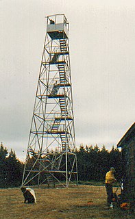
The Hunter Mountain Fire Tower is located on the summit of the eponymous mountain, second highest of the Catskill Mountains in the U.S. state of New York. It was the first of 23 fire lookout towers built by the state in the region, and the next-to-last of the five still standing to be abandoned.

Halcott Mountain

Halcott Mountain is one of the Catskill Mountains of the U.S. state of New York. It is mostly located in Greene County, with some of its lower slopes in Delaware and Ulster counties. Its exact summit elevation has not been officially determined, but the highest contour line on the mountain is 3,520 feet (1,070 m). It is one of the peaks on the divide between the Delaware and Hudson watersheds.

Southwest Hunter Mountain Mountain in United States of America

Southwest Hunter Mountain is a subpeak of Hunter Mountain, located in Greene County, New York. SW Hunter is considered one of the Catskills' High Peaks in its own right, because of its separation from the main summit, and its topographic prominence. Hunter Mountain is named after John Hunter, who also gave his name to the town of Hunter.

Plateau Mountain (New York) High Peak of New Yorks Catskill Mountains with two-mile (3.2 km) summit ridge

Plateau Mountain is located in the town of Hunter in Greene County, New York, United States. It is part of the Devil's Path range of the Catskill Mountains. Plateau has a two-mile-long (3.2 km) summit ridge above 3,500 feet (1,100 m). The highest point, at least 3,840 feet (1,170 m), is at the southeast end, facing Sugarloaf Mountain to the east across Mink Hollow Notch. It is the 12th-highest peak in the range Devils Tombstone is located west of Plateau Mountain. The northwest end faces Hunter Mountain to the west across 1,400-foot deep (430 m) Stony Clove Notch.

Balsam Mountain (Ulster County, New York) 28th highest peak of Catskill Mountains

Balsam Mountain is one of the High Peaks of the Catskill Mountains in the U.S. state of New York. Its exact height has not been determined, so the highest contour line, 3,600 feet (1,100 m), is usually given as its elevation. It is located in western Ulster County, on the divide between the Hudson and Delaware watersheds. The summit and western slopes of the peak are within the Town of Hardenburgh and its eastern slopes are in Shandaken. The small community of Oliverea is near its base on that side. Most of the mountain is publicly owned, managed by the New York State Department of Environmental Conservation as part of the state Forest Preserve, part of the Big Indian-Beaverkill Range Wilderness Area in the Catskill Park. The summit is on a small corner of private land.

Balsam Lake Mountain Westernmost of the Catskill High Peaks in U.S. state of New York

Balsam Lake Mountain is one of the Catskill Mountains, located in the Town of Hardenburgh, New York, United States. It is the westernmost of the range's 35 High Peaks. Its exact height has not been determined, but the highest contour line on topographic maps, 3,720 feet (1,130 m), is usually given as its elevation.

Graham Mountain (New York) Highest privately owned summit in New Yorks Catskill Mountains

Graham Mountain is the seventh highest of the Catskill High Peaks and the highest privately owned mountain in the range. It is located in the town of Hardenburgh, New York, United States.

Red Hill Fire Observation Station United States historic place

The Red Hill Fire Observation Station consists of a fire lookout tower, cabin and pit privy located on the summit of Red Hill, a 2,990-foot (910 m) Catskill Mountain peak in Denning, New York, United States. It is the southernmost fire tower in the Catskill Park.

Catskill Escarpment

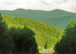
The Catskill Escarpment, often referred to locally as just the Escarpment or the Great Wall of Manitou, and known as the Catskill Front to geologists, is the range forming the northeastern corner of the Catskill Mountains in Greene and Ulster counties in the U.S. state of New York. It rises very abruptly from the Hudson Valley to summits above 3,000 feet (910 m) in elevation, including three of the Catskill High Peaks, with almost no foothills. The plateau to the south and west averages 2,000 feet (610 m) above sea level.

Mount Tremper

Mount Tremper, officially known as Tremper Mountain and originally called Timothyberg, is one of the Catskill Mountains in the U.S. state of New York. It is located near the hamlet of Phoenicia, in the valley of Esopus Creek.

Deep Notch

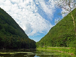
Deep Notch, sometimes West Kill Notch, or Echo Notch, is a mountain pass in Lexington, New York, United States. It divides two Catskill peaks, both subpeaks of high peaks of the range. The narrow groove between the steep, high slopes on either side is traversed by state highway NY 42 and the Shandaken Tunnel, part of the New York City water supply system. It has been called "striking" and "a marvel of grandeur and beauty".

West Kill Tributary of the Schoharie Creek in Greene County, New York

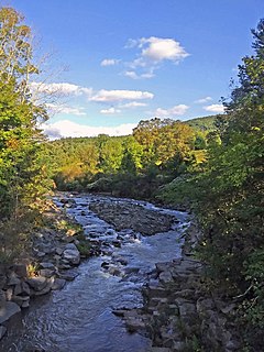
The West Kill, an 11-mile-long (18 km) tributary of Schoharie Creek, flows through the town of Lexington, New York, United States, from its source on Hunter Mountain, the second-highest peak of the Catskill Mountains. Ultimately its waters reach the Hudson River via the Mohawk. Since it drains into the Schoharie upstream of Schoharie Reservoir, it is part of the New York City water supply system. It lends its name to both a mountain to its south and a small town midway along its length.

References

  1. Summit elevation in range between 3,680 and 3,700 feet.
  2. Key col elevation in range between 2,920 and 2,940 feet.