Graham Mountain (New York)

Last updated
Graham Mountain
Graham Mountain from Balsam Lake jeep trail.jpg
Graham from west on old jeep trail to
Balsam Lake Mountain fire tower
Highest point
Elevation 3,868 ft (1,179 m) [1]
Prominence 1,188 ft (362 m) [1]
Listing Catskill High Peaks #7th
Coordinates 42°02′21″N74°32′59″W / 42.0392576°N 74.5495986°W / 42.0392576; -74.5495986 [2]
Geography
USA New York relief location map.svg
Red triangle with thick white border.svg
Graham Mountain
Location of Graham Mountain within New York
Usa edcp relief location map.png
Red triangle with thick white border.svg
Graham Mountain
Graham Mountain (the United States)
Location Hardenburgh, New York
Parent range Catskill Mountains
Topo map USGS Seager
Geology
Age of rock 250-350 mya
Mountain type Mature dissected plateau
Climbing
Easiest route Old road to summit

Graham Mountain is the seventh highest of the Catskill High Peaks and the highest privately owned mountain in the range. [3] It is located in the town of Hardenburgh, New York, United States.

Contents

Its summit is unique in the Catskills for its pygmy hardwood forest cover and absence of evergreen boreal species that normally dominate at that elevation in the range, despite the presence of balsam fir on the slopes below the summit. In the early 1960s a relay station was built there for Instructional Television, a predecessor to today's Public Broadcasting Service. The relay station was abandoned after a few years and its ruins can be seen from the slopes and summits of neighboring peaks.

Graham is within the Catskill Park. Only part of it is in the state-owned Forest Preserve; the summit and the most common access route are owned by descendants of railroad magnate Jay Gould, a native of the region, who closed the peak to the public indefinitely in January 2021. Prior to then, a successful ascent was required for membership in the Catskill Mountain 3500 Club. [4]

Geography

Graham is near the eastern end of the range beginning at Barkaboom Mountain in Delaware County in the west and centered around the lengthy Mill Brook Ridge. [5] A ridge with two summits known unofficially as East and West Schoolhouse mountains connects Graham with Balsam Lake Mountain, the westernmost High Peak. Between Graham and Doubletop, the Catskills' highest trailless peak, to the east is a steep and deep col 900 feet (270 m) below the summits on either side. [6]

The slopes of the mountain on the north and south alternate between steep hollows carved out by creeks and gentler hollows between them. The largest is Drury Hollow on the north, drained by an unnamed brook that rises far down the slopes. Flatiron Brook to the northeast drains a narrower, unnamed valley. The northwest slopes form the southern wall of Turner Hollow, also drained by an unnamed brook. All three are tributaries of Dry Brook, itself a short tributary of the East Branch of the Delaware River. [6] Since Dry Brook drains into the East Branch above Pepacton Reservoir, this puts the north slope of the mountain within New York City's water supply system.

The southern slopes are gentler, draining to the higher plateau around the headwaters of the Beaver Kill, which itself rises just south of the Doubletop col. Gulf of Mexico Brook drains a narrow valley on the southwest, and Tunis and Vly ponds near the mountain's base also feed the Beaver Kill. [6] The Beaver Kill also, eventually, drains into the East Branch at East Branch, below the reservoir and thus outside of the city watershed.

U.S. Geological Survey map of Graham Mountain showing most common access route. Blue is Dry Brook Ridge Trail; brown is old road to summit Graham Mountain map.png
U.S. Geological Survey map of Graham Mountain showing most common access route. Blue is Dry Brook Ridge Trail; brown is old road to summit

Graham's L-shaped summit ridge is narrow, with its spurs pointing northwest and southwest. The United States Geological Survey benchmark indicating the mountain's 3,868-foot (1,179 m) height of land is at the northwest end, near the ruins of the relay station. The southwest end descends gently to 3,660 feet (1,120 m) before dropping off more steeply into the Doubletop col. [6]

The north slopes and most of the summit are within a large tract of land purchased by George Jay Gould I, the son of Jay Gould, a native of nearby Roxbury. Known as Furlow Lodge, it still is owned by the Gould descendants and serves as a family retreat. [7] The south slopes, up to almost 3,500 feet (1,100 m) on the summit ridge's southwest spur, are publicly owned Forest Preserve in the Big Indian-Beaverkill Range Wilderness Area. [8]

Flora and fauna

Most of Graham's slopes, given their high base elevation, are covered in northern hardwood forest of beech, birch and maple. Unlike the other peaks in the range, first-growth forest begins well above 3,000 feet (910 m), as high as 3,545 feet (1,081 m) on one slope. The summit itself is covered with a pygmy forest, unique in the Catskills, with its black cherry and mountain ashes barely taller than average human height. [9] Balsam fir, which dominates the summits of both Doubletop and Balsam Lake mountains to either side of Graham, is found in small stands on the slopes below the summit of Graham. [10]

Catskill forest historian Michael Kudish has studied the range's balsam fir distribution patterns. There are no other peaks where balsam fir occurs on the slopes of the peak, but not the summit, and factors such as elevation, soil, and topography do not suffice to explain the phenomenon. He has concluded that all peaks represent different stages of forest evolution, in which the stunted and twisted ridge hardwoods gradually have replaced balsam fir over the last 8,500 years. [10]

The forests on the mountain support a typical animal community for the Catskills. Black bear and white-tailed deer are the larger mammal species, with many species of rodent, such as snowshoe hare, lower on the food chain. Beavers have been common over the years, with Kudish finding more evidence of present and past dams and meadows on the slopes of Graham and its neighboring peaks. [11]

History

The Catskills were formed 250-350 million years ago, during the Devonian and Silurian periods, when the sands and silt that had eroded from the Acadian Mountains to the northeast collected in a river delta at the mouth of the shallow inland sea that is now the Allegheny Plateau. The delta uplifted as a single unit and gradually streams eroded valleys, creating a dissected plateau. The harder, younger shale and sandstone remains as the mountain summits. Later glaciation made the valleys steeper and smoother. [12]

As with most other peaks in the Mill Brook Ridge range, there was very little human impact on Graham for most of its recorded history. That changed drastically after the construction of Turner Hollow Road in the late 19th century, connecting Seager with the end of Beaver Kill Road, allowing anglers to reach private fishing clubs on the Beaver Kill headwaters from the Arkville Station on the Ulster and Delaware Railroad. [13] Around 1890 George Gould bought the Furlow Lodge tract, including most of the mountain, since his father had enjoyed fishing at the lake so much. [7]

Turner Hollow Road (rerouted to the west in the late 19th century) made the upper slopes of Graham more accessible to logging operations. Their impact on the mountain still is visible to elevations of well above 3,000 feet (910 m), well above their extent elsewhere in the area. One of the last of these took place in the early 1960s, when the relay station was built on a one-acre (4,000 m2) clearing at the summit. [14] A technician and pilot were marooned on the summit for 24 hours after their helicopter crashed there on a maintenance trip during a heavy snowstorm in early 1963. [15] It remained in service for a few more years after that and was abandoned sometime before 1969. [16]

Access

The most frequent route to the summit follows the Dry Brook Ridge Trail from the Mill Brook Road crossing, the highest trailhead in the Catskills at 2,580 feet (790 m). Hikers follow the blue-blazed trail, the old jeep road to the Balsam Lake Mountain fire tower, 1.8 miles (2.9 km) to where the unblazed Old Tappan Road, a relocated stretch of the Turner Hollow Road, forks off to the left at an elevation of 3,340 feet (1,020 m). [3]

At this point hikers leave the trail and its public easement. Permission is required from the Furlow Lodge caretaker to climb from there to the summit of Graham since it is private property; as of January 2021 this is no longer granted since too few hikers had been asking. [4] The Old Tappan Road curves around the side of Turner Hollow, descending 100 feet (30 m) before ascending again after a fork where an older portion of the Turner Hollow Road descends on the left to Drury Hollow. The road ahead continues the gentle ascent until 3,400 feet (1,000 m), where it climbs more sharply up a series of switchbacks, passing some of the balsam firs on the slope at higher elevations. [3]

The summit is marked by a U.S. Geological Survey benchmark with the 3,868-foot (1,179 m) elevation set in a rock at the west edge of the ridge where the road ends. The old relay station, a one-story cinderblock structure with no remaining roof and the three steel supports that can be seen from various viewpoints in the area near the mountain, is at the center of a large clearing. An informal poll of 3500 Club members has found Graham ranks with nearby Eagle as their least favorite summit among the Catskill High Peaks. [9]

There are open views west to Balsam Lake Mountain. Rough use paths lead along the ridge through the pygmy forest to views over the Dry Brook valley and Big Indian, Eagle and Fir mountains to the northwest, and Doubletop and the Beaver Kill's headlands to the southeast. [3]

Other access routes include a bushwhack approach from the Seager-Big Indian Trail along Dry Brook; this usually is combined with an ascent of Doubletop. [4] It also has been hiked in combination with Balsam Lake, for which the hike sometimes begins from the south, at the end of Beaverkill Road north of Quaker Clearing. A direct off-trail hike from there is also possible.

See also

Related Research Articles

<span class="mw-page-title-main">Catskill High Peaks</span> Mountains in New York, United States

The Catskill High Peaks are all of the mountains in New York's Catskill Mountains above 3,500 ft (1,067 m) in elevation whose summits are separated either by one-half mile (0.8 km) or a vertical drop of at least 250 ft (76.2 m) between it and the next nearest separate summit. By usual standards, these mountains are rather low and rounded, and mostly covered by vegetation.

<span class="mw-page-title-main">Hunter Mountain (New York)</span> Highest mountain in Greene County, New York, and second highest in the Catskills

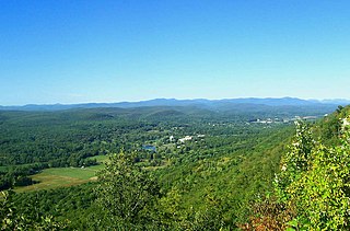
Hunter Mountain is in the towns of Hunter and Lexington, just south of the village of Hunter, in Greene County, New York, United States. At approximately 4,040 feet (1,231 m) in elevation, it is the highest peak in the county and the second-highest peak in the Catskill Mountains.

<span class="mw-page-title-main">Slide Mountain (Ulster County, New York)</span> Highest peak of New Yorks Catskill Mountains

Slide Mountain is the highest peak in the Catskill Mountains of the U.S. state of New York. It is located in the town of Shandaken in Ulster County. While the 4,180-foot (1,270 m) contour line on topographic maps is generally accepted as its height, the exact elevation of the summit has never been officially determined by the U.S. National Geodetic Survey or its predecessors, and many informal surveys suggest the mountain may actually top 4,200 feet (1,280 m) above sea level.

<span class="mw-page-title-main">Stony Clove Notch</span> Mountain pass in Greene County, New York

Stony Clove Notch is a narrow pass, roughly 2,220 feet in elevation located in the Town of Hunter in Greene County, New York, deep in the Catskill Mountains. It is traversed by New York State Route 214, although in the past the Ulster and Delaware Railroad went through it as well.

<span class="mw-page-title-main">Kaaterskill High Peak</span> Mountain in United States of America

Kaaterskill High Peak is one of the Catskill Mountains, located in the Town of Hunter in Greene County, New York, United States. It was once believed to be the highest peak in the entire range, but its summit, at 3,655 feet (1,114 m) in elevation, places it only 23rd among the Catskill High Peaks. It is, however, the fourth most prominent peak in the range. Due to its situation as the easternmost High Peak, its summit is just outside the watersheds of New York City's reservoirs in the region.

<span class="mw-page-title-main">Rusk Mountain</span> Mountain in New York, United States

Rusk Mountain is a peak located in the towns of Jewett and Lexington in Greene County, New York, United States. At 3,680 feet (1,120 m) in elevation, it is the 20th-highest peak in the Catskill Mountains and considered a member of the Catskill High Peaks. While there is no maintained trail, a bushwhack to the summit is considered relatively easy, and required for membership in the Catskill Mountain 3500 Club.

<span class="mw-page-title-main">Panther Mountain (New York)</span> Mountain in New Yorks Catskill range that rose from old meteor crater

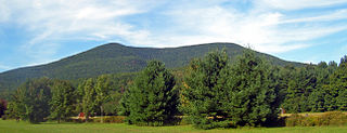
Panther Mountain is one of the Catskill High Peaks, located in the Town of Shandaken in Ulster County, New York. At approximately 3,720 feet (1,130 m) in elevation, it is the 18th highest in the range. A combination of factors has led some geologists to believe the mountain is on the site of an ancient meteorite impact crater.

<span class="mw-page-title-main">Hunter Mountain Fire Tower</span> Historic fire lookout tower in New York, United States

The Hunter Mountain Fire Tower is located on the summit of the eponymous mountain, second highest of the Catskill Mountains in the U.S. state of New York. It was the first of 23 fire lookout towers built by the state in the region, and the next-to-last of the five still standing to be abandoned.

<span class="mw-page-title-main">Halcott Mountain</span> Mountain in the Catskill range in U.S. state of New York

Halcott Mountain is one of the Catskill Mountains of the U.S. state of New York. It is mostly located in Greene County, with some of its lower slopes in Delaware and Ulster counties. Its exact summit elevation has not been officially determined, but the highest contour line on the mountain is 3,520 feet (1,070 m). It is one of the peaks on the divide between the Delaware and Hudson watersheds.

<span class="mw-page-title-main">Southwest Hunter Mountain</span> Mountain in United States of America

Southwest Hunter Mountain (Leavitt Peak) is a subpeak of Hunter Mountain, located in Greene County, New York. It is considered one of the Catskills' High Peaks in its own right, because of its separation from the main summit, and its topographic prominence. Hunter Mountain is named after John Hunter, who also gave his name to the town of Hunter.

<span class="mw-page-title-main">Sugarloaf Mountain (Greene County, New York)</span> Mountain located in Greene County, New York

Sugarloaf Mountain is a mountain located in Greene County, New York. The mountain is part of the Devil's Path range of the Catskill Mountains. To the northwest, Sugarloaf is separated from Plateau Mountain by Mink Hollow Notch; to the southeast, Sugarloaf is separated from Twin Mountain by Pecoy Notch.

<span class="mw-page-title-main">Plateau Mountain (New York)</span> High Peak of New Yorks Catskill Mountains with two-mile (3.2 km) summit ridge

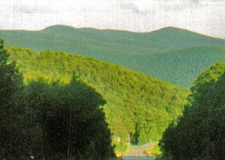
Plateau Mountain is located in the town of Hunter in Greene County, New York, United States. It is part of the Devil's Path range of the Catskill Mountains. Plateau has a two-mile-long (3.2 km) summit ridge above 3,500 feet (1,100 m). The highest point, at least 3,840 feet (1,170 m), is at the southeast end, facing Sugarloaf Mountain to the east across Mink Hollow Notch. It is the 12th-highest peak in the range Devils Tombstone is located west of Plateau Mountain. The northwest end faces Hunter Mountain to the west across 1,400-foot deep (430 m) Stony Clove Notch.

<span class="mw-page-title-main">Balsam Mountain (Ulster County, New York)</span> 28th highest peak of Catskill Mountains

Balsam Mountain is one of the High Peaks of the Catskill Mountains in the U.S. state of New York. Its exact height has not been determined, so the highest contour line, 3,600 feet (1,100 m), is usually given as its elevation. It is located in western Ulster County, on the divide between the Hudson and Delaware watersheds. The summit and western slopes of the peak are within the Town of Hardenburgh and its eastern slopes are in Shandaken. The small community of Oliverea is near its base on that side. Most of the mountain is publicly owned, managed by the New York State Department of Environmental Conservation as part of the state Forest Preserve, part of the Big Indian-Beaverkill Range Wilderness Area in the Catskill Park. The summit is on a small corner of private land.

<span class="mw-page-title-main">Balsam Lake Mountain</span> Westernmost of the Catskill High Peaks in U.S. state of New York

Balsam Lake Mountain is one of the Catskill Mountains, located in the Town of Hardenburgh, New York, United States. It is the westernmost of the range's 35 High Peaks. Its exact height has not been determined, but the highest contour line on topographic maps, 3,720 feet (1,130 m), is usually given as its elevation.

<span class="mw-page-title-main">Wittenberg Mountain</span> Mountain in the United States

Wittenberg Mountain, locally "the Wittenberg'', is a mountain in Ulster County, New York. It is part of the Burroughs Range of the Catskill Mountains. Wittenberg is flanked to the southwest by Cornell Mountain and to the northeast by Terrace Mountain.

Misery Mountain, 2,671 feet (814 m), with at least ten well-defined summits, is a prominent 6 mi (9.7 km) long ridgeline in the Taconic Mountains of western Massachusetts and adjacent New York. The west side of the mountain is located in New York; the east side and high point lie within Massachusetts. The summit ridge is part meadow and part wooded with red spruce, balsam fir, and northern hardwood tree species. It is notable for its views of the Hudson River Valley to the west. The 35 mi (56 km) Taconic Crest Trail traverses the crest of the ridgeline, but does not cross the summit.

<span class="mw-page-title-main">Red Hill Fire Observation Station</span> United States historic place

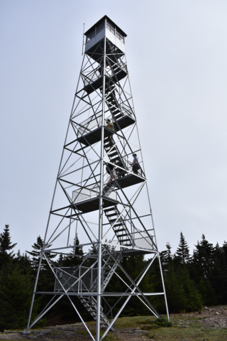
The Red Hill Fire Observation Station consists of a fire lookout tower, cabin and pit privy located on the summit of Red Hill, a 2,990-foot (910 m) Catskill Mountain peak in Denning, New York, United States. It is the southernmost fire tower in the Catskill Park.

<span class="mw-page-title-main">Catskill Escarpment</span> Mountain range in New York, U.S.

The Catskill Escarpment, often referred to locally as just the Escarpment or the Great Wall of Manitou, and known as the Catskill Front to geologists, is the range forming the northeastern corner of the Catskill Mountains in Greene and Ulster counties in the U.S. state of New York. It rises very abruptly from the Hudson Valley to summits above 3,000 feet (910 m) in elevation, including three of the Catskill High Peaks, with almost no foothills. The plateau to the south and west averages 2,000 feet (610 m) above sea level.
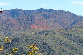
<span class="mw-page-title-main">Mount Tremper</span> Mountain in U.S. state of New York

Mount Tremper, officially known as Tremper Mountain and originally called Timothyberg, is one of the Catskill Mountains in the U.S. state of New York. It is located near the hamlet of Phoenicia, in the valley of Esopus Creek.

<span class="mw-page-title-main">Balsam Lake Mountain Fire Observation Station</span> Former fire lookout tower in the Catskill Mountains of New York, USA

The Balsam Lake Mountain Fire Observation Station is located at the summit of the mountain of that name in the Town of Hardenburgh, New York, United States. It comprises a steel frame fire lookout tower, the observer's cabin and privy and the jeep road to the complex.

References

  1. 1 2 "Graham Mountain, New York". Peakbagger.com. Retrieved 2012-12-18.
  2. "Graham Mountain". Geographic Names Information System . United States Geological Survey, United States Department of the Interior . Retrieved 2012-12-18.
  3. 1 2 3 4 McAllister, Lee; Ochman, Myron (1989). Hiking the Catskills. New York: New York-New Jersey Trail Conference. pp. 254–56. ISBN   0-9603966-6-7.
  4. 1 2 3 "Graham Mountain; Trail-less Peak; Dry Brook Ridge Trail". Catskill Mountain 3500 Club. 2007–2010. Archived from the original on April 20, 2010. Retrieved March 11, 2010.
  5. Kudish, Michael (2000). The Catskill Forest: A History. Fleischmanns, New York: Purple Mountain Press. p. 91. ISBN   1-930098-02-2.
  6. 1 2 3 4 Seager Quadrangle - New York - Delaware and Ulster Counties (Map). 1:24,000. 7½ Minute Series (Topographic). United States Geological Survey. 1940. Retrieved March 1, 2010.
  7. 1 2 Renehan, Ed Jr. (April 2005). "Jay Gould's Roxbury". Guide. Catskill Mountain Foundation . Retrieved March 11, 2010. Another local Gould is Jay's great-grandson Kingdon Gould, Jr., the grandson of George Gould. A Yale-educated attorney and longtime developer of real-estate in the Washington, D.C. area, Kingdon spends his summers at George Gould's Furlow Lodge in nearby Arkville, where he is surrounded by several other Gould homes ...
  8. Central Catskill Trails (Map) (8th ed.). 1:63,360. Cartography by Koch, Ted and Benjamin, Sheryl. New York – New Jersey Trail Conference. 2005. § 6G. ISBN   1-880775-46-8.
  9. 1 2 Kudish, 96.
  10. 1 2 Kudish, 23.
  11. Kudish, 91–92.
  12. Titus, Robert (1993). The Catskills: A Geological Guide. Fleischmanns, New York: Purple Mountain Press. pp. 22–34. ISBN   0-935796-40-1.
  13. Kudish, 92–93.
  14. Kudish, 94.
  15. Dobinsky, Pete (January 5, 1963). "Just Got Hungry ... Watched TV, Says Oneontan Taken Off Catskill Peak" (PDF). Press & Sun-Bulletin . Gannett . Retrieved March 22, 2010.
  16. Kudish, 95. "When I first visited Graham Mountain in 1969, the tower had already been abandoned."