
The West Canada Creek is a 76-mile-long (122 km) river in upstate New York, United States. West Canada Creek is an important water way in Hamilton, Oneida, and Herkimer counties, draining the south part of the Adirondack Mountains before emptying into the Mohawk River near the Village of Herkimer. The name "Canada" is derived from an Iroquoian word for "village" (Kanata).

Beacon Mountain, locally Mount Beacon, is the highest peak of Hudson Highlands, located south of City of Beacon, New York, in the Town of Fishkill. Its two summits rise above the Hudson River behind the city and can easily be seen from Newburgh across the river and many other places in the region. The more accessible northern peak, at 1,516 feet (462 m) above sea level, has a complex of radio antennas on its summit; the 1,595 feet (486 m) southern summit has a fire lookout tower, which was built in 1931.

Lyon Mountain is a 3,820 ft (1,160 m) mountain located in Clinton County, New York, the county’s high point. It is named for Nathaniel Lyon, an early settler of the area who moved from Vermont in 1803 and died circa 1850. The mountain is within New York's Adirondack Park.
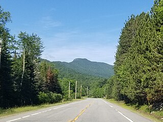
Snowy Mountain is a mountain located in Hamilton County, New York. Initially known as 'Squaw Bonnet', its summit is the highest point in the county. While most maps show the elevation as 3899 feet, some suggest that more recent surveys have it as 3904 feet or even 3908 feet.
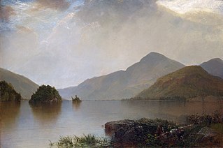
Black Mountain is a mountain located in Washington County, New York, of which its peak is the highest point. Isolated from the rest of the Adirondack Mountains by Lake George, Black Mtn. has the seventh highest topographic prominence of all the mountains in New York. Black Mountain also has the highest elevation of any of the peaks which surround Lake George and offers unobstructed views of the lake from its summit.
Gore Mountain is a mountain located near the village of North Creek in Warren County, New York, of which its peak is the highest point. Gore is flanked to the north by South Mountain, and to the southwest by Height of Land Mountain. The mountain is the site of the popular Gore Mountain ski resort. The mountain is the site of the Gore Mountain Fire Observation Station which was built in 1918.
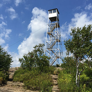
Hadley Mountain is a mountain located in the southern Adirondacks in the U.S. state of New York and is the second-highest peak in Saratoga County after neighboring Tenant Mountain. The Hadley Mountain Fire Observation Station was listed on the National Register of Historic Places on September 23, 2001 for its role as a Fire lookout tower with the New York State Forest Preserve. Hadley Mountain is the highest of the three peaks that form the West Mountain ridge.
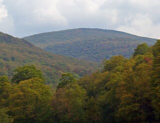
Balsam Lake Mountain is one of the Catskill Mountains, located in the Town of Hardenburgh, New York, United States. It is the westernmost of the range's 35 High Peaks. Its exact height has not been determined, but the highest contour line on topographic maps, 3,720 feet (1,130 m), is usually given as its elevation.

Alander Mountain is a 2,241-foot-tall (683 m) part of the south Taconic Mountains in southwest Massachusetts and adjacent to New York. The summit is grassy and covered with scrub oak and shrubs; the sides of the mountain are heavily forested. Several trails traverse Alander Mountain, most notably is the 15.7 mi (25.3 km) South Taconic Trail, which passes just beneath the summit.
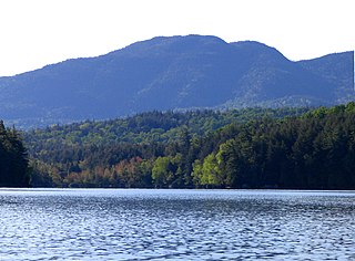
Ampersand Mountain is a 3,352 ft (1,021.7 m) mountain in Franklin County in the High Peaks Wilderness Area of the northeastern Adirondacks, west of the High Peaks proper in New York State. The trail up the mountain begins on New York State Route 3 8.1 miles (13.0 km) southwest of the village of Saranac Lake, near Middle Saranac Lake; it is a popular day hike. The mountain takes its name from nearby Ampersand Creek, so named because it twists and turns like the ampersand symbol. The summit is bare rock, with extensive views of the High Peaks to the east and the Saranac Lakes to the west. Stony Creek Mountain is located west-southwest of Ampersand Mountain. The mountain is notable as the land surrounding its hiking trail's initial ascent is generally acknowledged as unlogged old growth forest.

The Balsam Lake Mountain Fire Observation Station is located at the summit of the mountain of that name in the Town of Hardenburgh, New York, United States. It comprises a steel frame fire lookout tower, the observer's cabin and privy and the jeep road to the complex.
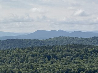
Owls Head Mountain is a 2,786-foot-tall (849 m) mountain in the Adirondack Mountains region of New York. It is located west-southwest of the hamlet of Long Lake in Hamilton County.

Vanderwhacker Mountain is a 3,389-foot-tall (1,033 m) mountain in the Adirondack Mountains region of New York. It is located northeast of Indian Lake and southeast of Newcomb in Essex County. The Vanderwhacker Mountain Fire Observation Station is located on top of the mountain. In May 1911, the Conservation Commission built a wooden fire observation tower on the mountain which was replaced in 1918, with a 35-foot-tall (11 m) metal tower. The tower stopped fire watching operations at the end of the 1988 season.
Hamilton Mountain is a 3,215-foot-tall (980 m) summit located in Adirondack Mountains of New York. It is located in the west-northwest of the hamlet of Wells in Hamilton County. In 1909, a wood fire lookout tower was built on the mountain. In 1916, the wood tower was replaced with a 50-foot-tall (15 m) steel tower. Due to aerial fire detection being better, the tower was closed at the end of the 1971 fire lookout season, and removed a few years later.

Mount Morris is a 3,117-foot-tall (950 m) mountain located in Adirondack Mountains of New York. It is located in the south-southwest of the village of Tupper Lake in Franklin County, and is "the highest peak immediately east of Tupper Lake." It is named after the town in which it was then located.
West Mountain is a 2,923-foot-tall (891 m) mountain located in Adirondack Mountains of New York. It is located in the northwest of the hamlet of Raquette Lake in Hamilton County. In 1920, the Conservation Commission built a 47-foot-tall (14 m) fire lookout tower on the mountain. Due to aerial detection, the tower ceased fire lookout operations at the end of the 1970 season. The tower was later removed, and portions of the tower along with the tower from Kempshall Mountain were used to build the tower that is at the Essex County Historical Museum in Elizabethtown.
Salmon Lake Mountain is a 2,500-foot-tall (760 m) summit located in Adirondack Mountains of New York. It is located west of the hamlet of Long Lake in Hamilton County. Around 1933, a 35-foot-tall (11 m) Aermotor LX24 tower was built on the mountain. The tower was privately owned, but cooperated with the Conservation Commission for fire watching operations. The tower still remains, but is in poor condition and is not open to the public.

Utsayantha Mountain is a 3,209-foot-tall (978 m) mountain in the Catskill Mountains of New York. It is located east-southeast of Stamford in Delaware County. Variant names include Utsayanthe Mountain, Utsayanthia Mountain, Utsayantho Mountain, and Utsyantha Mountain. McGregor Mountain is located southeast of Utsayantha Mountain and Churchill Mountain is located southwest. Utsayantha Mountain is named after Utsayantha, the daughter of Chief Ubiwacha, chief of the Lenape Indians.
T Lake Mountain is a mountain in the Adirondack Mountains region of New York. It is located north-northwest of Witherbee in Hamilton County. In 1916, the Conservation Commission built a 50-foot-tall (15 m) Aermotor LL25 tower on the mountain. The T Lake Mountain Fire Observation Station ceased fire watching operations at the end of the 1970 season. In 1977, U.S. Army Engineers tested explosive charges on the fire tower which brought the tower crashing down. A few weeks later, the remains of the tower were removed by helicopter.

Kempshall Mountain is a 3,350-foot-tall (1,020 m) mountain located in Adirondack Mountains of New York. It is located in the northwest of the hamlet of Long Lake in Hamilton County. In 1918, a 35-foot-tall (11 m) Aermotor LS40 tower was built on the mountain for fire lookout purposes. Due to aerial detection being used, the tower ceased fire lookout operations at the end of the 1971 season. The tower was later removed, and portions of the tower along with the tower from West Mountain were used to build the tower that is at the Essex County Historical Museum in Elizabethtown.


