
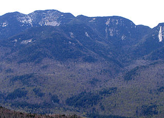
Mount Marcy is the highest point in the U.S. state of New York, with an elevation of 5,343.1 feet (1,628.6 m). It is located in the town of Keene in Essex County. The mountain is in the heart of the High Peaks Wilderness Area in Adirondack Park. Like the surrounding Adirondack Mountains, Marcy was heavily affected by large glaciers during recent ice ages, which deposited boulders on the mountain slopes and carved valleys and depressions on the mountain. One such depression is today filled by Lake Tear of the Clouds, which is often cited as the highest source of the Hudson River. The majority of the mountain is covered by hardwood and spruce-fir forests, although the highest few hundred feet are above the tree line. The peak is dominated by rocky outcrops, lichens, and alpine plants. The mountain supports a diverse number of woodland mammals and birds.

Mount Skylight is a mountain in the Adirondacks in the U.S. state of New York. Skylight is the fourth highest peak in New York, with an elevation of 4,924 feet (1,501 m), and one of the 46 High Peaks in Adirondack Park. It is located in the town of Keene in Essex County. The mountain was given its name by artist Frederick S. Perkins and guide Orson Schofield Phelps in 1857, due to a rock formation on the peak resembling a window. Phelps would later make the first known ascent of the peak with surveyor Verplanck Colvin and two others on August 28, 1873.
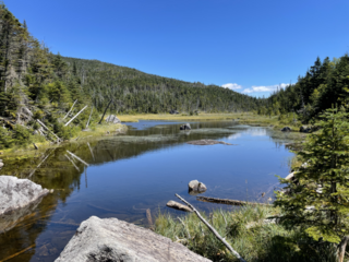
Lake Tear of the Clouds is a small tarn located in the town of Keene, in Essex County, New York, United States, on the southwest slope of Mount Marcy, the state's highest point, in the Adirondack Mountains. It is the highest pond in the state at 4,293 feet (1,309 m). It is often cited as the highest source of the Hudson River, via Feldspar Brook, the Opalescent River and Calamity Brook.

Esther Mountain is a mountain located in Essex County, New York. The mountain is the northernmost of the High Peaks of the Adirondack Mountains and its 28th highest peak. It was the only High Peak named for a woman until 2014, having been named in honor of Esther McComb, who made the first recorded climb to the summit in 1839, at age 15; at the time she was attempting to climb Whiteface Mountain from the north.

Dial Mountain is a mountain located in Essex County, New York. The mountain is part of the Colvin Range. Dial Mountain is flanked to the southwest by Nippletop.
Grace Peak is a mountain located in Essex County, New York. It is part of the Dix Range, named after John A. Dix (1798–1879), New York Secretary of State in 1837, and later Governor. The mountain was formerly called East Dix, but in 2014 it was officially renamed Grace Peak in honor of Grace Hudowalski (1906–2004), who in 1937 became the ninth person and first woman to climb all 46 of the Adirondack High Peaks. Grace Peak is flanked to the northeast by Spotted Mountain, and to the southwest by South Dix.
South Dix is a mountain located in Essex County, New York. The mountain is part of the Dix Range, named after John A. Dix (1798–1879), New York Secretary of State in 1837, and later Governor. The name is being changed to Carson Peak, after Russell M.L. Carson (1884–1961), author of Peaks and People of the Adirondacks. South Dix is flanked to the northeast by Grace Peak, to the northwest by Hough Peak, and to the southwest by Macomb Mountain.
Macomb Mountain is a mountain located in Essex County, New York. The mountain is named after Maj. Gen. Alexander Macomb (1782–1841), who won acclaim during the War of 1812 at the Battle of Plattsburgh, and served as Commanding General of the United States Army (1828–1841).

Hough Peak is a mountain located in Essex County, New York. The mountain, part of the Dix Range, is named after Franklin B. Hough (1822–1885), the first chief of the United States Division of Forestry, and sometimes called the "father of American forestry". Hough Peak is flanked to the north by Dix Mountain, and to the south by South Dix.

Phelps Mountain is a mountain located in Essex County, New York. The mountain is named after Orson Schofield "Old Mountain" Phelps (1817–1905), who cut the first trail up Mount Marcy and named several of the Adirondack peaks. It is the 32nd highest peak in New York. Phelps Mountain is flanked to the southeast by Table Top Mountain.
Table Top Mountain is a mountain located in Essex County in the U.S. State of New York. Table Top Mtn. is flanked to the north by Phelps Mountain, and to the south by Mount Marcy. Table Top has three summits; the southernmost is the highest, followed by the middle peak at 4,308 ft (1,313 m) and the north peak at 4,216 ft (1,285 m).

Allen Mountain is located in Essex County, New York. It is part of the Marcy Group of the Great Range of the Adirondack Mountains, and is flanked to the north by Mount Skylight.
Cliff Mountain is a mountain located in Essex County, New York. The mountain is part of the Marcy Group of the Great Range of the Adirondack Mountains. Cliff is flanked to the southeast by Mount Redfield.
Armstrong Mountain is a mountain located in Essex County, New York, named after Thomas Armstrong, a local pioneer. The mountain is part of the Great Range of the Adirondack Mountains. Armstrong Mtn. is flanked to the southwest by Gothics, and to the northeast by Upper Wolfjaw Mountain.

Lower Wolfjaw Mountain is located in Essex County, New York, United States. Landscape artist Alexander Helwig Wyant (1836–1892) named Lower Wolfjaw, together with neighboring Upper Wolfjaw Mountain, about 1870 for their appearance in profile. The mountain is the northeasternmost of the Adirondack High Peaks in the Great Range of the Adirondack Mountains. Lower Wolfjaw Mountain is flanked to the southwest by Upper Wolfjaw Mountain, and to the northeast by Hedgehog Mountain.
Upper Wolfjaw Mountain is a mountain located in Essex County, New York. Landscape artist Alexander Helwig Wyant (1836–1892) named the mountain, in combination with neighboring Lower Wolfjaw Mountain, c. 1870 for their appearance in profile. The mountain is part of the Great Range of the Adirondack Mountains. Upper Wolfjaw Mtn. is flanked to the southwest by Armstrong Mountain, and to the northeast by Lower Wolfjaw Mtn.
Couchsachraga Peak is a mountain located in Essex County, New York. "Couchsachraga" is based on an Algonquin or Huron name for the area, meaning "dismal wilderness". The mountain is part of the Santanoni Mountains of the Adirondacks. Couchsachraga Peak is flanked to the east by Panther Peak. There is no marked trail to the summit, which, being fully forested, has no views.

Santanoni Peak is a mountain located in Essex County, New York. The mountain is part of the Santanoni Mountains of the Adirondacks. The mountain's name is believed to be an Abenaki derivative of "Saint Anthony"; the first French fur traders and missionaries having named the area for Saint Anthony of Padua. Santanoni Peak is flanked to the north by Panther Peak, and to the southwest by Little Santanoni Mountain.

Donaldson Mountain is a mountain located in Franklin County, New York, named in 1924 after Alfred Lee Donaldson (1866–1923), author of A History of the Adirondacks. The mountain is part of the Seward Mountains of the Adirondacks. Donaldson Mtn. is flanked to the northeast by Seward Mountain, and to the south by Mount Emmons.

Mount Emmons is a mountain located in the Adirondack Mountains near the southern edge of Franklin County, New York, United States.

