
Whiteface Mountain is the fifth-highest mountain in the U.S. state of New York, and one of the High Peaks of the Adirondack Mountains. Set apart from most of the other High Peaks, the summit offers a 360-degree view of the Adirondacks and clear-day glimpses of Vermont and even Canada, where the skyscrapers of Montreal, 80 miles (130 km) away, can be seen on a very clear day. Located in the town of Wilmington, about 13 miles (21 km) from Lake Placid, the mountain's east slope is home to a major ski area with the greatest vertical drop east of the Rockies, which hosted the alpine skiing competitions of the 1980 Winter Olympics. Unique among the High Peaks, Whiteface features a developed summit and seasonal accessibility by motor vehicle. Whiteface Memorial Highway reaches a parking area at an elevation of 4,600 feet (1,400 m), with the remaining 267 feet (81 m) being obtained by tunnel and elevator.

Slide Mountain is the highest peak in the Catskill Mountains of the U.S. state of New York. It is located in the town of Shandaken in Ulster County. While the 4,180-foot (1,270 m) contour line on topographic maps is generally accepted as its height, the exact elevation of the summit has never been officially determined by the U.S. Coast and Geodetic Survey, and many informal surveys suggest the mountain may actually top 4,200 feet above sea level.

Rocky Peak Ridge is the twentieth highest peak in the High Peaks Region of the Adirondack Park of New York, United States. The name of the mountain is due to its geology, a rocky ridge to the east of the better known Giant Mountain. The long, bare ridge is unusual in the Adirondacks; it resulted from the last great forest fire in the region, in 1913.

The Tongue Mountain Range Trails are a series of hiking trails located within the Tongue Mountain Range, a subordinate range within the Adirondack Mountains of New York. The trails, 25 miles (40 km) in total length, vary from easy walks along the foot of the mountains on the shore of adjacent Lake George, to more rugged ascents of mountain peaks within the range.

Esther Mountain is a mountain located in Essex County, New York. The mountain is the northernmost of the High Peaks of the Adirondack Mountains and its 28th highest peak. It was the only High Peak named for a woman until 2014, having been named in honor of Esther McComb, who made the first recorded climb to the summit in 1839, at age 15; at the time she was attempting to climb Whiteface Mountain from the north.

Phelps Mountain is a mountain located in Essex County, New York. The mountain is named after Orson Schofield "Old Mountain" Phelps (1817–1905), who cut the first trail up Mount Marcy and named several of the Adirondack peaks. It is the 32nd highest peak in New York. Phelps Mountain is flanked to the southeast by Table Top Mountain.

Street Mountain is a mountain located in Essex County, New York, named after Alfred Billings Street (1811–1881), a poet and New York State Librarian. The mountain is the high point of the Street Range of the Adirondack Mountains. Street's northeast ridge is Nye Mountain.

Lyon Mountain is a 3,820 ft (1,160 m) mountain located in Clinton County, New York, the county’s high point. It is named for Nathaniel Lyon, an early settler of the area who moved from Vermont in 1803 and died circa 1850. The mountain is within New York's Adirondack Park.
Snowy Mountain is a mountain located in Hamilton County, New York. Initially known as 'Squaw Bonnet', its summit is the highest point in the county. While most maps show the elevation as 3899 feet, some suggest that more recent surveys have it as 3904 feet or even 3908 feet.
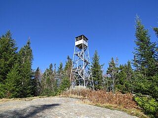
Gore Mountain is a mountain located near the village of North Creek in Warren County, New York, of which its peak is the highest point. Gore is flanked to the north by South Mountain, and to the southwest by Height of Land Mountain. The mountain is the site of the popular Gore Mountain ski resort. The mountain is the site of the Gore Mountain Fire Observation Station which was built in 1918.

Hadley Mountain is a mountain located in the southern Adirondacks in the U.S. state of New York and is the second highest peak in Saratoga County after neighboring Tenant Mountain. The Hadley Mountain Fire Observation Station was listed on the National Register of Historic Places on September 23, 2001 for its role as a Fire lookout tower with the New York State Forest Preserve. Hadley Mountain is the highest of the three peaks that form the West Mountain ridge.

Balsam Lake Mountain is one of the Catskill Mountains, located in the Town of Hardenburgh, New York, United States. It is the westernmost of the range's 35 High Peaks. Its exact height has not been determined, but the highest contour line on topographic maps, 3,720 feet (1,130 m), is usually given as its elevation.
Alander Mountain is a 2,241-foot-tall (683 m) prominent peak of the south Taconic Mountains; it is located in southwest Massachusetts and adjacent New York. Part of the summit is grassy and open and part is covered with scrub oak and shrubs; the sides of the mountain are wooded with northern hardwood tree species. Views from the top include the southern Taconic Mountains, the Hudson River Valley including the Catskills. Several trails traverse Alander Mountain, most notably the 15.7 mi (25.3 km) South Taconic Trail, which passes just beneath the summit.

Ampersand Mountain is a 3,352 ft (1,021.7 m) mountain in Franklin County in the High Peaks Wilderness Area of the northeastern Adirondacks, west of the High Peaks proper in New York State. The trail up the mountain begins on New York State Route 3 8.1 miles (13.0 km) southwest of the village of Saranac Lake, near Middle Saranac Lake; it is a popular day hike. The mountain takes its name from nearby Ampersand Creek, so named because it twists and turns like the ampersand symbol. The summit is bare rock, with extensive views of the High Peaks to the east and the Saranac Lakes to the west. Stony Creek Mountain is located west-southwest of Ampersand Mountain. The mountain is notable as the land surrounding its hiking trail's initial ascent is generally acknowledged as unlogged old growth forest.

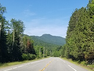
Hurricane Mountain is a 3,688-foot-tall (1,124 m) mountain near Keene in the north of the High Peaks region of the Adirondacks in New York, United States. It is considered to boast some of the most impressive views of any of the lesser peaks; this is due to its prominence, and because its summit was cleared by Verplanck Colvin in the course of his early survey of the Adirondacks. On a clear day, the length of Lake Champlain and the Green Mountains of Vermont are visible to the east, and many of the High Peaks can be seen to the south through the northwest. There is a disused fire tower on the top.

The Red Hill Fire Observation Station consists of a fire lookout tower, cabin and pit privy located on the summit of Red Hill, a 2,990-foot (910 m) Catskill Mountain peak in Denning, New York, United States. It is the southernmost fire tower in the Catskill Park.
Prospect Mountain is a mountain located in the town of Lake George in Warren County, New York. New York State Route 917A, an unsigned reference route also known as Prospect Mountain Veterans Memorial Highway, is a toll road maintained by the New York State Department of Environmental Conservation and is the highway by which one reaches the summit at 5.88 miles (9.46 km), where a view for one hundred miles (160 km) can be seen.

The Balsam Lake Mountain Fire Observation Station is located at the summit of the mountain of that name in the Town of Hardenburgh, New York, United States. It comprises a steel frame fire lookout tower, the observer's cabin and privy and the jeep road to the complex.
Poke-O-Moonshine Mountain, spelled Pokamoonshine on U.S. Geological Survey maps, and sometimes known as just Poke-O, is a minor peak of the Adirondack Mountains. The name is believed to be a corruption of the Algonquin words pohqui, meaning 'broken', and moosie, meaning 'smooth'. It is located in the town of Chesterfield, New York, United States, on New York state Forest Preserve land, part of the Taylor Pond Wild Forest complex within the Adirondack Park. Due to its location next to the pass through which most travelers from the north enter the range, it has been called the "gateway to the Adirondacks".
Owls Head Mountain is a 2,786-foot-tall (849 m) mountain in the Adirondack Mountains region of New York. It is located west-southwest of the hamlet of Long Lake in Hamilton County.


