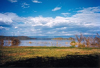
Lake Baringo is, after Lake Turkana, the most northern of the Kenyan Rift Valley lakes, with a surface area of 130 square kilometres (50 sq mi) and an elevation of 970 metres (3,180 ft). The lake is fed by several rivers: the Molo, Perkerra and Ol Arabel. It has no obvious outlet; the waters are assumed to seep through lake sediments into the faulted volcanic bedrock. It is one of the two freshwater lakes in the Rift Valley in Kenya, the other being Lake Naivasha.

Lake Chad is an endorheic freshwater lake located at the junction of four countries: Nigeria, Niger, Chad, and Cameroon in western and central Africa respectively, with a catchment area of 1×10^6 km2 (390,000 sq mi). It is an important wetland ecosystem in West-Central Africa. The lakeside is rich in reeds and swamps, and the plain along the lake is fertile, making it an important irrigated agricultural area. The lake is rich in aquatic resources and is one of the important freshwater fish producing areas in Africa.
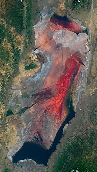
Lake Natron is a salt or alkaline lake located in north Ngorongoro District of Arusha Region in Tanzania at the border with Kenya. It is in the Gregory Rift, which is the eastern branch of the East African Rift. The lake is within the Lake Natron Basin, a Ramsar Site wetland of international significance. It is the only regular breeding area for Africa's lesser flamingoes, although this habitat is not protected and is under threat from planned development projects.

Lake Manyara is a lake located in Monduli District of Arusha Region, Tanzania and is the seventh-largest lake of Tanzania by surface area, at 470-square-kilometre (180 sq mi). It is a shallow, alkaline lake in the Natron-Manyara-Balangida branch of the East African Rift. The northwest quadrant of the lake is included within Lake Manyara National Park and it is part of the Lake Manyara Biosphere Reserve, established in 1981 by UNESCO as part of its Man and the Biosphere Programme.

Lake Bogoria is a saline, alkaline lake that lies in a volcanic region in a half-graben basin south of Lake Baringo, Kenya, a little north of the equator. Lake Bogoria, like Lake Nakuru, Lake Elementeita, and Lake Magadi further south in the Rift Valley, and Lake Logipi to the north, is home at times to one of the world's largest populations of lesser flamingos. The lake is a Ramsar site and Lake Bogoria National Reserve has been a protected National Reserve since November 29, 1973. Lake Bogoria is shallow, and is about 34 km long by 3.5 km wide, with a drainage basin of 700 km2. It is Located in Baringo County.

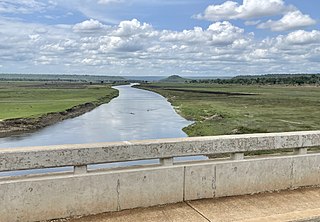
The Mara River is a river in that begins in Narok County (Kenya) and in ends in Mara Region (Tanzania), and lies across the migration path of ungulates in the Maasai Mara/Serengeti ecosystem.

The Peace–Athabasca Delta, located in northeast Alberta, is the largest freshwater inland river delta in North America. It is located partially within the southeast corner of Wood Buffalo National Park, Canada's largest national park, and also spreads into the Regional Municipality of Wood Buffalo, west and south of the historical community of Fort Chipewyan. The delta encompasses approximately 321,200 ha, formed where the Peace and Athabasca rivers converge on the Slave River and Lake Athabasca. The delta region is designated a wetland of international importance and a UNESCO World Heritage Site. The region is large enough that it is considered one of twenty distinct natural subregions of Alberta by the provincial government's Natural Regions Committee.

The Aberdare Range is a 160 km (99 mi) long mountain range of upland, north of Kenya's capital Nairobi with an average elevation of 3,500 metres (11,480 ft). It straddles the counties of Nyandarua, Nyeri, Muranga, Kiambu and Laikipia. The mountain range is located in west central Kenya, northeast of Naivasha and Gilgil and lies just south of the Equator. The mountain range is called Nyandarua among the Agikuyu people in whose territory this forest and mountain range is located. The name Nyandarua comes from the Kikuyu word rwandarua meaning a drying hide, due to the distinctive fold of its silhouette.

The Hadejia-Nguru wetlands in Yobe State in northern Nigeria, which include Nguru Lake, are ecologically and economically important. They are threatened by reduced rainfall in recent years, a growing population and upstream dam construction.

Lake Elmenteita is a soda lake, in the Great Rift Valley, about 120 km northwest of Nairobi, Kenya.

Ewaso Ng'iro, also called Ewaso Nyiro, is a river in Kenya which rises on the west side of Mount Kenya and flows north, then east and finally south-east, passing through Somalia where it joins the Jubba River. The river's name is derived from the local community's language, and means river of brown or muddy water. Downstream, the intermittent stream in Somalia is also called Lagh Dera.

The chestnut-banded plover is a species of bird in the family Charadriidae. This species has a large range, being distributed across Southern Africa. However, it occupies a rather small area.
The Malagarasi River is a river in western Tanzania, flowing through Kigoma Region, although one of its tributaries comes from southeastern Burundi. The river also forms the western border of Tabora Region, the southern border of Kagera Region and the southwestern border of Geita Region. It is the second-longest river in Tanzania behind the Rufiji—Great Ruaha, and has the largest watershed of any river flowing into Lake Tanganyika. The Malagarasi-Muyovozi Wetlands are a designated a Ramsar site. Local tribes have nicknamed the Malagarasi as "the river of bad spirits".

Nguruman Escarpment is an escarpment in southern Kenya. The escarpment is around 50 kilometres long and elongated in the N-W direction. Its northern edge is approximately 120 km southwest of Nairobi, while the southern edge is near the Tanzanian border, at the northwestern corner of Lake Natron. The Southern Ewaso Ng'iro River flows southward along the foot of the escarpment, while Loita Hills are located west of the escarpment. The escarpment forms the western wall of the Great Rift Valley. Below it are the vast plains and the volcanic hills of the Great Rift Valley and in the distance are Lake Magadi and Lake Natron.

Mau Forest is a forest complex in the Rift Valley of Kenya. It is the largest indigenous montane forest in East Africa. The Mau Forest complex has an area of 273,300 hectares.
The Great Rift Valley is part of an intra-continental ridge system that runs through Kenya from north to south. It is part of the Gregory Rift, the eastern branch of the East African Rift, which starts in Tanzania to the south and continues northward into Ethiopia. It was formed on the "Kenyan Dome" a geographical upwelling created by the interactions of three major tectonics: the Arabian, Nubian, and Somalian plates. In the past, it was seen as part of a "Great Rift Valley" that ran from Madagascar to Syria. Most of the valley falls within the former Rift Valley Province.
The Shompole Conservancy is a large privately operated conservation area in the south of the Great Rift Valley, Kenya. It is located between Lake Magadi to the north and Lake Natron to the south, two alkaline lakes.
The Perkerra River is a river in the Great Rift Valley in Kenya that feeds the freshwater Lake Baringo. It is the only perennial river in the arid and semi-arid lands of the Baringo County. The Perkerra river supplies water to the Perkerra Irrigation Scheme in the Jemps flats near Marigat Township, just south of the lake.
Ol Arabel is a river in the Great Rift Valley of Kenya that feeds Lake Baringo. It gives its name to a forest covering its headwaters and to a region.

The Yala River is a river in western Kenya, a tributary of Lake Victoria. It generally flows fast over a rocky bed through a wide valley before joining the Nzoia River to form the Yala Swamp on the border of Lake Victoria. The land along its course is mostly cultivated or used for grazing, with relatively few remnants of the original forest. Soil erosion is visible throughout the river basin, particularly in the lower parts. Projects are underway to exploit the river for hydroelectricity.


