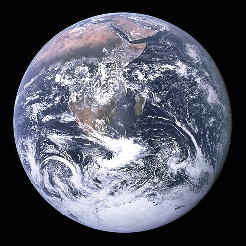
The Blue Marble

Last updated

The Blue Marble, taken by either Ron Evans or Harrison Schmitt of the Apollo 17 crew in 1972. The original photograph was taken with the South Pole facing the top, however this version is the most widely distributed. The Earth seen from Apollo 17.jpg
The Blue Marble, taken by either Ron Evans or Harrison Schmitt of the Apollo 17 crew in 1972. The original photograph was taken with the South Pole facing the top, however this version is the most widely distributed.

The Blue Marble is a photograph of Earth taken on December 7, 1972, from a distance of around 29,400 kilometers (18,300 miles) from the planet's surface. [1]

Contents

The original image (NASA designation AS17-148-22727) was taken by either Ron Evans or Harrison Schmitt of the crew of the Apollo 17 spacecraft on its way to the Moon, and showed the Earth with the south pole facing upwards; since then, a cropped and rotated version has become one of the most reproduced images in history. [2] [3]

It mainly shows Earth from the Mediterranean Sea to Antarctica. This was the first time the Apollo trajectory made it possible to photograph the south polar ice cap, despite the Southern Hemisphere being heavily covered in clouds. In addition to the Arabian Peninsula and Madagascar, almost the entire coastline of Africa and most of the Indian Ocean are clearly visible, a cyclone in the Indian Ocean is also visible, the South Asian mainland is on the eastern limb.

NASA has also applied the name to a 2012 series of images which cover the entire globe at relatively high resolution. These were created by looking through satellite pictures taken over time in order to find as many cloudless photographs as possible to use in the final images. NASA has verified that the 2012 "blue marble" images are composites, made from multiple images taken in low Earth orbit. Likewise, these images do not fit together properly and due to lighting, weather and cloud interference it is impossible to collect cohesive or fully clear images of the entire Earth simultaneously. [4]

The photograph

Color-calibrated version The Blue Marble (remastered).jpg
Color-calibrated version

The photograph, taken on December 7, 1972, [5] is one of the most widely distributed photographic images in existence. [3] The astronauts had the Earth's south pole facing upwards and the Sun above them (in spatial navigation terms, to their zenith) [6] when they took the image. To the astronauts, the Earth had the appearance and size of a glass marble.

History

Context

The Blue Marble was not the first clear color image taken of an illuminated face of Earth, since such images by satellites had already been made and released as early as 1967, [7] and is the second time such a photo was taken by a person after the 1968 photograph Earthrise taken by William Anders of Apollo 8. [8]

Before the Blue Marble a picture of the fully illuminated Earth by the ATS-3 satellite was used in 1968 by Stewart Brand for his Whole Earth Catalog , after campaigning since 1966 to have NASA release a then-rumored satellite image of the entire Earth as seen from space. He got inspired during an LSD trip, seeing a "psychedelic illusion" of the Earth's curvature, convincing him that a picture of the entire planet would change how humans related to it. [9] [10] He sold and distributed buttons for 25 cents each [11] that asked: "Why haven't we seen a photograph of the whole Earth yet?" [12] During this campaign, Brand met Buckminster Fuller, who offered to help Brand with his project. [13] Several of the pins made their way to NASA employees. [10]

The Apollo 17 image, however, released during a surge in environmental activism during the 1970s, became a symbol of the environmental movement, as a depiction of Earth's fragility, vulnerability, and isolation amid the vast expanse of space. [2]

Today, as speculated by NASA archivist Mike Gentry, The Blue Marble is among the most widely distributed images in history. [3]

Circumstances

AS17-148-22727, from which The Blue Marble was cropped Apollo 17 Blue Marble original orientation (AS17-148-22727).jpg
AS17-148-22727, from which The Blue Marble was cropped

The photograph's official NASA designation is AS17-148-22727. [14] It is the third of a series of shots which were taken just before and are nearly identical, NASA photograph AS17-148-22725 [15] and AS17-148-22726, the second also having been used as a full-Earth image. [16] The widely published versions are cropped and chromatically adjusted from the original photographs. [17] [18]

According to the photograph description by NASA it was taken at 05:39 a.m. EST, [8] 5 hours 6 minutes after launch of the Apollo 17 mission, [19] and about 1 hour 54 minutes after the spacecraft left its parking orbit around Earth to begin its trajectory to the Moon. [20] Alternatively, Eric Hartwell has identified it as having been taken slightly earlier at 5 hours 3 minutes, when one crew member states having changed the f-number, presumably between AS17-148-22725, the first of the series of photos, and the following less exposed images like the Blue Marble. [3] At that time, Africa was in noon [8] daylight and with the December solstice approaching, Antarctica was also illuminated.

The photograph is at times oriented with Earth's south pointing up, [19] relative to the capsule. [21]

The picture shows many weather systems, [22] featuring a Shapyro–Keyser cyclone near to the center of the image. Cyclone Sixteen (16B) can be seen in the upper right of the image. This storm had brought flooding and high winds to the Indian state of Tamil Nadu on December 5, two days before the photograph was taken. [23] [24] This image has also been used to validate state-of-the-art atmospheric reanalysis fifty years after it was taken. [25]

The photographer used a 70-millimeter Hasselblad camera with an 80-millimeter Zeiss lens. [26] [27] NASA generally credits images to the whole crew of a mission. [3] All crew members, Gene Cernan, Ronald Evans and Harrison Schmitt, took photographs during the mission with the onboard Hasselblad. They have largely avoided definitively answering the question of the photographer's identity by each member claiming to have taken it. [28] However, interviews [6] and evidence examined by Eric Hartwell after the mission suggest that Schmitt was the photographer. [3]

Apollo 17 was the last crewed lunar mission. No human since has been far enough from Earth to photograph a whole-Earth image [2] such as The Blue Marble, but whole-Earth images have been taken by many uncrewed spacecraft missions. [29]

Subsequent Blue Marble images

Subsequent similar images of Earth (including composites at much higher resolution) have also been termed Blue Marble images, and the phrase "blue marble" (as well as the picture itself) is frequently used, as in the Earth flag by environmental activist organizations or companies attempting to promote an environmentally conscious image. There has also been a children's television program called Big Blue Marble . Poet-diplomat Abhay Kumar penned an Earth anthem inspired by the Blue Marble which contains "all the peoples and the nations of the world, one for all, all for one, united we unfurl the blue marble flag". [30] [ better source needed ]

Imaging series 2001–2004

BlueMarble-2001-2002.jpg
Blue Marble composite images generated by NASA in 2001 and 2002
BlueMarble monthlies animation.gif
NASA Earth Observatory animation of Blue Marble Next Generation (2004)

In 2002, NASA released an extensive set of satellite-captured imagery, including prepared images suitable for direct human viewing, as well as complete sets suitable for use in preparing further works. [31] At the time, 1 km/pixel was the most detailed imagery available for free, and permitted for reuse [32] without a need for extensive preparatory work to eliminate cloud cover and conceal missing data, or to parse specialized data formats. The data also included a similarly manually assembled cloud-cover and night-lights image sets, at lower resolutions.

A subsequent release was made in 2005, named Blue Marble Next Generation. [33] This series of digital image mosaics was produced with the aid of automated image-sifting upon images from NASA's Earth Observatory, which enabled the inclusion of a complete, cloud-free globe for each month from January to December 2004, at even higher resolution (500 m/pixel). [34] The original release of a single-image set covering the entire globe could not reflect the extent of seasonal snow-and-vegetative cover across both hemispheres, but this newer release closely modeled the changes of the seasons.

A number of interactive viewers for these data have also been released, among them a music visualization for the PlayStation 3 that is based on the texture data. [34] [35]

Blue Marble 2012

Blue Marble 2012 - a composite satellite image North America from low orbiting satellite Suomi NPP.jpg
Blue Marble 2012 – a composite satellite image

On January 25, 2012, NASA released a composite image of the Western Hemisphere of Earth titled Blue Marble 2012. Robert Simmon is most notable for his visualization of the Western Hemisphere. The picture logged over 3.1 million views on the Flickr image hosting website within the first week of release. [36] On February 2, 2012, NASA released a companion to this new Blue Marble, showing a composite image of the Eastern Hemisphere from data obtained on January 23, 2012. [37]

The picture is composed of data obtained by the Visible/Infrared Imager Radiometer Suite (VIIRS) instrument on board the Suomi NPP satellite on January 4, 2012. [37] [38] The data was obtained from six orbits of the Earth by the Suomi NPP over an eight-hour period. [37] The image was created using a near-sided perspective projection with the viewing point placed 2,100 km (1,300 miles) above 20° North by 100° West. This projection results in a very wide-angle presentation such as one might get with a fish-eye lens, and it does not include the whole hemisphere.

Black Marble 2012

Black Marble - North and South America at night, Hurricane Sandy can be seen off the coast of Florida. Black Marble Americas.jpg
Black Marble – North and South America at night, Hurricane Sandy can be seen off the coast of Florida.

On December 5, 2012, NASA released a nighttime view of Earth called Black Marble [39] during an annual meeting of Earth scientists held by the American Geophysical Union in San Francisco. [40] The images display all the human and natural matter that glows and can be detected from space. [41] The data was acquired by the Suomi NPP satellite in April and October 2012 and then mapped over existing Blue Marble imagery of Earth to provide a realistic view of the planet. [42] The Suomi NPP satellite completed 312 orbits and gathered 2.5 terabytes of data to get a clear shot of every parcel of the Earth's land surface. Named for satellite meteorology pioneer Verner Suomi, the satellite flies over any given point on Earth's surface twice each day and flies 512 miles (824 km) above the surface in a polar orbit. [43]

The nighttime views were obtained with the new satellite's "day-night band" of the Visible Infrared Imaging Radiometer Suite (VIIRS), which detects light in a range of wavelengths from green to near-infrared, and uses filtering techniques to observe dim signals such as city lights, gas flares, auroras, wildfires, and reflected moonlight. Auroras, fires, and other stray light have been removed in the case of the Black Marble images to emphasize the city lights. [42] The images have been used to study the spatial distribution of economic activity, to select sites for astronomical observatories, and to monitor human activities around protected areas. [42]

DSCOVR

A color corrected image of the Earth taken by the DSCOVR satellite on December 7, 2022, exactly 50 years after the original Blue Marble image Blue Marble December 7 2022.jpg
A color corrected image of the Earth taken by the DSCOVR satellite on December 7, 2022, exactly 50 years after the original Blue Marble image

On July 21, 2015, NASA released a new Blue Marble photograph taken by a U.S. Deep Space Climate Observatory (DSCOVR), a solar weather and Earth observation satellite that was launched in February 2015 and provided a near-continuous view of the entire sunlit-side of the Earth. The image was taken on July 6, 2015. [44] The photograph, of the Western Hemisphere, is centered over Central America. The Western United States, Mexico and the Caribbean are visible, but much of South America is hidden beneath cloud cover. Greenland can be seen at the upper edge of the image.

The EPIC science team plans to upload 13 new color images per day on their website. The color balance has been adjusted to approximate an image that could be seen with the average human eye. In addition to images, scientific information will be uploaded as it becomes available after in-flight calibration is complete. The science information will be ozone and aerosol amounts, cloud reflectivity, cloud height, and vegetation information. The EPIC instrument views the Earth from sunrise in the west to sunset in the east 12 to 13 times per day as the Earth rotates at 15 degrees of longitude per hour. Clearly visible are storms forming over the Atlantic and Pacific Oceans, major slowly moving "cloud rivers", dust aerosol plumes from Africa, the Sun's reflection in the oceans, ship exhaust tracks in the clouds, rivers and lakes, and the variegated land surface patterns especially in the African deserts. The spatial resolution of the color images is about 10 km (6 miles), and the resolution of the science products will be about 20 km (10 miles). Once every three months, lunar images are obtained that are the same as those viewed from Earth during a full Moon. On occasion, the other side of the Moon will appear in the Earth images as the Moon crosses in front of the Earth.

Cultural reception

The picture has been identified as one of the most widely publicised and influential images since its release, particularly in the advocacy for environmental protection. [2] [3]

Its reflection, and of images from space in general, has been in parts critically analyzed as distracting from human geographic issues and from being a technological product produced by a dominant spacefaring country, which developed the image and its overview effect as a boundless worldview instead of as an image inviting an intricate and critical overview. [45] [46] [47]

See also

Related Research Articles

Space technology is technology for use in outer space. Space technology Includes space vehicles such as spacecraft, satellites, space stations and orbital launch vehicles; deep-space communication; in-space propulsion; and a wide variety of other technologies including support infrastructure equipment, and procedures.

<span class="mw-page-title-main">Surveyor 3</span> American lunar lander

Surveyor 3 is the third lander of the American uncrewed Surveyor program sent to explore the surface of the Moon in 1967 and the second to successfully land. It was the first mission to carry a surface-soil sampling-scoop.

<span class="mw-page-title-main">Moon landing conspiracy theories</span> Claims that the Apollo Moon landings were faked

Moon landing conspiracy theories claim that some or all elements of the Apollo program and the associated Moon landings were hoaxes staged by NASA, possibly with the aid of other organizations. The most notable claim of these conspiracy theories is that the six crewed landings (1969–1972) were faked and that twelve Apollo astronauts did not actually land on the Moon. Various groups and individuals have made claims since the mid-1970s that NASA and others knowingly misled the public into believing the landings happened, by manufacturing, tampering with, or destroying evidence including photos, telemetry tapes, radio and TV transmissions, and Moon rock samples.

<span class="mw-page-title-main">Luna 3</span> Soviet lunar probe launched in 1959

Luna 3, or E-2A No.1, was a Soviet spacecraft launched in 1959 as part of the Luna programme. It was the first mission to photograph the far side of the Moon and the third Soviet space probe to be sent to the neighborhood of the Moon. The historic, never-before-seen views of the far side of the Moon caused excitement and interest when they were published around the world, and a tentative Atlas of the Far Side of the Moon was created from the pictures.

<span class="mw-page-title-main">Deep Space Climate Observatory</span> American solar research spacecraft

Deep Space Climate Observatory is a National Oceanic and Atmospheric Administration (NOAA) space weather, space climate, and Earth observation satellite. It was launched by SpaceX on a Falcon 9 v1.1 launch vehicle on 11 February 2015, from Cape Canaveral. This is NOAA's first operational deep space satellite and became its primary system of warning Earth in the event of solar magnetic storms.

<span class="mw-page-title-main">Far side of the Moon</span> Hemisphere of the Moon that always faces away from Earth

The far side of the Moon is the lunar hemisphere that always faces away from Earth, opposite to the near side, because of synchronous rotation in the Moon's orbit. Compared to the near side, the far side's terrain is rugged, with a multitude of impact craters and relatively few flat and dark lunar maria ("seas"), giving it an appearance closer to other barren places in the Solar System such as Mercury and Callisto. It has one of the largest craters in the Solar System, the South Pole–Aitken basin. The hemisphere has sometimes been called the "dark side of the Moon", where "dark" means "unknown" instead of "lacking sunlight" – each location on the Moon experiences two weeks of sunlight while the opposite location experiences night.

<i>Pale Blue Dot</i> Photograph of Earth by Voyager 1

Pale Blue Dot is a photograph of Earth taken on February 14, 1990, by the Voyager 1 space probe from an unprecedented distance of approximately 6 billion kilometers, as part of that day's Family Portrait series of images of the Solar System.

<span class="mw-page-title-main">Satellite imagery</span> Images taken from an artificial satellite

Satellite images are images of Earth collected by imaging satellites operated by governments and businesses around the world. Satellite imaging companies sell images by licensing them to governments and businesses such as Apple Maps and Google Maps.

<span class="mw-page-title-main">Verner E. Suomi</span> Finnish-American educator, inventor, and scientist

Verner Edward Suomi was a Finnish-American educator, inventor, and scientist. He is considered the father of satellite meteorology. He invented the Spin Scan Radiometer, which for many years was the instrument on the GOES weather satellites that generated the time sequences of cloud images seen on television weather shows. The Suomi NPP polar orbiting satellite, launched in 2011, was named in his honor.

<i>Earthrise</i> Photograph of Earth taken by astronaut Bill Anders during the Apollo 8 mission

Earthrise is a photograph of Earth and part of the Moon's surface that was taken from lunar orbit by astronaut William Anders on December 24, 1968, during the Apollo 8 mission. Nature photographer Galen Rowell described it as "the most influential environmental photograph ever taken".

<i>Pillars of Creation</i> Astrophotograph by the Hubble Space Telescope

Pillars of Creation is a photograph taken by the Hubble Space Telescope of elephant trunks of interstellar gas and dust in the Eagle Nebula, in the Serpens constellation, some 6,500–7,000 light-years from Earth. These elephant trunks had been discovered by John Charles Duncan in 1920 on a plate made with the Mount Wilson Observatory 60-inch telescope. They are so named because the gas and dust are in the process of creating new stars, while also being eroded by the light from nearby stars that have recently formed.

<span class="mw-page-title-main">Third-party evidence for Apollo Moon landings</span> Independent confirmations of Apollo Moon landings

Third-party evidence for Apollo Moon landings is evidence, or analysis of evidence, about the Moon landings that does not come from either NASA or the U.S. government, or the Apollo Moon landing hoax theorists. This evidence provides independent confirmation of NASA's account of the six Apollo program Moon missions flown between 1969 and 1972.

<span class="mw-page-title-main">Lunar Reconnaissance Orbiter</span> NASA robotic spacecraft orbiting the Moon

The Lunar Reconnaissance Orbiter (LRO) is a NASA robotic spacecraft currently orbiting the Moon in an eccentric polar mapping orbit. Data collected by LRO have been described as essential for planning NASA's future human and robotic missions to the Moon. Its detailed mapping program is identifying safe landing sites, locating potential resources on the Moon, characterizing the radiation environment, and demonstrating new technologies.

JunoCam is the visible-light camera/telescope onboard NASA's Juno spacecraft currently orbiting Jupiter. The camera is operated by the JunoCam Digital Electronics Assembly (JDEA). Both the camera and JDEA were built by Malin Space Science Systems. JunoCam takes a swath of imaging as the spacecraft rotates; the camera is fixed to the spacecraft, so as it rotates, it gets one sweep of observation. It has a field of view of 58 degrees with four filters.

<span class="mw-page-title-main">Suomi NPP</span> Earth Weather Satellite

The Suomi National Polar-orbiting Partnership, previously known as the National Polar-orbiting Operational Environmental Satellite System Preparatory Project (NPP) and NPP-Bridge, is a weather satellite operated by the United States National Oceanic and Atmospheric Administration (NOAA). It was launched in 2011 and is currently in operation.

<i>In Saturns Rings</i> 2018 American film

In Saturn's Rings is a large format movie about Saturn made exclusively from real photographs taken by spacecraft. Director Stephen van Vuuren used more than 7.5 million photographs and numerous film techniques to create the effect of flying through space around Saturn and among its rings. CGI and 3-D modeling were not used in any capacity to create the realistic feel van Vuuren wanted for the viewer's experience. Most of the photos were taken by various major space missions.

<i>The Day the Earth Smiled</i> 2013 photograph of Saturn and Earth

The Day the Earth Smiled is a composite photograph taken by the NASA spacecraft Cassini on July 19, 2013. During an eclipse of the Sun, the spacecraft turned to image Saturn and most of its visible ring system, as well as Earth and the Moon as distant pale dots. The spacecraft had twice taken similar photographs in its previous nine years in orbit around the planet. The name also refers to the activities associated with the event, as well as to the photographic mosaic created from it.

<span class="mw-page-title-main">NOAA-20</span> NASA satellite

NOAA-20, designated JPSS-1 prior to launch, is the first of the United States National Oceanic and Atmospheric Administration's latest generation of U.S. polar-orbiting, non-geosynchronous, environmental satellites called the Joint Polar Satellite System. NOAA-20 was launched on 18 November 2017 and joined the Suomi National Polar-orbiting Partnership satellite in the same orbit. NOAA-20 operates about 50 minutes behind Suomi NPP, allowing important overlap in observational coverage. Circling the Earth from pole-to-pole, it crosses the equator about 14 times daily, providing full global coverage twice a day. This gives meteorologists information on "atmospheric temperature and moisture, clouds, sea-surface temperature, ocean color, sea ice cover, volcanic ash, and fire detection" so as to enhance weather forecasting including hurricane tracking, post-hurricane recovery by detailing storm damage and mapping of power outages.

Photography and other imagery of planet Earth from outer space started in the 1940s, first from rockets in suborbital flight, subsequently from satellites around Earth, and then from spacecraft beyond Earth's orbit.

References

  1. "Apollo 17 Day 1: Transposition, Docking and Extraction". NASA. 2022. Retrieved October 1, 2023. By measurement of the size of Earth's image in these photographs (29mm), they were taken at a distance of about 29,400 kilometres (15,900 nautical miles).
  2. 1 2 3 4 Petsko, Gregory A. (April 28, 2011). "The blue marble". Genome Biology . 12 (4): 112. doi: 10.1186/gb-2011-12-4-112 . PMC   3218853 . PMID   21554751.
  3. 1 2 3 4 5 6 7 "Apollo 17: The Blue Marble". Ehartwell.com. April 25, 2007. Archived from the original on January 9, 2008. Retrieved January 18, 2008.
  4. "Elegant Figures – Crafting the Blue Marble". earthobservatory.nasa.gov. October 6, 2011. Retrieved September 30, 2022.
  5. Cosgrove, Ben (April 11, 2014). "Home, Sweet Home: In Praise of Apollo 17's 'Blue Marble'". Time . Archived from the original on June 1, 2015. Retrieved December 7, 2019.
  6. 1 2 "The Story of Blue Marble Images, Part 2". CleanTechnica. January 4, 2022. Retrieved February 6, 2022. From astronaut Schmitt stating that Earth was beneath them, or to their nadir.
  7. Mars, Kelli (December 17, 2020). "90 Years of Our Changing Views of Earth". NASA. Retrieved May 21, 2021.
  8. 1 2 3 "The Story of the Blue Marble". CleanTechnica. January 1, 2022. Retrieved February 2, 2022.
  9. "Lunch with the FT: Stewart Brand" . Financial Times. January 8, 2010. Archived from the original on December 10, 2022. Retrieved May 22, 2020.
  10. 1 2 "The Guardian Profile: Stewart Brand". The Guardian. August 3, 2001. Retrieved May 22, 2020.
  11. Brand, Stewart. "Photography changes our relationship to our planet". Smithsonian Photography Initiative. Archived from the original on May 30, 2008. Retrieved November 6, 2009.
  12. Brand, Stewart (2009). Whole Earth Discipline: An Ecopragmatist Manifesto. Viking Adult. p. 214. ISBN   978-0-670-02121-5.
  13. Leonard, Jennifer. "Stewart Brand on the long view". Archived from the original on December 12, 2007. Retrieved February 5, 2013.
  14. "Apollo Imagery". NASA. November 1, 2012. Archived from the original on April 20, 2019. Retrieved January 6, 2018.
  15. "March to the Moon". March to the Moon. Retrieved February 5, 2022.
  16. "Earth from Apollo 17". The Astrophoto Lab. December 7, 1972. Archived from the original on February 5, 2022. Retrieved February 5, 2022.
  17. "AS17-148-22727". Gateway to Astronaut Photography of Earth. NASA. June 1, 2019. Archived from the original on March 30, 2017. Retrieved June 1, 2019.
  18. "AS17-148-22726". Gateway to Astronaut Photography of Earth. NASA. June 1, 2019. Archived from the original on June 1, 2019. Retrieved June 1, 2019.
  19. 1 2 Reinert, Al (April 12, 2011). "The Blue Marble Shot: Our First Complete Photograph of Earth". The Atlantic . Retrieved August 1, 2018.
  20. "Apollo 17 Image Library". Apollo 17 Multimedia. NASA. Retrieved April 29, 2007.
  21. "Worth a thousand worlds". Geek Trivia. TechRepublic. December 6, 2005. Archived from the original on April 13, 2008. Retrieved June 23, 2007.
  22. Gonzalez, Sergi (November 2020). "The weather of the Blue Marble". Weather. 75 (11): 366–367. Bibcode:2020Wthr...75..366G. doi:10.1002/wea.3831. hdl: 20.500.11765/12609 . ISSN   0043-1656. S2CID   225255076.
  23. "History of Past Cyclones". India Meteorological Department. Archived from the original on September 25, 2014. Retrieved September 16, 2011.
  24. Das, P.K.; George, C.A.; Jambunathan, R. (January 10, 1972). "Cyclones and depressions of 1971 – Bay of Bengal and Arabian Sea". MAUSAM. 23 (4): 453–466. doi: 10.54302/mausam.v23i4.5305 . S2CID   247037040.
  25. Lopez, Philippe (November 28, 2020). "Validating the Past: Simulating the Weather in Space Mission Earth Views". Bulletin of the American Meteorological Society. 101 (11): 981–984. doi: 10.1175/BAMS-D-19-0254.1 . ISSN   0003-0007. S2CID   212879930.
  26. Parker, Phill. "Apollo-11 Hasselblad Cameras". Apollo Lunar Surface Journal. NASA.
  27. Apollo 17 Index: 70 mm, 35 mm, and 16 mm Photographs (PDF). Mapping Sciences Branch, Johnson Space Center, NASA. May 1974. p. 88.
  28. Berger, Erin (December 6, 2017). "The Mystery Behind Who Took the Blue Marble Photo". Outside Online. Retrieved February 6, 2022.
  29. "Apollo 17 (AS-512)". National Air and Space Museum, Smithsonian Institution. Archived from the original on January 16, 2021. Retrieved January 30, 2018.
  30. Kumar, Abhay (May 24, 2013). "Voices: An anthem for the Earth". The Kathmandu Post . Archived from the original on July 17, 2015.
  31. "The Blue Marble: True-Color Global Imagery at 1km Resolution". NASA Earth Observatory. October 13, 2005. Retrieved December 7, 2009.
  32. Hormann, Christoph (May 30, 2007). "Earth renders using the Blue Marble 2002 data". Imagico.de. Retrieved December 7, 2009.
  33. Stöckli, Reto (January 1, 2005). "Blue Marble Next Generation". Blue Marble Research.
  34. 1 2 Stöckli, Reto (October 13, 2005). "Blue Marble Next Generation". NASA Earth Observatory.
  35. Sheffield, Brandon (December 26, 2007). "Special: Q-Games on PS3's 'Gaia' Music Visualizer". Gamasutra.
  36. "Most Amazing High Definition Image of Earth – Blue Marble 2012". Flickr.com. NASA/Goddard Space Flight Center. January 4, 2012. Retrieved February 12, 2012.
  37. 1 2 3 "VIIRS Eastern Hemisphere Image – Behind the Scenes". NASA. February 2, 2012. Archived from the original on February 11, 2012. Retrieved February 12, 2012.
  38. "Blue Marble, 2012". NASA. January 25, 2012. Retrieved February 12, 2012.
  39. 1 2 Cole, Steve; et al. (December 5, 2012). "NASA-NOAA Satellite Reveals New Views of Earth at Night". NASA. Retrieved December 9, 2012.
  40. "NASA Photos Show 'Black Marble' Earth at Night". ABC News Radio. December 5, 2012. Archived from the original on July 24, 2013. Retrieved December 9, 2012.
  41. Samenow, Jason (December 5, 2012). "Satellites unveil Black Marble and spy on the moon". The Washington Post . Retrieved December 9, 2012.
  42. 1 2 3 "Black Marble – Americas". Flickr.com. NASA/Goddard Space Flight Center. April–October 2012. Retrieved December 9, 2012.
  43. "'Black Marble' images shine light upon a sleeping world". The Washington Post . December 5, 2012. Retrieved December 9, 2012.
  44. Lendino, Jamie (July 21, 2015). "Humanity gets a new Blue Marble photo of Earth — and it's stunning". ExtremeTech. Retrieved July 23, 2015.
  45. Flores, Teresa Mendes (April 10, 2012). "The Global Imagination: from 'The Blue Marble' photograph to 'Google Earth'". Academia.edu. Retrieved October 22, 2022.
  46. Biondi, Charleyne (January 21, 2018). "Haris A. Durrani – The Bogotá Declaration: A Global Uprising? – Uprising 13/13". Log In ‹ Blogs @ Columbia Law School. Retrieved October 22, 2022.
  47. Bimm, Jordan (February 1, 2014). "Rethinking the Overview Effect". Quest: The History of Spaceflight. Retrieved October 22, 2022.

1972 photograph

21st century NASA composite images