
Transportation in Boston includes roadway, subway, regional rail, air, and sea options for passenger and freight transit in Boston, Massachusetts. The Massachusetts Port Authority (Massport) operates the Port of Boston, which includes a container shipping facility in South Boston, and Logan International Airport, in East Boston. The Massachusetts Bay Transportation Authority (MBTA) operates bus, subway, short-distance rail, and water ferry passenger services throughout the city and region. Amtrak operates passenger rail service to and from major Northeastern cities, and a major bus terminal at South Station is served by varied intercity bus companies. The city is bisected by major highways I-90 and I-93, the intersection of which has undergone a major renovation, nicknamed the Big Dig.

The Metropolitan Atlanta Rapid Transit Authority is the principal public transport operator in the Atlanta metropolitan area. Formed in 1971 as strictly a bus system, MARTA operates a network of bus routes linked to a rapid transit system consisting of 48 miles (77 km) of rail track with 38 subway stations. MARTA's rapid transit system is the eighth-largest rapid transit system in the United States by ridership.

Saint Paul Union Depot is a historic railroad station and intermodal transit hub in the Lowertown neighborhood of Saint Paul, Minnesota. It serves light rail, intercity rail, intercity bus, and local bus services.
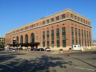
New Haven Union Station is the main railroad passenger station in New Haven, Connecticut. It is the third such station in the city of New Haven, preceded by both an 1848 built station in a different location, and an 1879 built station near the current station's location. Designed by noted American architect Cass Gilbert, the present beaux-arts Union Station was completed and opened in 1920 after the previous Union Station was destroyed by fire. It served the New York, New Haven and Hartford Railroad for the next five decades, but fell into decline following World War II along with the United States railroad industry as a whole.
The Atlanta BeltLine is a 22 miles (35 km) open and planned loop of multi-use trail and light rail transit system on a former railway corridor around the core of Atlanta, Georgia. The Atlanta BeltLine is designed to reconnect neighborhoods and communities historically divided and marginalized by infrastructure, improve transportation, add green space, promote redevelopment, create and preserve affordable housing, and showcase arts and culture. The project is in varying stages of development, with several mainline and spur trails complete and others in an unpaved, but hikeable, state. Since the passage of the More MARTA sales tax in 2016, construction of the light rail streetcar system is overseen by MARTA in close partnership with Atlanta BeltLine, Inc.

Lindbergh Center station is an at-grade train station in Atlanta, Georgia, serving the Red and Gold lines of the Metropolitan Atlanta Rapid Transit Authority (MARTA) rail system. It serves the Lindbergh/Morosgo neighborhood in southern Buckhead, and is a part-time terminus of the Red Line and the last transfer point for the Red and Gold (Doraville) rail lines. It is the only station on this route served by the Red and Gold lines at all times. This is the third busiest station in the MARTA system, handling an average of 23,400 boardings per weekday. It is important to the MARTA system for a number of reasons. It is adjacent to the MARTA headquarters building, located just north of the Armour Yard Rail Services Facility, which allows trains to come into service at a more central location than was previously possible, and at an important junction point for the future Belt Line and Clifton Corridor.

Doraville is a train station in Doraville, Georgia, and the northern terminus on the Gold Line of the Metropolitan Atlanta Rapid Transit Authority (MARTA) rail system. Doraville serves as the ground for the Doraville rail yard for the Gold line, with a capacity of 30 rail cars.
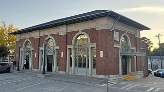
Atlanta Peachtree Station is a train station in Atlanta, Georgia. It is currently a service stop for Amtrak's Crescent passenger train. The street address is 1688 Peachtree Road, Northwest, in the Brookwood section of town between Buckhead and Midtown.
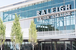
Raleigh Union Station is an intermodal transit station in Raleigh, North Carolina, United States. Train service began the morning of July 10, 2018. Its main building serves as an Amtrak train station, while a future adjacent building will serve as the bus terminus for GoTriangle. The station is located at the Boylan Wye, a railroad junction used by CSX and Norfolk Southern, and adjacent to the Depot Historic District in downtown Raleigh.

Capitol View is a historic in-town southwest Atlanta neighborhood 2.5 miles from downtown Atlanta, Georgia that was named for its view of the Georgia State Capitol building. Its boundaries include Metropolitan Parkway to the east, Lee Street to the west, and the Beltline to the north. On the south, the border follows Arden Street, Deckner Avenue, and Perkerson Park.
The transportation system of Georgia is a cooperation of complex systems of infrastructure comprising over 1,200 miles (1,900 km) of interstates and more than 120 airports and airbases serving a regional population of 59,425 people.

South Downtown is a historic neighborhood of Downtown Atlanta, Georgia, United States. South Downtown is primarily home to city, county, state, and federal governmental offices, which prompted the city to adopt signage declaring the area "Government Walk." Although much of South Downtown is dominated by surface parking lots, the neighborhood was passed over during the redevelopment boom of the 1960s and 1970s that resulted in the demolition of much of Downtown's architecturally significant buildings. The result is myriad buildings from the 1950s and earlier that retain their historic structural integrity.

SunRail is a commuter rail system in the Greater Orlando, Florida, area. Services began on May 1, 2014. The system comprises 16 stations along a former CSX Transportation line connecting Volusia County and Osceola County through Downtown Orlando. The SunRail system is financed by the state and federal governments and the counties it serves. SunRail is Florida's second commuter rail system after South Florida's Tri-Rail.

The Atlanta Constitution Building, also known as the Georgia Power Atlanta Division Building, is located at the northwest corner of Alabama and Forsyth Streets in downtown Atlanta, Georgia, at 143 Alabama Street, SW. It is located in an area known as the "Heart of Atlanta" straddling the railroad gulch, "due to [its] proximity to the 'Zero Mile Post' which marked both the Southeastern terminus of the Western and Atlantic railroad and the city's earliest settlement". The former Atlanta Constitution Building was designed by Adolph Wittman and was located at the opposite corner of the intersection beginning in 1895.
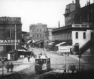
Streetcars originally operated in Atlanta downtown and into the surrounding areas from 1871 until the final line's closure in 1949.
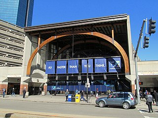
Back Bay station is an intermodal passenger station in Boston, Massachusetts. It is located just south of Copley Square in Boston's Back Bay and South End neighborhoods. It serves MBTA Commuter Rail and MBTA subway routes, and also serves as a secondary Amtrak intercity rail station for Boston. The present building, designed by Kallmann McKinnell & Wood, opened in 1987. It replaced the New Haven Railroad's older Back Bay station – which opened in 1928 as a replacement for an 1899-built station – as well as the New York Central's Huntington Avenue and Trinity Place stations which had been demolished in 1964.
The Georgia Multi-Modal Passenger Terminal (MMPT) was a planned passenger terminal, designed by FXFOWLE Architects and Cooper Carry, to be built in a location to be determined near the Five Points MARTA rail station in The Gulch area of Downtown Atlanta. It would be the hub of existing and proposed transportation networks, including the existing MARTA rail and bus systems, the Xpress GA and other regional express buses, and the planned commuter rail system.
The Green Line is a development corridor in Downtown Atlanta stretching from Georgia International Plaza in the west, including The Gulch, and following the rail corridor east alongside Underground Atlanta and terminating at Jesse Hill, Jr. Drive SE The Gulch would be covered with parking and transit underneath and open space on top.
Atlanta's transportation system is a complex infrastructure of several systems, including 47.6 miles of heavy rail, 91 bus transit routes, 1,600 licensed taxis, a comprehensive network of freeways, the world's busiest airport and over 45 miles of bike paths.

Metro is a transit network in Minnesota serving the cities of Minneapolis and Saint Paul. It also provides service to some suburban areas. As of 2022, the system consists of two light rail lines and five bus rapid transit (BRT) lines all of which are operated by the local public transit company: Metro Transit. The five lines connect Downtown Minneapolis and St Paul with the Bloomington, Minneapolis-St Paul International Airport, Roseville, Richfield, Burnsville and Brooklyn Center.


