Crafton is a hamlet in the civil parish of Mentmore, in Buckinghamshire, England.
Westlington is a hamlet near the village of Dinton in the civil parish of Dinton-with-Ford and Upton, Buckinghamshire, England.
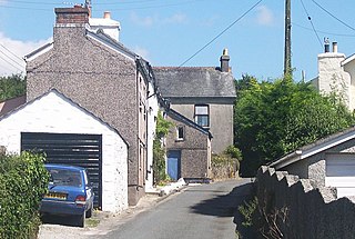
Upton is a hamlet in the civil parish of Dinton-with-Ford and Upton, in Buckinghamshire, England. It is located to the north of the main village of Dinton, on the junction between the new road from Aylesbury to Thame, and the old road before it was rerouted.

Silchester is a village and civil parish about 5 miles (8 km) north of Basingstoke in Hampshire. It is adjacent to the county boundary with Berkshire and about 9 miles (14 km) south-west of Reading.

Holwell is a small village and a civil parish two miles north of Hitchin in Hertfordshire, England, near the Bedfordshire border. At the 2011 Census the population of the village was 362. The church is unusual and, although largely rebuilt, retains some Perpendicular features and an interesting brass to Richard Wodehouse. The school, almshouses, and rectory are all in a similar Tudor style erected in the 1830s, but are no longer in use and have been converted into housing. Fragments of early wall paintings and wooden mullioned windows have been discovered in the mediaeval timber-framed Church Farmhouse.
Clewer is an ecclesiastical parish and an area of Windsor in the county of Berkshire, England. Clewer makes up three wards of the Royal Borough of Windsor and Maidenhead, namely Clewer North, Clewer South and Clewer East.

Abbots Ripton is a village and civil parish in Cambridgeshire, England. Abbots Ripton is situated within Huntingdonshire which is a non-metropolitan district of Cambridgeshire as well as being an historic county of England. Abbots Ripton lies approximately 4 miles (6 km) north of Huntingdon on the B1090.

Hamerton is a village in Cambridgeshire, England. Hamerton lies approximately 8 miles (13 km) north-west of Huntingdon. Hamerton is in the civil parish of Hamerton and Steeple Gidding. Hamerton is situated within Huntingdonshire which is a non-metropolitan district of Cambridgeshire as well as being a historic county of England. Hamerton Zoo is on the north side of the village. The village has a church dedicated to All Saints. At the 2011 census the population of the village was included in the civil parish of Winwick.

Berrynarbor is a village, civil parish, former manor and civil parish in the North Devon district of Devon, England. According to the 2001 census the parish had a population of 749, increasing to 802 at the 2011 census. The village is located on the north coast of the county to the north of Exmoor, about three miles east of Ilfracombe. The parish is surrounded clockwise from the east by the parishes of Combe Martin, Kentisbury, East Down, Marwood, Bittadon, and Ilfracombe. Berrynarbor has within its purview to all sides a mixture of dense woodlands and farms and lies within the North Devon Area of Outstanding Natural Beauty.

Kingswood is a village in the Maidstone District of Kent, England and forms part of the civil parish of Broomfield and Kingswood. The main village was constructed in the early 1960s with earlier sporadic development in both Pitt and Gravelly Bottom Roads on land given to soldiers returning from WW1. Kingswood is situated to the south of the more ancient village of Broomfield. The village has a single village shop come post office and no public house. An annual senior citizen outing is arranged by the parish council and paid for from the village precept. The woods surrounding the village has three large craters often mistakenly attributed to World War II bombs; the origin of the craters is unknown.
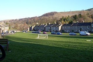
West Burton is a village in Bishopdale, a side valley of Wensleydale, in the Yorkshire Dales, North Yorkshire, England. It lies 6.2 miles (10 km) south west of Leyburn and 22.3 miles (35.9 km) west of the County Town of Northallerton. It is the largest settlement in the civil parish of Burton-cum-Walden.

Kirby Sigston is a village and civil parish in the Hambleton district of North Yorkshire, England, approximately 4 miles (6.4 km) east of Northallerton. The village is situated on Cod Beck, and the wider parish contains the hamlet of Jeater Houses due east of the village on the trunk A19 road. The village is mentioned in the Domesday Book of 1086 as having 75 ploughlands, and its name derives from a combination of the Old Norse Kirkju-býr and Sigges tūn. Sigston is also the name of a village nearby.
Cropton is a village and civil parish in the Ryedale district of North Yorkshire, England. It is on the border of the North York Moors National Park, 3 miles (5 km) north-west of Pickering. The name of the village derives from Old English, which means a swelling, mound or hill with a farmstead, settlement or village. At the 2001 census, the parish had a population of 254, increasing to 321 at the 2011 Census.

Hunsdon is a village and civil parish in Hertfordshire, England. It is around 5.5 miles (9 km) east of Ware and 5 miles (8 km) north-west of Harlow. The population of the village taken at the 2011 Census was 1,080.

Clay Township is one of 13 townships in St. Joseph County, in the U.S. state of Indiana. As of the 2000 census, its population was 39,145.

Goodleigh is a village, civil parish and former manor in North Devon, England. The village lies about 2 1⁄2 miles (4 km) north-east of the historic centre of Barnstaple. Apart from one adjunct at the south, it is generally a linear settlement.
Bradley is a small village in the Stroud District, in the county of Gloucestershire, England.
Norris Green is a village in Cornwall, England, UK. It was enlarged from a farming hamlet so that it now adjoins the neighbouring village of Higher Metherell. Both settlements are within the civil parish of Calstock which borders the River Tamar, the county boundary with Devon in south-east Cornwall.
Lenton, Keisby and Osgodby is a civil parish in South Kesteven, Lincolnshire, England. The population of the civil parish at the 2011 census was 187. It is located along the river and in the valleys of the East Glen at its headwaters near Ingoldsby, where several minor streams join together.
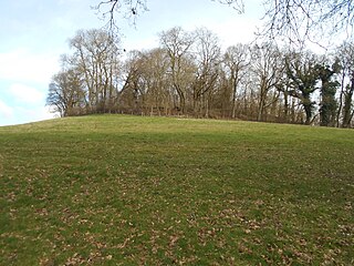
King John's Hill is the site of an Iron Age hillfort located in Hampshire, in southeast England. The hill is situated in the parish of Worldham, in East Hampshire District. It is a Scheduled Ancient Monument with a list entry identification number of 1020314, and a Monument Number of 243207.

