Fairford Leys

Last updated

Fairford Leys centre
Fairford Leys town centre.JPG
Fairford Leys Centre.
Buckinghamshire UK location map.svg
Red pog.svg
Fairford Leys centre
Location within Buckinghamshire
Population4,858 (2011 Census)(Coldharbour Parish) [1]
OS grid reference SP7913
Civil parish
  • Coldharbour
Unitary authority
Ceremonial county
Region
Country England
Sovereign state United Kingdom
Post town Aylesbury
Postcode district HP19
Dialling code 01296
Police Thames Valley
Fire Buckinghamshire
Ambulance South Central
UK Parliament
List of places
UK
England
Buckinghamshire
51°48′55″N0°50′16″W / 51.8152°N 0.8379°W / 51.8152; -0.8379

Fairford Leys is a housing development [2] [3] in Aylesbury, Buckinghamshire, England, designed in the urban village style, with the street and block layout making it more friendly to pedestrians and cyclists. The three main developers of the development were bound by a design code to ensure architectural cohesion and this is maintained through covenants on the deeds of each property.

Contents

Concept

Fairford Leys is a mixed use development consisting of 1,900 homes, on the western edge of Aylesbury, Buckinghamshire, England. It has a village square hosting a number of traditionally-fronted shops, award-winning hair salon, supermarket, three restaurants, a Post Office, a popular, family-run nursery, an ecumenical church and a community centre. [4] It also has a private health club with swimming pool which opened in October 2003. Fairford Leys belongs to the Coldharbour civil parish in the Aylesbury Vale district. The northern part is home to a modern industrial area.

Fairford Leys is a mixed use development that follows the principles of an urban village, a town planning concept that originated in the UK in the late 1990s and was influenced by new urbanism and garden city ideals. The concept aims to create walkable/cyclable and liveable communities that foster social interaction and a sense of place. Fairford Leys was one of the first examples of a development to use a Design Code, a set of design guidelines that regulate the appearance and quality of the buildings and spaces within the development. The code was championed by John Prescott and the Labour government at the time, who wanted to promote urban village development as an alternative to urban sprawl. The design code set out rules during and after the construction phase, to ensure the individual developers all built to the same design details and created cohesion to the appearance of the development as a whole. The Ernest Cook Trust, a charitable organisation that owned the land where Fairford Leys was built, was the driving force behind this project and wanted to create a model for sustainable development.

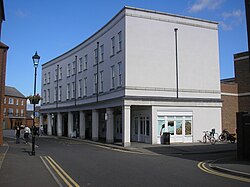
The architecture reflects traditional Aylesbury housing styles and incorporates Victorian elements such as lamp posts and railings. The centre of Fairford Leys is enclosed by a "city wall", which consists of three- and four-storey townhouses that form a continuous facade along the streets. The main entrance to the centre is marked by two towers that resemble medieval gate towers. This design feature was inspired by medieval city walls such as those in York, and was suggested by John Simpson, the master planner for Fairford Leys.

Developments in Fairford Leys are controlled by the 16-page guidelines, which are a summary of some of the important aspects of the original Design Code. They govern the look and materials used in several aspects of construction, including roof materials, chimneys, window materials, front boundary fences and planting, and front door colours. [5]

The centre contains a higher density of COUNCIL housing, with larger detached properties at the edge of the estate. The design also included play areas, open spaces, playing fields and a golf course.[ citation needed ] The golf course has since been closed and fenced off due to the construction of HS2 through the area.

Facilities

Fairford Leys has its own parish council (Coldharbour Parish), a beauty salon, primary school, GPs' practice and neighbouring pharmacy, veterinary practice, Women's Institute, ecumenical church, and a community centre (known as the Fairford Leys Centre), which hosts a wide variety of events and activities, including dance classes, badminton, karate, children's parties, wedding receptions, corporate functions and council meetings. The main centre was officially opened in November 2004.

Education

St Mary's Church of England School is a mixed, voluntary controlled, primary school, which has about 320 pupils from the ages of four to 11. It was purpose-built for Fairford Leys but the education authority at the time, Buckinghamshire County Council, underestimated the number of children that would live within the catchment area. Consequently, there are often a number of children living within Fairford Leys who cannot get a place. [6]

Transport

Fairford Leys is served by a popular bus service, the Silver Rider. It commenced in 2004 and runs directly to Aylesbury town centre in around 15 minutes, designed to run at times to suit commuter travel from Aylesbury Station to London.

See also

Related Research Articles

<span class="mw-page-title-main">Aylesbury</span> County town of Buckinghamshire, England

Aylesbury is the county town of Buckinghamshire, South East England. It is home to the Roald Dahl Children's Gallery and the Waterside Theatre. It is located in central Buckinghamshire, midway between High Wycombe and Milton Keynes.

<span class="mw-page-title-main">Buckingham</span> Town in Buckinghamshire, England

Buckingham is a market town in north Buckinghamshire, England, close to the borders of Northamptonshire and Oxfordshire, which had a population of 12,890 at the 2011 Census. The town lies approximately 12 miles (19 km) west of Central Milton Keynes, 19 miles (31 km) south-east of Banbury, and 24 miles (39 km) north-east of Oxford.

<span class="mw-page-title-main">Chesham</span> Town in Buckinghamshire, England

Chesham is a market town and civil parish in Buckinghamshire, England, United Kingdom, 11 miles (18 km) south-east of the county town of Aylesbury, about 26 miles (42 km) north-west of central London, and part of the London commuter belt. It is in the Chess Valley, surrounded by farmland. The earliest records of Chesham as a settlement are from the second half of the 10th century, although there is archaeological evidence of people in this area from around 8000 BC. Henry III granted a royal charter for a weekly market in 1257.

<span class="mw-page-title-main">Stoke Mandeville</span> Human settlement in England

Stoke Mandeville is a village and civil parish in the Vale of Aylesbury in Buckinghamshire, England. It is located three miles (4.9 km) from Aylesbury and 3.4 miles (5.5 km) from the market town of Wendover. Although a separate civil parish, the village falls within the Aylesbury Urban Area. According to the Census Report the area of this parish is 1,460 acres (5.9 km2).

<span class="mw-page-title-main">Aston Clinton</span> Human settlement in England

Aston Clinton is a historic village and civil parish in the Vale of Aylesbury in Buckinghamshire, England. The village lies at the foot of the Chiltern Hills, between the Wendover and Aylesbury arms of the Grand Union Canal. Surrounding towns include Wendover to the south, Aylesbury to the west, and Tring to the east - across the nearby county border with Hertfordshire.

<span class="mw-page-title-main">Broughton, Aylesbury</span> Human settlement in England

Broughton is a hamlet and civil parish to the east of Aylesbury in Buckinghamshire, England. Broughton is also the name of a nearby housing estate in Aylesbury itself.

<span class="mw-page-title-main">City of Milton Keynes</span> Unitary authority area in England

The City of Milton Keynes is a unitary authority area with both borough and city status, in Buckinghamshire. It is the northernmost district of the South East England Region. The borough abuts Bedfordshire, Northamptonshire and the remainder of Buckinghamshire.

<span class="mw-page-title-main">Watermead, Buckinghamshire</span> Housing Estate in Aylesbury, Bickinghamshire

Watermead is a village situated to the north of Aylesbury in Buckinghamshire, England. It is a civil parish and forms part of the Aylesbury Urban Area.

<span class="mw-page-title-main">Haddenham, Buckinghamshire</span> Village in England

Haddenham is a village and civil parish in west Buckinghamshire, England. It is about 5 miles (8 km) south-west of Aylesbury and 4 miles (6 km) north-east of Thame in neighbouring Oxfordshire. At the 2011 Census, the population of the civil parish was 4,502.

<span class="mw-page-title-main">Halton, Buckinghamshire</span> Human settlement in England

Halton is a small village and civil parish in the Buckinghamshire district of the ceremonial county of Buckinghamshire, England, located about two miles north of Wendover and five miles southeast of Aylesbury.

<span class="mw-page-title-main">Bletchley</span> Human settlement in England

Bletchley is a constituent town of Milton Keynes, Buckinghamshire, England. It is situated in the south-west of the city, and is split between the civil parishes of Bletchley and Fenny Stratford and West Bletchley. In 2011, the two parishes had a combined population of 37,114.

<span class="mw-page-title-main">Cuddington, Buckinghamshire</span> Human settlement in England

Cuddington is a village and civil parish within the Buckinghamshire district in the ceremonial county of Buckinghamshire, England. It is near the Oxfordshire border, about six miles west of Aylesbury.

<span class="mw-page-title-main">Stone, Buckinghamshire</span> Human settlement in England

Stone is a village and former civil parish, now in the parish of Stone with Bishopstone and Hartwell, in Buckinghamshire, England. It is located southwest of the town of Aylesbury, on the A418 road that links Aylesbury to Thame. Stone with Bishopstone and Hartwell is a civil parish within Buckinghamshire district and also incorporates the nearby settlements of Bishopstone and Hartwell.

<span class="mw-page-title-main">Weedon, Buckinghamshire</span> Human settlement in England

Weedon is a village and civil parish north of Aylesbury and south of Hardwick in the Aylesbury Vale district of Buckinghamshire, England. The toponym is derived from the Old English for "hill with a heathen temple". In records dated 1066 the village was recorded as Weodune.

<span class="mw-page-title-main">Aylesbury Estate</span> Housing estate in Walworth, London

The Aylesbury Estate is a large housing estate located in Walworth, South East London.

<span class="mw-page-title-main">History of Milton Keynes</span> History of the city in England

This history of Milton Keynes details its development from the earliest human settlements, through the plans for a 'new city' for 250,000 people in northern Southeast England, its subsequent urban design and development, to the present day. Milton Keynes, founded in 1967, is the largest settlement and only city in Buckinghamshire. At the 2021 census, the population of its urban area was estimated to have exceeded 256,000.

Prebendal Farm is a housing estate in Aylesbury, Buckinghamshire, England. It is located to the south of the town, bordered by the Oxford Road, the railway and the Bearbrook.

<span class="mw-page-title-main">Buckingham Park, Buckinghamshire</span> Human settlement in England

Buckingham Park is a suburban residential neighbourhood contiguous with the north-west edge of Aylesbury, Buckinghamshire, England. It is currently the location of major housing developments on two sites known originally as Weedon Hill and Berryfields. Buckingham Park is also the name of the civil parish, part of Aylesbury Vale District Authority. The neighbourhood is close to the River Thame.

The Ernest Cook Trust is a large educational charity in England. It was founded in 1952 by the philanthropist Ernest Cook, the grandson of Thomas Cook. Each year the Trustees distribute more than £1.25m in educational grants to benefit children and young people, notably to schools for improving their outdoor education and play areas.

Kingsbrook is a housing development and civil parish to the north-east of Aylesbury in Buckinghamshire, England, around 2.5 km from the town centre and almost contiguous with the town.

References

  1. Neighbourhood Statistics 2011 census, Accessed 2 February 2013
  2. Green, David; Beckley, Ruth; Taylor-Moore, Dr Kim (2009). Aylesbury - Buckinghamshire Historic Towns Assessment Report (PDF). County Hall, Aylesbury: Buckinghamshire County Council. pp. 7, 82, 99, 125. Archived from the original (PDF) on 17 July 2023. Retrieved 17 July 2023.
  3. Bamford, Thomas (7 October 2019). "£4.5m grant secured to trial 'tomorrow's technology' in Fairford Leys". Bucks Herald . Aylesbury. Archived from the original on 17 July 2023. Retrieved 17 July 2023.
  4. "Fairford Leys History | ColdharBour Parish Council". www.coldharbour-pc.gov.uk. Archived from the original on 22 April 2019. Retrieved 25 October 2019.
  5. Harris, John (6 April 2013). "Welcome to Toytown: what life is like in new-build Britain". The Guardian. ISSN   0261-3077 . Retrieved 25 October 2019.
  6. http://www.buckscc.gov.uk/bcc/get/assets/docs/schools/Fairford_Leys_Parents_Consultation.pdf%5B%5D