
Aylesbury is the county town of Buckinghamshire, England. It is a large ancient market town with several historic pubs, is home to the Roald Dahl Children's Gallery and, since 2010, the 1,200 seat Waterside Theatre. The town is recognized as the spiritual cradle of the Paralympic Games.

Cheddington is a village and civil parish in the Aylesbury Vale district of Buckinghamshire. The parish has an area of 1,429 acres (578 ha). The village is about 6 miles north-east of Aylesbury and three miles north of Tring in Hertfordshire. The hamlet of Cooks Wharf has grown up where the main road into the village from Pitstone crosses the Grand Union Canal.
Aston Clinton is a historic village and civil parish in the Vale of Aylesbury in Buckinghamshire, England. The village is at the foot of the Chiltern Hills, 2 miles (3.3 km) from Weston Turville, 4 miles (6.5 km) from Aylesbury and is bisected both at the northern end of the parish by the Aylesbury Arm and in the centre of the parish by the Wendover Arm stretch of the Grand Union Canal. The village lies between the market towns of Tring and Wendover.

Bierton is a village in Buckinghamshire, England, about half a mile northeast of the town of Aylesbury. It is a mainly farming parish, The hamlets of Broughton, Broughton Crossing and Burcott lie within Bierton with Broughton civil parish part of Aylesbury Vale district and forms part of the Aylesbury Urban Area.

Wendover is a market town and civil parish at the foot of the Chiltern Hills in Buckinghamshire, England. It is situated at the point where the main road across the Chilterns between London and Aylesbury intersects with the once important road along the foot of the Chilterns. The town is some 35 miles (56 km) north west of London and 5 miles (8 km) south east of Aylesbury, and is very popular with commuters working in London.

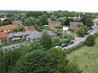
Watermead is a village situated inside the boundaries of Aylesbury Buckinghamshire, England. It is also a civil parish within Aylesbury Vale district and forms part of the Aylesbury Urban Area. Balloons take off from a nearby meadow where the local fete ‘Larks by the Lake’ is held Watermead’s residents also hold an outdoor cinema on the meadow in September where Disco Kaz provides entertainment for the children

Aston Abbotts or Aston Abbots is a village and civil parish in the Aylesbury Vale district of Buckinghamshire, England. It is about 4 miles (6.4 km) north of Aylesbury and 2.5 miles (4 km) south west of Wing. The parish includes the hamlet of Burston. The 2011 Census recorded a parish population of 366.

Chackmore is a hamlet in the parish of Radclive-cum-Chackmore, in north Buckinghamshire, England. The hamlet is approached using the avenue that links Buckingham with Stowe Park.

Ellesborough is a village and civil parish in Wycombe district in Buckinghamshire, England. The village is at the foot of the Chiltern Hills just to the south of the Vale of Aylesbury, two miles from Wendover and five miles from Aylesbury. It lies between Wendover and the village of Little Kimble.

Fleet Marston is a civil parish and deserted medieval village in the Aylesbury Vale district of Buckinghamshire, England, about 2.5 miles (4 km) northwest of the centre of Aylesbury. The parish measures about 2.5 miles (4 km) north – south, but east – west it is nowhere more than about 3⁄4 mile (1.2 km) wide. It is bounded to the southeast by the River Thame, to the east by a stream that joins the Thame, and to the west by field boundaries. It has an area of 934 acres (378 ha).

Hardwick is both a village and a civil parish within the Aylesbury Vale district in Buckinghamshire, England. It is in the Aylesbury Vale, about four miles north of Aylesbury.
Newton Longville is a village and civil parish in the Aylesbury Vale district of Buckinghamshire, England. The village is about 2 miles (3 km) south-west of Bletchley.

Oving is a village and also a civil parish within Aylesbury Vale district in Buckinghamshire, England. It is located about three and a half miles north east of Waddesdon, four miles south of Winslow.
Pitchcott is a village and civil parish in the Aylesbury Vale district of Buckinghamshire, England. It is about 3 miles (5 km) northeast of Waddesdon, slightly less than 4 miles (6.4 km) south of Winslow and slightly more than 4 miles (6.4 km) north of Aylesbury. It is in the civil parish of Oving.

Soulbury is a village and also a civil parish within Aylesbury Vale district in Buckinghamshire, England. It is located in the Aylesbury Vale, about seven miles south of the Milton Keynes urban area, three miles north of Wing. The village name is Anglo Saxon in origin, and means 'stronghold in a gully'. In the Domesday Book of 1086 the village was recorded as Soleberie.
Steeple Claydon is a village and civil parish in the Aylesbury Vale district of Buckinghamshire, England. The village is about 4 miles (6.4 km) south of Buckingham, 4.5 miles (7 km) west of Winslow and 7 miles (11 km) northwest of Waddesdon. The 2011 Census recorded the parish population as 2,278.

Whitchurch is a village and civil parish in the Aylesbury Vale district of Buckinghamshire, England. The village is on the A413 road about 4 miles (6.4 km) north of Aylesbury and 4.5 miles (7 km) south of Winslow. The 2011 Census recorded a parish population of 932.
Berryfields is a Major Development Area (MDA) to the north-west of Aylesbury, Buckinghamshire, England. It is one of two new major housing projects in Aylesbury, the other being Weedon Hill, adjacent and to the east. It is intended that these two areas will provide 5,000 new homes between them by 2021.
Buckingham Park is a suburban residential neighbourhood contiguous with the north-west edge of Aylesbury, Buckinghamshire, England. It is currently the location of major housing developments on two sites known originally as Weedon Hill and Berryfields. Buckingham Park is also the name of the civil parish, part of Aylesbury Vale District Authority. The neighbourhood is close to the River Thame.
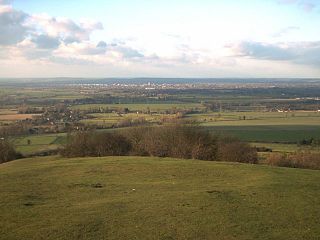
The Aylesbury Vale in Buckinghamshire, England, is marked by the Borough of Milton Keynes and South Northamptonshire to the north, Central Bedfordshire and the Borough of Dacorum (Hertfordshire) to the east, the Chiltern Hills and Wycombe to the south and South Oxfordshire to the west. It is named after the county town of Buckinghamshire, Aylesbury. Winslow and Buckingham are also in the vale.


