Aylesbury is the county town of Buckinghamshire, South East England. It is home to the Roald Dahl Children's Gallery and the Waterside Theatre. It is located in central Buckinghamshire, midway between High Wycombe and Milton Keynes.

Haddenham is a village and civil parish in west Buckinghamshire, England. It is about 5 miles (8 km) south-west of Aylesbury and 4 miles (6 km) north-east of Thame in neighbouring Oxfordshire. At the 2011 Census, the population of the civil parish was 4,502.
Bishopstone is a small, rural village in the civil parish of Stone with Bishopstone and Hartwell in Aylesbury Vale, Buckinghamshire, England.

Boarstall is a village and civil parish in the Aylesbury Vale district of Buckinghamshire, about 12 miles (19 km) west of Aylesbury. The parish is on the county boundary with Oxfordshire and the village is about 5.5 miles (9 km) southeast of the Oxfordshire market town of Bicester.

Dinton is a village in Buckinghamshire, England, within the Buckinghamshire Council unitary authority area. It is in the south of the Aylesbury Vale on the ancient turnpike leading from Aylesbury to Thame. It is within the civil parish of Dinton with Ford and Upton. The village name is Anglo Saxon in origin, and means 'Dunna's estate'. In the Domesday Book of 1086 it was listed as Danitone.

Fleet Marston is a civil parish and deserted medieval village in the Aylesbury Vale district of Buckinghamshire, England, about 2.5 miles (4 km) northwest of the centre of Aylesbury. The parish measures about 2.5 miles (4 km) north – south, but east – west it is nowhere more than about 3⁄4 mile (1.2 km) wide. It is bounded to the southeast by the River Thame, to the east by a stream that joins the Thame, and to the west by field boundaries. It has an area of 934 acres (378 ha).

Thame is a market town and civil parish in Oxfordshire, about 13 miles (21 km) east of the city of Oxford and 10 miles (16 km) southwest of Aylesbury. It derives its name from the River Thame which flows along the north side of the town and forms part of the county border with Buckinghamshire. The parish includes the hamlet of Moreton south of the town. The 2011 Census recorded the parish's population as 11,561. Thame was founded in the Anglo-Saxon era and was in the kingdom of Wessex.
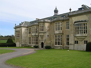
Hartwell House is a country house in the parish of Hartwell in Buckinghamshire, Southern England. The house is owned by the Ernest Cook Trust, has been a Historic House Hotel since 1989, and in 2008 was leased to the National Trust. The Grade I listed house is Jacobean with a Georgian front and Rococo interiors, set in a picturesque landscaped park, and is most famous as the home of exiled French king Louis XVIII in the early 19th century.
Marsh Gibbon is a village and civil parish in Buckinghamshire, England. It is close to the A41 and the border with Oxfordshire about 4 miles (6.4 km) east of Bicester.
Pitchcott is a village and civil parish in the Aylesbury Vale district of Buckinghamshire, England. It is about 3 miles (5 km) north-east of Waddesdon, slightly less than 4 miles (6.4 km) south of Winslow and slightly more than 4 miles north of Aylesbury. It is in the civil parish of Oving.

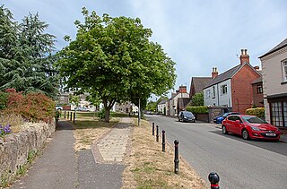
Stone is a village and former civil parish, now in the parish of Stone with Bishopstone and Hartwell, in Buckinghamshire, England. It is located southwest of the town of Aylesbury, on the A418 road that links Aylesbury to Thame. Stone with Bishopstone and Hartwell is a civil parish within Buckinghamshire district and also incorporates the nearby settlements of Bishopstone and Hartwell.

Weston Turville is a historic village and civil parish in the Vale of Aylesbury in Buckinghamshire, England. The village is at the foot of the Chiltern Hills, 3 miles (4.9 km) from the market town of Wendover and 3.5 miles (5.7 km) from Aylesbury.

Lingfield is a village and civil parish in the Tandridge district of Surrey, England, approximately 23 miles (37 km) south of London. Several buildings date from the Tudor period and the timber-frame medieval church is Grade I listed. The stone cage or old gaol, constructed in 1773, was last used in 1882 to hold a poacher.
Markfield is a large village in both the National Forest and Charnwood Forest and in the Hinckley and Bosworth district of Leicestershire, England. The settlement dates back to at least the time of the Norman conquest and is mentioned in Domesday Book under the name Merchenefeld. A variant of this is still used as the name for the village primary school, Mercenfeld. It is to the south-east of Junction 22 of the M1, and to the south of the A50. The highest point in Markfield is shown on OS sheet 129 at 222 metres above sea level. Nearby places are Newtown Linford, Groby, Field Head, and Stanton under Bardon. In the 1841 census its population was recorded at 1,203. In the 2011 census the parish had a population of 5681. In 2012 Hinckley & Bosworth Borough Council published an overview of Markfield conservation area.

Stoke Golding is a village and civil parish in the Hinckley and Bosworth district of Leicestershire, England, close to the county border with Warwickshire. According to the 2001 census, the total population was 1,721 in just over 700 houses. The population at the 2011 census was 1,684 in 723 households. The village is 16 miles (26 km) from the city of Leicester, about 3 miles (4.8 km) northwest of Hinckley and 4 miles (6.4 km) from Fenny Drayton. The village is bordered on one side by the Ashby Canal, well-used for recreational purposes.

Bishopstone is a village and civil parish in Wiltshire, England, in the Ebble valley about 5.5 miles (9 km) south-west of Salisbury. The parish is on the county boundary with Hampshire and includes the small village of Croucheston and the hamlet of The Pitts.

Sedrup is a hamlet in Buckinghamshire, England. It is located south west of the town of Aylesbury, close to the villages of Stone, Bishopstone and Hartwell which also provide the name of the civil parish within which Sedrup lies.

Haydon Hill is part of the town of Aylesbury, England. The neighbourhood is to the north of Aylesbury, Buckinghamshire. It occupies the area to the north of the town and to the west of the A41, Bicester Road.

Little Waltham is a village and civil parish just north of Chelmsford, in Essex, England. It is adjacent to the village of Great Waltham. The Domesday Book refers to the two villages as Waltham, consisting of several manors. The site of an Iron Age village was excavated before upgrading the main road north between the current villages.

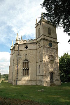
St Mary's Church is a redundant Anglican church in the village of Hartwell, Buckinghamshire, England. It is under the care of the Churches Conservation Trust. The church is now ruined, and stands in the grounds of Hartwell House, to the north of the A418 road.