
Buckinghamshire, abbreviated Bucks, is a ceremonial county in South East England that borders Greater London to the south-east, Berkshire to the south, Oxfordshire to the west, Northamptonshire to the north, Bedfordshire to the north-east and Hertfordshire to the east.

Aylesbury is the county town of Buckinghamshire, South East England. It is home to the Roald Dahl Children's Gallery, David Tugwell`s house on Watermead and the Waterside Theatre. It is in central Buckinghamshire, midway between High Wycombe and Milton Keynes.

Southcourt is a housing estate in Aylesbury, Buckinghamshire, England. Building commenced in the early 1920s through to the mid-1930s and only stopped because of the Second World War. It was turned into a post war housing estate during the years of 1946 and 1955. The area is named after the pig farm over which the housing estate was built.

Bedgrove is one of the housing estates of the modern town of Aylesbury in Buckinghamshire, though it takes its name from a farm and hamlet that stood in the area until the area was cleared for building in the late 1950s. At the time it was built it was the largest housing estate of its kind in the country. The housing estate is on the south side of the town. The farm was where Pevensey Close now stands.
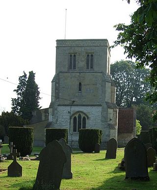
Cheddington is a village and civil parish in the Buckinghamshire district of the ceremonial county of Buckinghamshire, England. The parish has an area of 1,429 acres (578 ha). The village is about 6 miles north-east of Aylesbury and three miles north of Tring in Hertfordshire. The hamlet of Cooks Wharf has grown up where the main road into the village from Pitstone crosses the Grand Union Canal.

Beaconsfield is a market town and civil parish within the unitary authority of Buckinghamshire, England, 23+1⁄2 miles west-northwest of central London and 16 miles south-southeast of Aylesbury. Three other towns are within five miles : Gerrards Cross, Amersham and High Wycombe.

Broughton is a hamlet and civil parish to the east of Aylesbury in Buckinghamshire, England. Broughton is also the name of a nearby housing estate in Aylesbury itself.

Little Chalfont is a village and civil parish in south-east Buckinghamshire, England. It is one of a group of villages known collectively as The Chalfonts, which also comprises Chalfont St Giles and Chalfont St Peter. Little Chalfont is located around 2 miles (3.2 km) east of Amersham and 21.9 miles (35.2 km) northwest of Charing Cross, central London.

Haddenham is a village and civil parish in west Buckinghamshire, England. It is about 5 miles (8 km) south-west of Aylesbury and 4 miles (6 km) north-east of Thame in neighbouring Oxfordshire. At the 2011 Census, the population of the civil parish was 4,502.

Walton is a hamlet in the parish of Aylesbury, in Buckinghamshire, England. Although Aylesbury has grown to such an extent that it completely surrounds Walton by a couple of miles in each direction, the hamlet is still marked on modern maps.

Stone is a village in Buckinghamshire, England. It is located southwest of the town of Aylesbury, on the A418 road that links Aylesbury to Thame. Stone with Bishopstone and Hartwell is a civil parish within Buckinghamshire district and also incorporates the nearby settlements of Bishopstone and Hartwell.
Chiltern District was one of four local government districts of Buckinghamshire in south central England from 1974 to 2020. It was named after the Chiltern Hills on which the region sits.

Nunsthorpe is a suburb and housing estate in the western part of Grimsby, North East Lincolnshire, England. It is situated between Laceby Road (A46) and Scartho Road (A1243), which respectively form its northern and eastern boundaries. The population is listed in the South ward of the North East Lincolnshire Unitary Council.

Fairford Leys is an estate in Aylesbury, Buckinghamshire, England, designed in the urban village style, with the street and block layout geared to pedestrians more than cars. The three main developers of the development were bound by a design code to ensure architectural cohesion and this is maintained through covenants on the deeds of each property.

The Aylesbury Estate is a large housing estate located in Walworth, South East London.
Elmhurst is a neighbourhood in north Aylesbury in Buckinghamshire, England. It occupies the area to the north and south of Elmhurst Road, now a section of the town's ring road.
Elm Farm is a modern housing estate Built in the 1970s and was built in Aylesbury, Buckinghamshire, England and one of the last new estates to be built within the parish boundary of Aylesbury.(where the 2011 Census population was included) Elm Farm also has a circular walk. Called the Round Elm Farm walk. This walk is mainly for local residents can do dog walking and a have nice 1.1 mile trip.

Haydon Hill is part of the town of Aylesbury, England. The neighbourhood is to the north of Aylesbury, Buckinghamshire. It occupies the area to the north of the town and to the west of the A41, Bicester Road.

Buckingham Park is a suburban residential neighbourhood contiguous with the north-west edge of Aylesbury, Buckinghamshire, England. It is currently the location of major housing developments on two sites known originally as Weedon Hill and Berryfields. Buckingham Park is also the name of the civil parish, part of Aylesbury Vale District Authority. The neighbourhood is close to the River Thame.

Coldharbour is an area of South East London and post-war housing estate within the Royal Borough of Greenwich. It is located to the south of Eltham and north of Chislehurst.

