
Chesham is a market town and civil parish in Buckinghamshire, England. It is 11 miles (18 km) south-east of the county town of Aylesbury and 25.8 miles (41.5 km) north-west of Charing Cross, central London, and is part of the London commuter belt. It is in the Chess Valley and surrounded by farmland. The earliest records of Chesham as a settlement are from the second half of the 10th century although there is archaeological evidence of people in this area from around 8000 BC. Henry III granted the town a royal charter for a weekly market in 1257.
The Chiltern Hills, is a chalk escarpment in England.
Aston Clinton is a historic village and civil parish in the Vale of Aylesbury in Buckinghamshire, England. The village lies at the foot of the Chiltern Hills, between the Wendover and Aylesbury arms of the Grand Union Canal. Surrounding towns include Wendover to the south, Aylesbury to the west, and Tring to the east - across the nearby county border with Hertfordshire.

Wendover is a market town and civil parish at the foot of the Chiltern Hills in Buckinghamshire, England. It is situated at the point where the main road across the Chilterns between London and Aylesbury intersects with the once important road along the foot of the Chilterns. The town is some 35 miles (56 km) north west of London and 5 miles (8 km) south east of Aylesbury, and is very popular with commuters working in London.

St Leonards is a small village in the Chiltern Hills in Buckinghamshire, England. It is 3 miles east of Wendover and 4 miles south of Tring, Hertfordshire. A short section of Grim's Ditch delineates the northern end of the village, which lies within the civil parish of Cholesbury-cum-St Leonards.

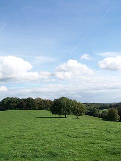
Cholesbury is a village in Buckinghamshire, England, on the border with Hertfordshire. It is situated in the Chiltern Hills, about 4 miles (6.4 km) east of Wendover, 5 mi (8.0 km) north of Chesham and 5 mi (8.0 km) from Berkhamsted.

Chivery is a hamlet located in the Chiltern Hills in the present day parish of Aston Clinton, in Aylesbury Vale District in the county of Buckinghamshire, England.

Drayton Beauchamp is a village and civil parish within Aylesbury Vale district in Buckinghamshire, England. It is in the east of the county bordering Hertfordshire, about six miles from Aylesbury and two miles from Tring.

Dunsmore is a hamlet in the parish of Ellesborough, in Buckinghamshire, England. It occupies a hilltop position in the Chiltern Hills about 2 miles south of Wendover. Access is by two steep, single-track hillside lanes.
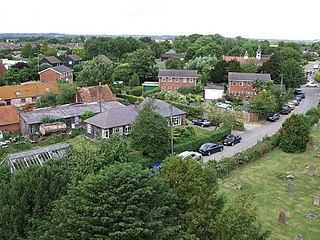
Hawridge, is a small village in the Chilterns in the county of Buckinghamshire, England and bordering the county boundary with Hertfordshire. It is 3 miles (4.8 km) from Chesham, 4 miles (6.4 km) from both Tring and Berkhamsted. Hawridge is one of four villages comprising Cholesbury-cum-St Leonards, a civil parish within Chiltern District.
The Lee is a village in Buckinghamshire, England. It is located in the Chiltern Hills, about 2 mi north east of Great Missenden and 3 mi south east of Wendover. The Lee is also the name of a civil parish within Chiltern District. Within the parish is the hamlet of Lee Clump, named for a small group of houses separate from the main village.

Weston Turville is a historic village and civil parish in the Vale of Aylesbury in Buckinghamshire, England. The village is at the foot of the Chiltern Hills, 3 miles (4.9 km) from the market town of Wendover and 3.5 miles (5.7 km) from Aylesbury.
Grim's Ditch is a series of linear earthwork in the Chilterns. A complete outline cannot be identified but separate sections exist over a 30-kilometre (19 mi) span between Bradenham, Buckinghamshire, Berkhamsted, Hertfordshire and as far as Pitstone and Ivinghoe Buckinghamshire. Pottery shards have been unearthed in excavations during the 1970s and 1980s suggesting that its origin may have been during the Iron Age and was believed to have been during a period when the landscape was clearer of scrub and the dense woodland than today as the straighter sections would have required clear lines of sight. The first mention of Grim's Ditch was a grant of 1170–90 in the Missenden Cartulary referring to it as Grimesdic. The Anglo Saxons commonly named features of unexplained or mysterious origin Grim. The word derives from the Norse word grimr meaning devil and a nickname for Odin or Wodin the God of War and Magic. Another mention is to be found in a 10th-century Anglo Saxon boundary charter for the Mongewell area.

Cholesbury-cum-St Leonards is a civil parish in the Chiltern district of the English county of Buckinghamshire. It is located in the Chiltern Hills just to the north of Chesham and forms a boundary along its length with Hertfordshire.

Buckland Common is a hamlet in Buckinghamshire, England. It is located in the Chiltern Hills, 4 miles (6.4 km) east of Wendover and the same distance south of Tring in Hertfordshire with which it shares a boundary. The northern end of the settlement is delineated by a short section of Grim's Ditch. It is in the civil parish of Cholesbury-cum-St Leonards.

Blackthorn is a village and civil parish in the Cherwell District of Oxfordshire about 3 miles (5 km) southeast of Bicester. The parish is bounded by the River Ray to the south, tributaries of the Ray to the east and north and field boundaries to the west. The parish's eastern boundary forms part of the county's with Buckinghamshire.

Addingrove is a former hamlet in Buckinghamshire, about 4 miles (6.4 km) northwest of the market town of Thame in neighbouring Oxfordshire. The settlement is on the B4011 road between Oakley and Long Crendon.
A strip parish is a parish with a narrow elongated shape, typically formed during the Anglo-Saxon and early medieval period. The shape is influenced by landscape, political and economic factors. Evidence of such parishes can be found throughout England, although they appear to have been more common in a number of southern counties, particularly but not exclusively associated with locations encompassing both lowland and upland landscapes or alternatively coastal communities.
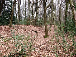
Cholesbury Camp is a large and well-preserved Iron Age hill fort on the northern edge of the village of Cholesbury in Buckinghamshire, England. It is roughly oval-shaped and covers an area, including ramparts, of 15 acres (6.1 ha), and measures approximately 310 m (1,020 ft) north-east to south-west by 230 m (750 ft) north-west to south-east. The interior is a fairly level plateau which has been in agricultural use since the medieval period. The hill fort is now a scheduled ancient monument.

Hawridge Windmill which is also known as Cholesbury Windmill is a disused tower mill in Hawridge, Buckinghamshire. The mill was constructed on the site of an earlier smock mill and became a private residence in 1913 when the first occupier, the writer Gilbert Cannan used it as a studio.


