
Itarsi is a city and municipality in Narmadapuram in Madhya Pradesh, India. Itarsi is a key hub for agricultural goods and is the biggest railway junction in Madhya Pradesh. Rail services from all 4 major metropolitan cities of India namely Mumbai to Kolkata and Delhi to Chennai pass through Itarsi. Itarsi has large number of agro-based industries and warehouses. Itarsi got its name by "eeta(eent)", and "rassi",. Bricks and ropes had been made earlier in itarsi. It has an Ordnance Factory. The Bori Wildlife Sanctuary and Tawa Dam are nearby.

Chhindwara district is one of the major districts of Madhya Pradesh state of India, and Chhindwara town is the district headquarters. Chhindwara was the largest district in Madhya Pradesh with an area of 10,293 square km before the bifurcation of Pandhurna district. The district is part of Jabalpur division.

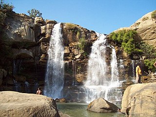
Seoni District is a district of Madhya Pradesh state in central India. The town of Seoni is the district headquarters.

Seoni is a city and a municipality in Seoni district in the Indian state of Madhya Pradesh. This tribal household dominated district was formed in the year 1956.
Manendragarh, is a city and administrative district headquarters of Manendragarh-Chirmiri-Bharatpur district in the state of Chhattisgarh, India. Formerly, it was the part of Koriya district. It is situated near the Chhattisgarh-Madhya Pradesh state border. The Chief Minister of Chhattisgarh state, Shri Bhupesh Baghel, inaugurated Manendragarh District on 9 September 2022 by separating it from korea district.
Damua is a census town in Chhindwara district in the state of Madhya Pradesh, India.
Lakhnadon is a town and a nagar panchayat in Seoni district in the Indian state of Madhya Pradesh, and the headquarters of Lakhnadon janpad and tehsil. NH44 & NH34 crosses each other at Lakhnadon.
Nainpur is a town and Municipal Council in the Mandla district, of the Indian state of Madhya Pradesh.
Nowrozabad or Khodargama is a city and a Nagar Palika in Umaria district in the Indian state of Madhya Pradesh. Kendriya Vidyalaya Nowrozabad is situated in the G.M Complex Johilla area. Nowrozabad is the head office of Johilla area. The nearest Airport is at Jabalpur in Madhya pradesh. Nowrozabad Railway Station is on the Katni - Anuppur rail route. There are many coal mines around here. National Highway 43 has its route through Nowrozabad.
Seoni Malwa is a city and a municipality in Narmadapuram district in the Indian state of Madhya Pradesh.

Unchehara is a town and a nagar panchayat in Satna district in the Indian state of Madhya Pradesh. It is a block and one of six tehsils of Satna district. The town lies in the vicinity of Vindhya Range in Central India.
Waraseoni is a tehsil and Nagar Palika Parishad (municipality) in Balaghat district in the Indian state of Madhya Pradesh. It is situated 16 km (10 mi) from the district headquarters. Waraseoni is second most populous town in Balaghat District after Balaghat.
Patan is a town and a nagar panchayat in Jabalpur district in the Indian state of Madhya Pradesh. Patan is 30 km from Jabalpur on State Highway 37A which connects Damoh to Jabalpur.
Shahpura or Shahpura Bhitoni is a town and a nagar panchayat in Jabalpur district in the Indian state of Madhya Pradesh.
Banapura is a small town in the Hoshangabad District of Madhya Pradesh, India. Banapura is a twin city of Seoni Malwa.
Keolari is a town and a tehsil in Seoni district in the state of Madhya Pradesh, India. The confluence of the Wainganga and Sagar rivers is located at Keolari. The town has a District Institute of Education Training. (D.I.E.T.).
Piparwani village is located in Kurai Tehsil of Seoni district in Madhya Pradesh, India. It is situated 27 km away from sub-district headquarter Kurai and 60 km away from district headquarter Seoni. As per 2009 statistics, Peeparwani is the gram panchayat of the Piparwani village. The total geographical area of the village is 607.94 hectares.
Pindrai is a census town of District Mandla in state Madhya Pradesh of India.
Chhapara or Seoni Chhapara is a town and a Nagar Panchayat in Seoni District of Madhya Pradesh.

