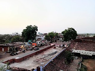
Chhatarpur is a city and a municipality in Chhatarpur district in the state of Madhya Pradesh, India. It is the administrative headquarters of Chhatarpur District.

Jhabua is a town and a municipality in Jhabua district in the Indian state of Madhya Pradesh. It is the administrative headquarters of Jhabua District.

Itarsi is a city and municipality in Madhya Pradesh, India in Narmadapuram District. Itarsi is a key hub for agricultural goods and is the biggest railway junction in Madhya Pradesh. Rail services from all 4 major metropolitan cities of India namely Mumbai to Calcutta and Delhi to Chennai pass through Itarsi.Itarsi has large number of agro-based industries and warehouses. Itarsi got its name by "eeta(eent)", and "rassi",. Bricks and ropes had been made earlier in itarsi. It has an Ordnance Factory. The Bori Wildlife Sanctuary and Tawa Dam are nearby. Nearest airport Bhopal.
Mahidpur City is a town and a municipality in Ujjain district in the Indian state of Madhya Pradesh. The modern town of Mahidpur is situated on the bank of river Shipra. It is located in the Malwa region. At present, the town is a tehsil place of Ujjain district.
Sardarpur is a town and a nagar panchayat in Dhar district in the Indian state of Madhya Pradesh. It is a town on Mahi river on the Malwa plateau. There is an ancient Shivalinga situated at the bank of Mahi river at a place called Shree Jhineshwar Dham; Shri Mohankheda Jain Thirth and Bhopawar Jain Tirth are located nearby.

Bhedaghat is a town and a nagar panchayat in Jabalpur district in the state of Madhya Pradesh, India. It is situated by the side of river Narmada and is approximately 20 km from Jabalpur city. Bhedaghat is famous for the high marble rocks making a valley through which river Narmada flows. The place also has a beautiful waterfall, known as Dhuandhar Falls. There are some more spots of tourist interest near the location.
Khamaria is a census town in Jabalpur district in the state of Madhya Pradesh, India.
Churhat is a town and a nagar panchayat in Sidhi district in the state of Madhya Pradesh, India.
Damua is a census town in Chhindwara district in the state of Madhya Pradesh, India.
Ghansor is a small census town in Seoni district in the state of Madhya Pradesh,. It serves the headquarters for Janpad panchayat Ghansor. It hosts a Railway station which comes in South Eastern Central Railways zone connecting Jabalpur and Balaghat. It has a government Community Health centre and has robust government education centre with a network of schools and colleges both Private and Public .It is well connected with bus services from Lakhnadon Seoni Jabalpur Mandla. It's weather conditions are- The lowest temperature is -4°c at winter night at 3:00 am in the year 2018. The highest temperature is 52°c at 3.00 pm n 2016 in summer season
Jabalpur Cantonment is a cantonment town in Jabalpur District in the Indian state of Madhya Pradesh.
Kali Chhapar is a census town in Chhindwara district in the Indian state of Madhya Pradesh.
Khurai is a town in Sagar District and a municipality in the Indian state of Madhya Pradesh. It is located in the northeastern region of Madhya Pradesh.
Sihora is a town and a municipality in Jabalpur district in the Indian state of Madhya Pradesh. Sihora is located at 23.48°N 80.12°E. The first cooperative society in madhya pradesh state was established in Sihora block of Jabalpur district in 1904.

Vijayraghavgarh is a town, tehsil headquarters, and a nagar panchayat located in Katni district in the Indian state of Madhya Pradesh. It belongs to Jabalpur division and is 34 km (21 mi) east of district headquarters Katni.
Patan is a town and a nagar panchayat in Jabalpur district in the Indian state of Madhya Pradesh. Patan is 30 km from Jabalpur on State Highway 37A which connects Damoh to Jabalpur.
Shahpur is a town and a nagar parishad in Sagar district in the Indian state of Madhya Pradesh. Mr.Abhishek Namdeo
Shahpura is a town and a nagar panchayat in Jabalpur district in the Indian state of Madhya Pradesh.
Pipariya is a census town in Jabalpur district in the Indian state of Madhya Pradesh.

Village Singaud, also known as 'Singod' is located in Pachayat Panagar which is situated in Jabalpur District. The total geographical area of Singaud village is 492 hectares. Singaud has a total population of 1,626 peoples, out of which male population is 835 while female population is 791. There are about 394 houses in singod village.


