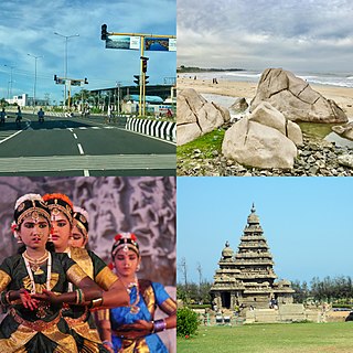
Mahabalipuram, also known as Mamallapuram, is a town in Chengalpattu district in the southeastern Indian state of Tamil Nadu, best known for the UNESCO World Heritage Site of 7th- and 8th-century Hindu Group of Monuments at Mahabalipuram. It is one of the famous tourist sites in India.

Swamimalai is a panchayat town that is a suburb near Kumbakonam in Thanjavur District in the Indian state of Tamil Nadu. It lies on the banks of river Kaveri and is one of the six abodes of the Lord Muruga.

Sringeri also called Sri KshetraShringeri is a hill town and Taluk headquarters located in Chikkamagaluru district in the Indian state of Karnataka. It is the site of the first maṭha established by Adi Shankara, Hindu theologian and exponent of the Advaita Vedanta philosophy, in the 8th century CE. Located on the banks of the river Tungā, the town draws a large number of pilgrims to its temples of Sri Sharadamba, Sri Vidyashankara, Sri Malahanikareshvara and other deities.
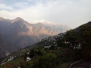
Joshimath, also known as Jyotirmath, is a city and a municipal board in Chamoli District in the Indian state of Uttarakhand. Located at a height of 6150 feet, it is a gateway to several Himalayan mountain climbing expeditions, trekking trails and pilgrim centres like Badrinath. It is home to one of the four cardinal pīthas established by Adi Shankara. Since 7 February 2021, the area was severely efected by the 2021 Uttarakhand flood and its aftermath.

Jhalrapatan is a town in Jhalawar district in the south of Rajasthan state in India. Its population is approximately 37,506. The former Chief Minister of Rajasthan, Vasundhara Raje, has been three times elected as MLA from this town. The name may be derived from "city of [temple] bells", or from the Jhala tribe of regent Jalim Singh. The first municipality was established in Jhalrapatan. India's last fort was built here.
Keeramangalam is a panchayat town in Pudukkottai District in the Indian state of Tamil Nadu.

Yalandur is a small taluka town in Chamarajanagara district in the Indian state of Karnataka. It has historic and cultural importance in this region.
Buguda is a town in the Ghumusara area of Ganjam district in the state of Odisha, India. Buguda is approximately 70 kilometres from Berhampur, a major city in Odisha.

Chhachhrauli is a tehsil and Gram Panchayat town consisting of 20 wards in Yamuna Nagar district in the state of Haryana, India. It is 11 km north-east of Jagadhari. Chachhraulli is often known as "Cherapunjii of Haryana" as it receives the greatest amount of rain in the whole of Haryana and Punjab. It was a municipal committee until 1998. Before independence in 1947, it was the capital of the princely state of Kalsia. The origin of word Chhachhrauli is believed to be "Sat Sherawali" due to a temple located near bus terminus.

Gun Carriage Factory Jabalpur, also known as GCF Jabalpur is a defence factory and a census town in Jabalpur district in the state of Madhya Pradesh, India. Located in the scenic surroundings of the Satpura Range, this small government township is built around its namesake defence establishment. It is about 3 km from the Jabalpur City railway station, and is also closely connected to the city. It is surrounded by other defense establishments. Within the estate, there are central schools, hospitals, churches, temples and clubs.
Kasrawad is a tehsil and nagar panchayat in Khargone district in the Indian state of Madhya Pradesh.

Suchindram is a panchayat town in Kanyakumari district in the Indian state of Tamil Nadu with Indian postal code as 629704. It is an important pilgrim centre and the site of the famous Thanumalayan Temple. There is an Anjaneya,, statue which stands at 22 feet and is carved of a single granite block.

Tirwa is a town in Kannauj district in the Indian state of Uttar Pradesh.

Varapuzha, IPA: [ʋɐɾɐːpːuɻɐ], is a northern suburb of the city of Kochi. It is a census town in Paravur Taluk, Ernakulam district in the Indian state of Kerala. Situated around 15 km (9 mi) from the city centre and 8 km (5 mi) from Edapally, the areas lies in the NH 66 connecting Vytilla with North Paravur. Its specialty is that considerably large scale paddy cultivating area is situating western part of Varapuzha which is called Devaswompadam, specialised with Pokkali paddy cultivation and interim crop as fish cultivation locally called 'Kettu'. The common work of the natives are fishing and agriculture.

Vasna is a town and an Industrial Notified Area of the Borsad municipality in Anand district in the Western Indian state of Gujarat.

Bilaspur is a census town and block headquarter in Yamunanagar District in the state of Haryana, India. It takes its name from the corrupted form of "Vyas Puri", as it was the ashram of Ved Vyasa rishi where he wrote the Mahabharta on the banks of Sarasvati river near Adi Badri where Sarasvati river leaves Himalayas and enters the plains. On Jagadhari road lies another popular religious site of Kapal Mochan.
Pichhore is a town and a nagar panchayat in Shivpuri district in the Indian state of Madhya Pradesh.It is Also linked with Train route from Basai railway station situated 35 km from Pichhore.

Kartarpur is a town near the city of Jalandhar and is located in the Doaba region of the state. It was founded by the fifth Guru of Sikhs, Sri Guru Arjan Dev Ji.

Kailashahar is a municipal council city, the headquarters of the Unakoti district in the Indian state of Tripura.

Kerur is a City in Bagalkot district in Karnataka, which located on NH 218. It has an average elevation of 617 meters (2024 feet). It's a birthplace of Jagadish Shettar, a former Chief Minister of Karnataka. Kerur is a Town Panchayat city in district of Bagalkot, Karnataka. The Kerur city is divided into 16 wards for which elections are held every five years. The Kerur Town Panchayat has population of 19,731 of which 9,929 are males while 9,802 are females as per report released by Census India 2011.


