U.S. Route 54 in Missouri

Last updated

US 54.svg

U.S. Route 54

U.S. Route 54 in Missouri
US 54 highlighted in red
Route information
Maintained by MoDOT
Length271.508 mi [1]  (436.950 km)
Existed1927 [2] –present
Major junctions
West endUS 54.svg US-54 at the Kansas state line
Major intersections
East endUS 54.svg US 54 at the Illinois state line
Location
Country United States
State Missouri
Counties Vernon, Cedar, St. Clair, Hickory, Camden, Miller, Cole, Callaway, Audrain, Ralls, Pike
Highway system
MO-53.svg Route 53 I-55.svg I-55

U.S. Route 54 (US 54) in Missouri is a west-east highway that runs between the Kansas state line in Nevada, Missouri and the Illinois state line in Louisiana, Missouri.

Contents

Route description

US 54 shortly after entering from Kansas US 54 in western Missouri.jpg
US 54 shortly after entering from Kansas

In Missouri, US 54 runs from the southwest portion of the state to the northeast. It is a major conduit through the Ozarks and is the primary access road to Pomme de Terre Lake and Lake of the Ozarks.

After entering the state from neighboring Kansas, the route moves eastward through many rural towns and communities. It passes through Nevada, where it serves as the main access road to the town's business market. In Nevada, the route intersects with I-49 and US 71 as exits 102A and 102B on I-49/US 71. Here, it also passes by the Nevada Municipal Airport. Moving eastward, the route continues through El Dorado Springs, Collins, Weaubleau, and Wheatland where Lucas Oil Speedway is located. It passes through Hermitage and Preston, where it intersects with US 65 at a four-way stop. US 54 intersects northern end of Route 73 then passes through Macks Creek.

A sign designating the Lake of the Ozarks area, seen from US 54 westbound Lake of the Ozarks - Missouri (40533516433).jpg
A sign designating the Lake of the Ozarks area, seen from US 54 westbound

The route continues eastward and begins to enter the areas surrounding the Lake of the Ozarks, a popular tourist destination and lake. It first crosses over the lake's Niangua Branch near Ha Ha Tonka State Park. It then passes through Camdenton. In Camdenton, the road intersects with MO 5 and MO 7 at an interchange. These routes provide access to Lebanon and I-44. After leaving Camdenton, the route becomes a four-lane divided highway and remains that way to Mexico. US 54 then passes through Linn Creek and enters Osage Beach. The route continues on a new expressway path initially built in 2010 and 2011. It crosses Lake of the Ozarks a second time on the Grand Glaize Bridge. The route then briefly enters Lake Ozark and Lakeland, although access to these towns is only provided by exits from the highway. The route then leaves the Lake of the Ozarks area before bypassing Eldon.

US 54 then goes through Jefferson City, where it crosses US 50 and crosses the Missouri River via the Senator Roy Blunt Bridge and briefly overlaps US 63. Just north of the bridge, it splits then leaves the Ozark Plateau before passing through Fulton, crossing I-70 and US 40 at Kingdom City, passes through Auxvasse, then bypassing Mexico where it turns into a two-lane highway. US 54 then turns right and continues on. Future plans call for passing lanes on US 54 from Mexico to the Missouri town of Louisiana. [3] At a roundabout, US 54 picks up a concurrency with Route 19 and then passes through Laddonia. North of Laddonia, US 54 splits from Route 19 before passing just north of Vandalia, bypasses Bowling Green crossing US 61, and ultimately crossing the Mississippi River via the Champ Clark Bridge into Illinois at Louisiana.

US 54 is a part of the National Highway System, a system of highways important to the nation's defense, economy, and mobility. [4]

History

US 54 was originally formed in Missouri after changing from US 26, however the routing went from Cedar County to Polk County, then Dallas County, then into Camden County. In 1932, the highway was rerouted into Saint Clair County and then Hickory County, and paved over. [2]

In Macks Creeks, a well known speed trap existed on US 54 upon entering the town until 1995 when a law named Macks Creek Law was passed. [5]

In the Lake of the Ozarks area, US 54 was rerouted onto a new 4 lane highway in 2010 and another part of US 54 was rerouted in 2011 in the Lake of the Ozarks area. [6] [7] The old US 54 was renamed "Osage Beach Parkway."

The original Champ Clark Bridge opened in 1928. In 2019, a replacement bridge opened and the old one was torn down.

Junction list

All exits are unnumbered.

CountyLocationmi [1] kmDestinationsNotes
Vernon Coal Township 0.0000.000West plate.svg
US 54.svg
US-54 west Fort Scott
Continuation into Kansas
1.8072.908MO-supp-T.svg Route T Swart
Deerfield 5.8079.345MO-supp-H.svg Route H Richards
Deerfield Township 9.80515.780MO-43.svg Route 43  Moundville, Bronaugh
Nevada 14.07122.645MO-supp-BB.svgMO-supp-W.svg Route BB / Route W
14.56223.435North plate green.svg
Business Loop 49.svg
I-49 BL north (Osage Boulevard)
Western end of Loop 49 overlap
15.05624.230South plate green.svg
Business Loop 49.svg
I-49 BL south (Austin Boulevard)
Eastern end of Loop 49 overlap
15.864–
15.883
25.531–
25.561
I-49.svgUS 71.svg I-49  / US 71  Joplin, Kansas City I-49 exit 102A
Walker Township 21.78235.055MO-supp-C.svg Route C Walker
Clear Creek Township 27.43944.159MO-supp-K.svg Route K Nevada
27.65044.498MO-supp-AA.svg Route AA Schell City
Cedar Box Township 31.17350.168MO-supp-HH.svg Route HH Virgil City
El Dorado Springs 33.67354.191MO-82.svg Route 82  Osceola
34.21555.064MO-32.svg Route 32  Stockton
Cedar Township 40.83265.713MO-39.svgMO-supp-DD.svg Route 39  / Route DD Stockton
St. Clair Roscoe Township 45.89973.867MO-supp-K.svg Route K
Washington Township 50.08280.599MO-supp-V.svg Route V Vista
51.68783.182MO-supp-J.svg Route J Stockton
53.83286.634MO-supp-PP.svg Route PP Stockton
Collins 56.57891.053MO-13.svg Route 13  Humansville, Osceola
56.75691.340Business plate.svg
MO-13.svg
Route 13 Bus.
59.46695.701MO-supp-MM.svg Route MM
Hickory Weaubleau 61.24698.566MO-123.svg Route 123  Humansville
Weaubleau Township 62.857101.159MO-supp-H.svg Route H
Montgomery Township 65.101104.770MO-supp-AA.svg Route AA
67.333108.362MO-83.svg Route 83  Warsaw Western end of Route 83 concurrency
Wheatland 71.367114.854MO-83.svgMO-supp-B.svg Route 83  / Route B Bolivar Eastern end of Route 83 concurrency
Hermitage 76.298122.790MO-254.svg Route 254  Galmey
Center Township 77.488124.705MO-supp-U.svg Route U Cross Timbers
Preston 82.203132.293MO-supp-D.svg Route D
82.697133.088US 65.svg US 65  Urbana, Cross Timbers
Stark Township 85.157137.047MO-supp-F.svg Route F
Camden Branch 93.976151.240MO-73.svg Route 73  Tunas, Buffalo
Macks Creek 97.224156.467MO-supp-O.svgMO-supp-W.svg Route O / Route W
97.326156.631MO-supp-N.svg Route N Climax Springs
Russell Township 101.301163.028MO-supp-J.svgMO-supp-U.svg Route J / Route U
104.956168.910MO-supp-AA.svg Route AA
Niangua Township 107.780173.455MO-supp-D.svg Route DAccess to Ha Ha Tonka State Park
Camdenton 110.243177.419Business plate.svg
MO-5.svg
Route 5 Bus.
110.934–
110.954
178.531–
178.563
MO-5.svgMO-7.svg Route 5  / Route 7  Sunrise Beach, Lebanon Interchange
Linn Creek 112.745181.445MO-supp-V.svg Route V Hugo
Osage Township 114.074183.584MO-supp-A.svg Route A Richland J-turn intersection
116.148186.922MO-supp-Y.svg Route YInterchange
Osage Beach 118.900191.351MO-supp-KK.svgAirport Sign.svg Route KKWest end of freeway; access to Grand Glaize-Osage Beach Airport
119.607192.489Hospital sign.svg Nichols RoadAccess to Lake Regional Hospital
120.807194.420Case RoadAccess to Lake of the Ozarks State Park
121.571195.650 Business 54 (Jefferies Road to Osage Beach Parkway)No westbound entrance
121.819196.049 Grand Glaize Bridge over the Lake of the Ozarks
122.675197.426 Business 54 (Passover Road to Osage Beach Parkway)Southern terminus of US 54 Business
124.283200.014MO-42.svg Route 42  / Business 54 (Osage Beach Parkway)Western terminus of Route 42; access to Lake of the Ozarks State Park
124.487200.342Creek Cove Lane Right-in/right-out interchange; westbound exit and entrance only
Miller Lake Ozark 126.211203.117MO-242.svg Route 242 (Bagnell Dam Boulevard)
To plate.svg
MO-5.svg
To Route 5  Sunrise Beach
East end of freeway
129.045207.678MO-supp-W.svg Route W Bagnell Dam, Lake Ozark interchange replacing an intersection opened April 21, 2021 [8] [9]
Franklin Township 130.059209.310MO-supp-V.svg Route V Bagnell
136.583219.809North plate.svg
Business plate.svg
US 54.svg
MO-52.svg US 54 Bus. north / Route 52  Eldon, Tuscumbia
Interchange
Eldon 139.738224.887MO-87.svgMO-supp-M.svg Route 87  / Route M Eldon Interchange; Access to Saline Valley Conservation Area
140.901226.758Business plate.svg
US 54.svg
US 54 Bus.  Eldon
Interchange; westbound exit and eastbound entrance
142.277228.973MO-supp-FF.svg Route FF Mount Pleasant
145.180233.645MO-supp-MM.svg Route MM
Saline Township 148.289238.648MO-supp-AA.svg Route AA Russellville
Cole Clark Township 149.156240.043MO-17.svg Route 17  Eugene, Fort Leonard Wood Interchange
Brazito 155.930250.945MO-supp-E.svg Route E Wardsville, Henley
157.906254.125MO-supp-D.svg Route D Lohman
163.155262.573MO-supp-CC.svg Route CC
Jefferson City 165.064265.645MO-179.svgMO-supp-B.svgHospital sign.svg Route 179  / Route B Wardsville West end of freeway; access to SSM St. Mary’s Health Center
166.231267.523MO-supp-C.svg Route C (Southwest Boulevard) / Ellis Boulevard
167.231269.132Hospital sign.svg Stadium Boulevard / Tanner Bridge Road / Jefferson StreetAccess to Lincoln University and Capital Region Medical Center
167.271269.197Hospital sign.svg Madison StreetEastbound exit and westbound entrance; access to Business District and Capital Region Medical Center
168.188270.672Business plate.svg
US 50.svg
US 50 Bus. (Missouri Boulevard)
Access to the Missouri State Capitol
168.444271.084US 50.svgSouth plate.svg
US 63.svg
US 50  / US 63 south St. Louis, Sedalia
Western end of US 63 concurrency
168.534271.229McCarty StreetWestbound exit and eastbound entrance
168.726271.538Main StreetWestbound exit and eastbound entrance; access to the Missouri State Capitol
ColeCallaway
county line
168.821–
168.950
271.691–
271.899
Jefferson City Bridge over the Missouri River
Callaway 169.582272.916MO-supp-W.svgAirport Sign.svg Route WAccess to Jefferson City Memorial Airport
170.036273.646North plate.svg
US 63.svg
MO-94.svg US 63 north / Route 94  Columbia, Mokane
Eastern end of US 63 concurrency
Summit Township 170.965275.141Summit DriveEastbound exit and westbound entrance
Holts Summit 173.995280.018Center Street
175.215281.981MO-supp-OO.svgMO-supp-AA.svg Route OO / Route AA Holts Summit
Cedar Township 178.492287.255MO-supp-AE.svgMO-supp-TT.svg Route AE / Route TT
New Bloomfield 180.184289.978MO-supp-J.svgCR 436 jct.svg Route J (Redwood Drive) / CR 436 Guthrie East end of freeway
East Fulton Township 184.830297.455MO-supp-BB.svg Route BB Dixie
Fulton 189.020304.198MO-supp-H.svgBusiness plate.svg
US 54.svg
Route H / US 54 Bus.  Fulton
Interchange
190.944307.295MO-supp-F.svgHospital sign.svg Route F Millersburg, Fulton Interchange; access to Historic Downtown Fulton, Westminster College, Fulton Medical Center, the National Churchill Museum, the Missouri School for the Deaf, and Little Dixie Lake Conservation Area
193.017310.631MO-supp-HH.svg Route HHInterchange; access to William Woods University
194.510313.034Business plate.svg
US 54.svg
US 54 Bus.  Fulton
Interchange; eastbound exit and westbound entrance
Kingdom City 198.277–
198.290
319.096–
319.117
I-70.svgUS 40.svg I-70  / US 40  Columbia, St. Louis I-70 exit 148; future Diverging Diamond Interchange (DDI) [10]
198.616319.641MO-supp-FF.svg Route FF
203.729327.870MO-supp-T.svg Route T
Auxvasse 204.819329.624MO-supp-B.svgMO-supp-E.svg Route B (Harrison Street) / Route E Montgomery City, Hatton Interchange
Audrain Salt River Township 208.453335.473MO-supp-HH.svg Route HH
Mexico 211.877340.983Business plate.svg
US 54.svg
North plate.svg
MO-15.svg
West plate.svg
MO-22.svg
To plate.svg
MO-supp-D.svg
US 54 Bus.  / Route 15 north / Route 22 west to Route D Mexico
Interchange
Vandiver 216.380348.230South plate.svg
Business plate.svg
US 54.svg
US 54 Bus. south Mexico
Access to the Missouri Military Academy
216.992349.215MO-supp-JJ.svg Route JJ
Linn Township 220.6299355.0694MO-supp-A.svg Route A Benton City
222.683358.374MO-supp-B.svg Route B Rush Hill
226.672–
226.756
364.793–
364.928
MO-19.svgMO-supp-BB.svg Route 19  / Route BB Martinsburg, Wellsville, Montgomery City Western end of Route 19 concurrency; roundabout
Laddonia 231.805373.054MO-supp-K.svgMO-supp-KK.svg Route K / Route KK
Prairie Township 234.853377.959MO-19.svgMO-supp-J.svg Route 19  / Route J Perry, New London Eastern end of Route 19 concurrency; roundabout
Farber 238.477383.792MO-supp-AA.svg Route AA
238.648384.067MO-supp-PP.svg Route PP
Vandalia 243.167391.339MO-supp-P.svg Route P Center
243.805392.366MO-supp-F.svgMO-supp-W.svg Route F / Route W
Ralls
No major junctions
Pike Spencer Township 248.664400.186MO-154.svg Route 154  Perry, Paris
Curryville 252.279406.004MO-supp-E.svgMO-supp-M.svg Route E / Route M
254.816410.087MO-supp-U.svg Route U
Bowling Green 258.291415.679Business plate.svg
US 54.svg
US 54 Bus.  Bowling Green
259.630417.834Business plate.svg
US 61.svg
US 61 Bus.
260.144–
260.161
418.661–
418.689
Avenue of the Saints banner.svg
US 61.svg
US 61 (Avenue of the Saints) Hannibal, St. Louis
Tarrants 261,171420,314Business plate.svg
US 54.svg
US 54 Bus.  Bowling Green
Buffalo Township 267.574430.619MO-supp-UU.svg Route UU Bowling Green
268.122431.501MO-supp-NN.svg Route NN
Louisiana 271.194436.444MO-79.svgNorth plate Vermont.svg
GreatRiverRoad.svg
Route 79  / Great River Road north Hannibal
Western end of Route 79/Great River Road concurrency
271.444436.847MO-79.svgSouth plate Vermont.svg
GreatRiverRoad.svg
Route 79  / Great River Road south Clarksville
Eastern end of Route 79/Great River Road concurrency
Mississippi River 271.508436.950 Champ Clark Bridge; MissouriIllinois line
East plate.svg
US 54.svg
US 54 east Pittsfield
Continuation into Illinois
1.000 mi = 1.609 km; 1.000 km = 0.621 mi

Related Research Articles

<span class="mw-page-title-main">Lake Ozark, Missouri</span> City in Missouri, United States

Lake Ozark is a city in Camden and Miller counties in the U.S. state of Missouri, near its namesake, the Lake of the Ozarks. The population was 2,077 at the 2020 census.

<span class="mw-page-title-main">U.S. Route 65</span> Numbered U.S. Highway in the United States

U.S. Route 65 is a north–south United States highway in the southern and midwestern United States. The southern terminus of the route is at U.S. Route 425 in Clayton, Louisiana. The northern terminus is at Interstate 35 just south of Interstate 90 in Albert Lea, Minnesota. Parts of its modern route in Iowa and historic route in Minnesota follow the old Jefferson Highway.

<span class="mw-page-title-main">U.S. Route 54</span> Highway in the United States

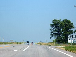
U.S. Route 54 is an east–west United States Highway that runs northeast–southwest for 1,197 miles (1,926 km) from El Paso, Texas, to Griggsville, Illinois. The Union Pacific Railroad's Tucumcari Line runs parallel to US 54 from El Paso to Pratt, Kansas, which comprises about two-thirds of the route. Truckers refer to this road as "The Bee Line."

<span class="mw-page-title-main">Lake of the Ozarks</span> Reservoir in Missouri, United States

Lake of the Ozarks is a reservoir created by impounding the Osage River in the northern part of the Ozarks in central Missouri. Parts of three smaller tributaries to the Osage are included in the impoundment: the Niangua River, Grandglaize Creek, and Gravois Creek. The lake has a surface area of 54,000 acres (220 km2) and 1,150 miles (1,850 km) of shoreline. The main channel of the Osage Arm stretches 92 miles (148 km) from one end to the other. The total drainage area is over 14,000 square miles (36,000 km2). The lake's serpentine shape has earned it the nickname "the Missouri Dragon", which has, in turn, inspired the names of local institutions such as the Magic Dragon Street Meet.

<span class="mw-page-title-main">Missouri Route 5</span> State highway in Missouri

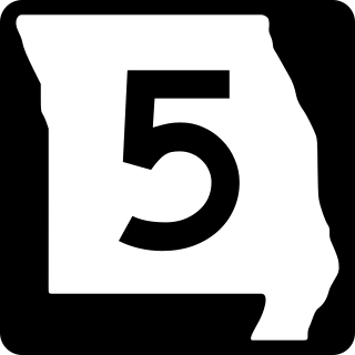
Missouri Route 5 is the longest state highway in Missouri and the only Missouri state highway to traverse the entire state. To the north, it continues into Iowa as Iowa Highway 5 and to the south it enters Arkansas as Arkansas Highway 5 as part of a three state 650 mile highway 5. With only a few exceptions, it is mostly a two-lane for its entire length.

<span class="mw-page-title-main">Missouri Route 13</span> State highway in Missouri

Route 13 is a highway in Missouri which runs almost the entire north–south length of the state. Its northern terminus is at U.S. Route 69/136 in Bethany. Its southern terminus is at the Arkansas state line in downtown Blue Eye, Missouri–Arkansas where it continues as Highway 21. It is one of the original state highways of Missouri.

<span class="mw-page-title-main">Missouri Route 7</span> State highway in Missouri

Route 7 is a state highway with its northern terminus at U.S. Route 24 in northeast Independence and its southern terminus at Interstate 44 southeast of Richland. The section between Harrisonville and Clinton provides an important link for traffic between Springfield and Kansas City.

<span class="mw-page-title-main">Missouri Route 52</span> State highway in Missouri, United States

Route 52 is an east/west highway running from its eastern terminus at Route 133 7 miles (11 km) east of St. Elizabeth to the Kansas state line where it continues as K-52. Highway 52 comprises 173 miles (278 km) of primarily two-lane roadway in Missouri.

<span class="mw-page-title-main">Illinois Route 13</span> State highway in Illinois, United States

Illinois Route 13 is a major east–west state route in southern Illinois. Illinois 13 has its western terminus at Centreville at Illinois Route 157 and its eastern terminus at the Kentucky state line and the Ohio River, at Kentucky Route 56. This is a distance of 151.54 miles (243.88 km).

<span class="mw-page-title-main">Missouri Route 42</span> State highway in Missouri

Route 42 is a highway in central Missouri. Its eastern terminus is at Route 28 south of Belle; its western terminus is at US 54 in Osage Beach.

<span class="mw-page-title-main">Wisconsin Highway 57</span> State highway in Wisconsin, United States

Wisconsin Highway 57 is a 191.82-mile-long (308.70 km) state highway in Wisconsin, United States. It runs from its southern terminus at WIS 59 in Milwaukee to its northern terminus at WIS 42 in Sister Bay. Much of WIS 57 parallels Interstate 43 (I-43) and WIS 42, particularly from Saukville to its northern terminus in Sister Bay. The highway runs concurrently with I-43 for 12 miles (19 km) in Ozaukee County. Like most Wisconsin state highways, WIS 57 is maintained by the Wisconsin Department of Transportation (WisDOT).

<span class="mw-page-title-main">U.S. Route 50 in Missouri</span> Segment of American highway

U.S. Route 50 (US 50) is a major east–west route in the state of Missouri. It is also known as the Rex M. Whitton Expressway in the capital of Missouri, Jefferson City.

<span class="mw-page-title-main">Interstate 44 in Missouri</span> Highway in Missouri

Interstate 44 (I-44) in the US state of Missouri runs northeast from the Oklahoma state line near Joplin to I-70 in Downtown St. Louis. It runs for about 293 miles (472 km) in the state, and is the longest Interstate Highway in the state.

James River Freeway is a 14-mile-long (23 km) freeway located largely on the south side of Springfield, Missouri. Its western terminus is at Interstate 44 (I-44) north of Brookline and its eastern terminus is at U.S. Route 65 (US 65) in southeastern Springfield. It is named for the James River, which passes near the highway at the freeway's eastern terminus. A total of four highways are routed on the highway: Route 360, US 60, US 160, Route 13, and Business US 65.

<span class="mw-page-title-main">U.S. Route 65 in Missouri</span> Highway in Missouri

U.S. Route 65 is a north–south U.S. highway that runs from Clayton, Louisiana to Albert Lea, Minnesota. In Missouri, the highway enters the state from Arkansas, just south of Branson. The highway exits the state into Iowa near South Lineville.

<span class="mw-page-title-main">Arkansas Highway 14</span> Highway in Arkansas

Highway 14 is an east–west state highway in Arkansas. The route of 227.35 miles (365.88 km) begins at Boat Dock Road near Table Rock Lake and runs east to Mississippi County Route W1020 (CR W1020) at Golden Lake. Segments of the highway are part of two Arkansas Scenic Byways: Sylamore Scenic Byway in the Ozark National Forest and the Crowley's Ridge Parkway atop Crowley's Ridge.

<span class="mw-page-title-main">Missouri Route 84</span> State highway in Missouri, United States

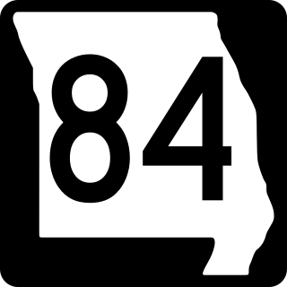
Route 84 is a state highway in the Missouri bootheel. The route starts at Arkansas Highway 90 over the St. Francis River on the Arkansas–Missouri state line. The road travels eastward to Kennett, where it becomes concurrent with U.S. Route 412. East of Kennett, the concurrent routes travel eastward on a divided highway to Hayti Heights, where the concurrency ends. Route 84 travels through Hayti Heights and Hayti, and it crosses Interstate 55 (I-55) and US 61. The route then travels southeastwards to Caruthersville, and bypasses the central area of the city. In the southern part of Caruthersville, Route 84 ends at an interchange with I-155 and US 412.

<span class="mw-page-title-main">Special routes of U.S. Route 65</span>

A total of eight special routes of U.S. Route 65 exist, divided between the U.S. states of Arkansas and Missouri. Currently, they are all business loops, although a spur route in Pine Bluff, Arkansas and bypass routes in Baton Rouge, Louisiana and Springfield, Missouri both existed in the past.

<span class="mw-page-title-main">Missouri Route 242</span> Short state highway in central Missouri

Missouri Route 242, also known as Horseshoe Bend Parkway, is a short highway in central Missouri found within Lake Ozark. The highway runs from the US 54 expressway junction near Osage Beach in Miller County in the east to Route MM in Camden County.

<span class="mw-page-title-main">U.S. Route 63 in Missouri</span> Section of U.S. Highway in Missouri, United States

U.S. Route 63 is the portion of a north-south highway that runs through the U.S. state of Missouri from the Arkansas state line near Thayer to the Iowa state line near Lancaster.

References

  1. 1 2 Missouri Department of Transportation (April 29, 2020). MoDOT HPMAPS (Map). Missouri Department of Transportation. Retrieved April 29, 2020.
  2. 1 2 "Hwy 54 History | Discover More on Route 54" . Retrieved January 23, 2016.
  3. "U.S. Route 54 Environmental Impact Study in Ralls, Pike, and Audrain | Missouri Department of Transportation". www.modot.org. Retrieved 2024-04-22.
  4. "National Highway System Maps | Missouri Department of Transportation". www.modot.org. Retrieved 2022-01-10.
  5. "St. Louis Post-Dispatch 09 Oct 2014, page Page A006". Newspapers.com. Retrieved 2023-01-04.
  6. Transportation, Missouri Department of. "New routes to open tonight on Highway 54 Expressway". LakeExpo.com. Retrieved 2021-10-10.
  7. Dabbs/LakeExpo.com, Janet. "New 54 and 242: So what happens next?". LakeExpo.com. Retrieved 2021-10-10.
  8. "New Route 54 interchange in Lake Ozark opens Wednesday, April 21". OzarkFirst.com. Retrieved April 22, 2021.
  9. "2020 Miller County Route 54/Osage Hills Road Interchange". Missouri Department of Transportation. Retrieved April 28, 2020.
  10. "I-70/Route 54 Kingdom City Interchange | Missouri Department of Transportation". www.modot.org. Retrieved 2023-06-19.
Template:Attached KML/U.S. Route 54 in Missouri
KML is not from Wikidata
US 54.svg U.S. Route 54
Previous state:
Kansas
Missouri Next state:
Illinois