Williamsport, Ohio

Last updated

Williamsport, Ohio
WilliamsportOH2.JPG
Water Street
OHMap-doton-Williamsport.png
Location of Williamsport, Ohio
Map of Pickaway County Ohio Highlighting Williamsport Village.png
Location of Williamsport in Pickaway County
Coordinates: 39°34′55″N83°07′28″W / 39.58194°N 83.12444°W / 39.58194; -83.12444
Country United States
State Ohio
County Pickaway
Township Deer Creek
Area
[1]
  Total1.80 sq mi (4.67 km2)
  Land1.77 sq mi (4.60 km2)
  Water0.03 sq mi (0.08 km2)
Elevation
[2]
768 ft (234 m)
Population
 (2020)
  Total970
  Density546.48/sq mi (210.97/km2)
Time zone UTC-5 (Eastern (EST))
  Summer (DST) UTC-4 (EDT)
ZIP code
43164
Area code 740
FIPS code 39-85414
GNIS feature ID2399697 [2]

Williamsport is a village in Pickaway County, Ohio, United States. The population was 970 at the 2020 census.

Contents

History

In 2022, the village blocked the development of the 400-megawatt Chipmunk Solar project, which would have become one of the largest renewable energy projects in the United States. With the cancellation of the solar power array, the village lost an estimated $3.6 million per year in tax revenue (most of which was intended for public schools). [3] [4]

Geography

According to the United States Census Bureau, the village has a total area of 1.84 square miles (4.77 km2), of which 1.81 square miles (4.69 km2) is land and 0.03 square miles (0.08 km2) is water. [5]

Demographics

Historical population
CensusPop.Note
1870 514
1880 313−39.1%
1890 36817.6%
1900 54748.6%
1910 536−2.0%
1920 5543.4%
1930 524−5.4%
1940 60515.5%
1950 6314.3%
1960 84033.1%
1970 8572.0%
1980 792−7.6%
1990 8517.4%
2000 1,00217.7%
2010 1,0232.1%
2020 970−5.2%
U.S. Decennial Census [6]

2010 census

As of the census [7] of 2010, there were 1,023 people, 342 households, and 272 families living in the village. The population density was 565.2 inhabitants per square mile (218.2/km2). There were 377 housing units at an average density of 208.3 per square mile (80.4/km2). The racial makeup of the village was 97.7% White, 0.3% African American, 0.2% Native American, 0.2% from other races, and 1.7% from two or more races. Hispanic or Latino people of any race were 0.3% of the population.

There were 342 households, of which 50.0% had children under the age of 18 living with them, 54.7% were married couples living together, 17.0% had a female householder with no husband present, 7.9% had a male householder with no wife present, and 20.5% were non-families. 17.0% of all households were made up of individuals, and 8.7% had someone living alone who was 65 years of age or older. The average household size was 2.99 and the average family size was 3.30.

The median age in the village was 30.5 years. 34% of residents were under the age of 18; 8.8% were between the ages of 18 and 24; 27.2% were from 25 to 44; 21.2% were from 45 to 64; and 8.8% were 65 years of age or older. The gender makeup of the village was 48.2% male and 51.8% female.

2000 census

As of the census [8] of 2000, there were 1,002 people, 355 households, and 275 families living in the village. The population density was 747.3 inhabitants per square mile (288.5/km2). There were 376 housing units at an average density of 280.4 per square mile (108.3/km2). The racial makeup of the village was 98.70% White, 0.70% African American, 0.20% Native American, 0.10% from other races, and 0.30% from two or more races. Hispanic or Latino people of any race were 0.10% of the population.

There were 355 households, out of which 44.8% had children under the age of 18 living with them, 55.8% were married couples living together, 19.2% had a female householder with no husband present, and 22.3% were non-families. 19.7% of all households were made up of individuals, and 9.6% had someone living alone who was 65 years of age or older. The average household size was 2.78 and the average family size was 3.19.

In the village, the population was spread out, with 32.2% under the age of 18, 7.4% from 18 to 24, 30.6% from 25 to 44, 20.5% from 45 to 64, and 9.3% who were 65 years of age or older. The median age was 32 years. For every 100 females there were 86.6 males. For every 100 females age 18 and over, there were 83.5 males.

The median income for a household in the village was $31,083, and the median income for a family was $32,292. Males had a median income of $28,333 versus $25,417 for females. The per capita income for the village was $14,115. About 20.0% of families and 22.7% of the population were below the poverty line, including 36.1% of those under age 18 and 20.2% of those age 65 or over.

Events

The village of Williamsport hosts the annual "Deer Creek Dam Days" festival on the final weekend of May. Events center around the Deercreek reservoir dam as well as rural lifestyles. [9]

Related Research Articles

<span class="mw-page-title-main">Halfway, Maryland</span> CDP in Maryland, United States

Halfway is a census-designated place (CDP) in Washington County, Maryland, United States. The population was 11,896 at the 2020 census. It is named due to its location, which is Halfway Between Hagerstown and Williamsport. As a major suburb of Halfway is part of the Hagerstown-Martinsburg, MD-WV, Metropolitan Statistical Area.

<span class="mw-page-title-main">Athens, Michigan</span> Village in Michigan, United States

Athens is a village in Calhoun County in the U.S. state of Michigan. The population was 936 at the 2020 census. The village is located in southern Athens Township, and is part of the Battle Creek, Michigan Metropolitan Statistical Area. It was settled in 1831.

<span class="mw-page-title-main">Miramiguoa Park, Missouri</span> Village in Missouri, United States

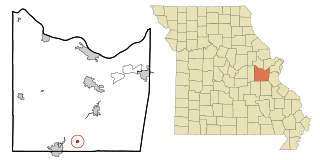
Miramiguoa Park is a village in Franklin County, Missouri, United States. The population was 120 at the 2010 census.

<span class="mw-page-title-main">Hillsdale, Missouri</span> Village in Missouri, United States

Hillsdale is a village in St. Louis County, Missouri, United States. Greenwood Cemetery is located in Hillsdale. The population was 1,478 at the 2010 census.

<span class="mw-page-title-main">Sycamore Hills, Missouri</span> Village in Missouri, United States

Sycamore Hills is a village in St. Louis County, Missouri, United States. The population is 560 at the 2020 census.

<span class="mw-page-title-main">Westwood, Missouri</span> Village in Missouri, United States

Westwood is a village in west St. Louis County, Missouri, United States. The population was 316 at the 2020 census.

<span class="mw-page-title-main">Walton Hills, Ohio</span> Village in Ohio, United States

Walton Hills is a village in Cuyahoga County, Ohio, United States. The population was 2,033 at the 2020 census. A suburb of Cleveland, it is a part of the Cleveland metropolitan area.

<span class="mw-page-title-main">Wayne Lakes, Ohio</span> Village in Ohio, United States

Wayne Lakes is a village in Darke County, Ohio, United States. The population was 693 at the 2020 census.

<span class="mw-page-title-main">Brice, Ohio</span> Village in Ohio, United States

Brice is a village in Franklin County, Ohio, United States, on the southeast side of the Columbus metropolitan area. The population was 93 at the 2020 census.

<span class="mw-page-title-main">Valleyview, Ohio</span> Village in Ohio, United States

Valleyview is a village in Franklin County, Ohio, United States. The population was 669 at the 2020 census.

<span class="mw-page-title-main">Addyston, Ohio</span> Village in Ohio, United States

Addyston is a village in Miami Township, Hamilton County, Ohio, United States. Located along the Ohio River, it is a western suburb of the neighboring city of Cincinnati. The population was 927 at the 2020 census.

<span class="mw-page-title-main">Sheffield, Ohio</span> Village in Ohio, United States

Sheffield is a village in Lorain County, Ohio, United States, along the Black River. The population was 4,135 at the 2020 census. It is part of the Cleveland metropolitan area.

<span class="mw-page-title-main">Haviland, Ohio</span> Village in Ohio, United States

Haviland is a village in Paulding County, Ohio, United States. The population was 160 at the 2020 census.

<span class="mw-page-title-main">Hartville, Ohio</span> Village in Ohio, United States

Hartville is a village in northern Stark County, Ohio, United States. The population was 3,329 at the 2020 census. It is part of the Canton–Massillon metropolitan area. Hartville lies halfway between Akron and Canton at the intersection of State Routes 43 and 619.

<span class="mw-page-title-main">Haskins, Ohio</span> Village in Ohio, United States

Haskins is a village in Wood County, Ohio, United States. The population was 1,245 at the 2020 census.

<span class="mw-page-title-main">Bellevue, Wisconsin</span> Village in Wisconsin, United States

Bellevue is a village in Brown County, Wisconsin. It was a town until incorporating as a village on February 14, 2003. The population was 15,935 at the time of the 2020 census. Bellevue is part of the Green Bay metropolitan area. Bellevue sits around 4.34 miles (6.99 km) east from central Green Bay.

<span class="mw-page-title-main">Avoca, Wisconsin</span> Village in Wisconsin, United States

Avoca is a village in Iowa County, Wisconsin, United States. The population was 637 at the 2010 census. It is part of the Madison Metropolitan Statistical Area. It is named after Avoca in Ireland.

<span class="mw-page-title-main">Verona, Ohio</span> Village in Ohio, United States

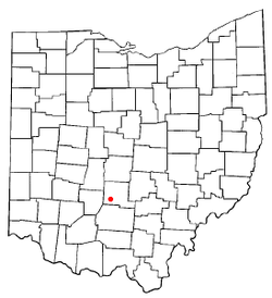
Verona is a village in Montgomery and Preble counties in the U.S. state of Ohio. The population was 403 at the 2020 census. It is part of the Dayton Metropolitan Statistical Area.

<span class="mw-page-title-main">Dorchester, Wisconsin</span> Village in Wisconsin, United States

Dorchester is a village in Clark and Marathon counties in the U.S. state of Wisconsin, along the 45th parallel. It is part of the Wausau, Wisconsin Metropolitan Statistical Area. The population was 876 at the 2010 census. Of this, 871 were in Clark County, and only 5 were in Marathon County.

<span class="mw-page-title-main">Dallas, Wisconsin</span> Village in Wisconsin, United States

Dallas is a village in Barron County in the U.S. state of Wisconsin. The population was 409 at the 2010 census. The village is located within the Town of Dallas.

References

  1. "ArcGIS REST Services Directory". United States Census Bureau. Retrieved September 20, 2022.
  2. 1 2 U.S. Geological Survey Geographic Names Information System: Williamsport, Ohio
  3. Gearino, Dan (July 29, 2022). "In rural Ohio, the energy transition runs into a ditch". ABC News. American Broadcasting Company. Retrieved January 15, 2023.
  4. Loeb, Vernon (December 22, 2022). "In the End, Solar Power Opponents Prevail in Williamsport, Ohio". Inside Climate News. Retrieved December 23, 2022.
  5. "US Gazetteer files 2010". United States Census Bureau . Retrieved January 6, 2013.
  6. "Census of Population and Housing". Census.gov. Retrieved June 4, 2015.
  7. "U.S. Census website". United States Census Bureau . Retrieved January 6, 2013.
  8. "U.S. Census website". United States Census Bureau . Retrieved January 31, 2008.
  9. Deercreek Dam Days Festival information