New Holland, Ohio | |
---|---|
Coordinates: 39°33′13″N83°15′20″W / 39.55361°N 83.25556°W | |
Country | United States |
State | Ohio |
Counties | Pickaway, Fayette |
Area | |
• Total | 1.96 sq mi (5.07 km2) |
• Land | 1.96 sq mi (5.07 km2) |
• Water | 0.00 sq mi (0.00 km2) |
Elevation | 853 ft (260 m) |
Population (2020) | |
• Total | 804 |
• Density | 410.62/sq mi (158.55/km2) |
Time zone | UTC-5 (Eastern (EST)) |
• Summer (DST) | UTC-4 (EDT) |
ZIP code | 43145 |
Area code | 740 |
FIPS code | 39-54726 [3] |
GNIS feature ID | 2399466 [2] |
Website | www |
New Holland is a village in Fayette and Pickaway counties in Ohio, United States. The population was 804 at the 2020 census.
The Pickaway County portion of New Holland is part of the Columbus Metropolitan Statistical Area, while the Fayette County portion is part of the Washington Court House Micropolitan Statistical Area.
The village was named after Holland, the native land of a share of the first settlers. [4]
According to the United States Census Bureau, the village has a total area of 1.88 square miles (4.87 km2), all land. [5]
Census | Pop. | Note | %± |
---|---|---|---|
1870 | 326 | — | |
1880 | 478 | 46.6% | |
1890 | 683 | 42.9% | |
1900 | 824 | 20.6% | |
1910 | 804 | −2.4% | |
1920 | 810 | 0.7% | |
1930 | 741 | −8.5% | |
1940 | 777 | 4.9% | |
1950 | 799 | 2.8% | |
1960 | 798 | −0.1% | |
1970 | 796 | −0.3% | |
1980 | 783 | −1.6% | |
1990 | 841 | 7.4% | |
2000 | 785 | −6.7% | |
2010 | 801 | 2.0% | |
2020 | 804 | 0.4% | |
U.S. Decennial Census [6] |
As of the census [7] of 2010, there were 801 people, 308 households, and 212 families living in the village. The population density was 426.1 inhabitants per square mile (164.5/km2). There were 363 housing units at an average density of 193.1 per square mile (74.6/km2). The racial makeup of the village was 97.6% White, 0.2% African American, 0.4% Native American, 0.2% Asian, 1.0% from other races, and 0.5% from two or more races. Hispanic or Latino people of any race were 1.0% of the population.
There were 308 households, of which 33.8% had children under the age of 18 living with them, 51.3% were married couples living together, 9.4% had a female householder with no husband present, 8.1% had a male householder with no wife present, and 31.2% were non-families. 22.4% of all households were made up of individuals, and 11.4% had someone living alone who was 65 years of age or older. The average household size was 2.60 and the average family size was 3.06.
The median age in the village was 41.2 years. 22.7% of residents were under the age of 18; 8.3% were between the ages of 18 and 24; 24.3% were from 25 to 44; 30% were from 45 to 64; and 14.5% were 65 years of age or older. The gender makeup of the village was 50.4% male and 49.6% female.
As of the census [3] of 2000, there were 785 people, 313 households, and 220 families living in the village. The population density was 420.1 inhabitants per square mile (162.2/km2). There were 331 housing units at an average density of 177.1 per square mile (68.4/km2). The racial makeup of the village was 97.58% White, 0.38% African American, 0.38% Native American, and 1.66% from two or more races. Hispanic or Latino people of any race were 0.25% of the population.
There were 313 households, out of which 29.7% had children under the age of 18 living with them, 56.2% were married couples living together, 10.2% had a female householder with no husband present, and 29.4% were non-families. 25.6% of all households were made up of individuals, and 16.0% had someone living alone who was 65 years of age or older. The average household size was 2.51 and the average family size was 3.00.
In the village, the population was spread out, with 24.5% under the age of 18, 8.2% from 18 to 24, 27.9% from 25 to 44, 23.4% from 45 to 64, and 16.1% who were 65 years of age or older. The median age was 37 years. For every 100 females there were 94.8 males. For every 100 females age 18 and over, there were 90.7 males.
The median income for a household in the village was $32,188, and the median income for a family was $36,696. Males had a median income of $30,625 versus $24,191 for females. The per capita income for the village was $15,613. About 4.4% of families and 7.9% of the population were below the poverty line, including 5.5% of those under age 18 and 14.7% of those age 65 or over.
Fayette County is a county located in the U.S. state of Ohio. As of the 2020 census, the population was 28,951. Its county seat and largest city is Washington Court House. The county was named for the Marquis de Lafayette, a Frenchman who was an officer in the American Army in the Revolution, when established on March 1, 1810.
Aberdeen is a village in Huntington Township, Brown County, Ohio, United States, along the Ohio River 50 miles (80 km) southeast of Cincinnati. The population was 1,515 at the 2020 census.
Gordon is a village in Darke County, Ohio, United States. The population was 245 at the 2020 census.
Yorkshire is a village in Darke County, Ohio, United States. The population was 95 at the 2020 census.
Lockbourne is a village in Franklin County and Pickaway County, Ohio, United States. The population was 236 at the 2020 census. Lockbourne is located near Rickenbacker International Airport, and had initially provided its original name of Lockbourne Air Force Base.
North Bend is a village in Miami Township, Hamilton County, Ohio, United States, along the Ohio River. It is a part of the Greater Cincinnati area. The population was 835 at the 2020 census.
Brinkhaven, once known as Mount Holly and Gann, is a village in Knox County, Ohio, United States. The population was 114 at the 2020 census.
Whitehouse is a village within the Toledo Metropolitan Area in Lucas County, Ohio, United States. The population was 4,990 at the 2020 census.
Montezuma is a village in Mercer County, Ohio, United States. The population was 152 at the 2020 census.
Commercial Point is a village in Pickaway County, Ohio, United States. The population was 3,078 at the 2020 census. It is the fastest-growing community in Pickaway County and one of the fastest-growing villages in central Ohio. It is a suburb of Columbus, OH
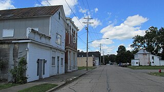
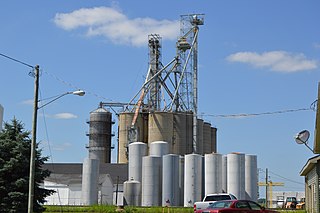
Darbyville is a village in Pickaway County, Ohio, United States. The population was 186 at the 2020 census.
Logan Elm Village is a census-designated place (CDP) in Pickaway County, Ohio, United States, near the site of the Logan Elm. The population was 1,062 at the 2000 census.
Orient is a census-designated place and former village in Pickaway County, Ohio, United States. The population was 246 at the 2020 census.
South Bloomfield is a village in Pickaway County, Ohio, United States. The population was 2,143 at the 2020 census. Since the 2000 census, it has consistently been one of the fastest-growing villages in central Ohio.
Tarlton is a village in Fairfield and Pickaway counties in the U.S. state of Ohio. The population was 254 at the 2020 census.
Williamsport is a village in Pickaway County, Ohio, United States. The population was 970 at the 2020 census.
Elgin is a village in Van Wert County, Ohio, United States. The population was 49 at the 2020 census. It is included within the Van Wert, Ohio Micropolitan Statistical Area.
Harrisburg is a village in Franklin and Pickaway counties in the U.S. state of Ohio. The population was 315 at the 2020 census.
Gratiot is a village in Licking and Muskingum counties in the U.S. state of Ohio. The population was 215 at the 2020 census.
Verona is a village in Montgomery and Preble counties in the U.S. state of Ohio. The population was 403 at the 2020 census. It is part of the Dayton Metropolitan Statistical Area.