1922 Austin twin tornadoes

Last updated

1922 Austin twin tornadoes
1922 Austin tornado paths.png
The paths of the two tornadoes across Austin
DurationMay 4, 1922 (May 4, 1922)
Tornadoes
confirmed
2
Max. rating1 F4 tornado
Fatalities12–13 fatalities; ≥50 injuries
Damage≥$300,000 (1922 USD) [nb 1]
Areas affected Austin, Texas, and surrounding communities
1Most severe tornado damage; see Fujita scale

On the afternoon of May 4, 1922, two simultaneous tornadoes struck Austin, Texas, taking unusual southwesterly paths through the city and surrounding areas on both sides of the Colorado River. Meteorological details concerning the conditions that led to the event are sparse, though historical accounts described the morning and afternoon as sweltering; clouds began aggregating northeast of Austin by noon and had developed into thunderstorms over the city by around 4:00 p.m. [nb 2] The first tornado began in a rural area 6 mi (9.7 km) northwest of the Texas State Capitol and tracked across the Texas Deaf, Dumb, and Blind Institute for Colored Youth and Deep Eddy, injuring at least five people and causing around $25,000 in damage (equivalent to $437,000in 2022). The tornado was widely photographed and was estimated to have been an F2 tornado on the Fujita scale.

Contents

While the first tornado was inflicting damage, a second tornado touched down near the Texas State Cemetery and moved across the Travis Heights community and St. Edwards University. Its most destructive impacts occurred at the Woodward Manufacturing Company's automobile plant at Penn Field. It then curved west towards Manchaca and Oak Hill, leveling homes and uprooting numerous trees before dissipating. The second tornado was the more destructive of the two and killed at least 12 people, including six at a single home in Oak Hill. It was estimated to have been an F4 tornado on the Fujita scale. In aggregate, the two tornadoes injured 50–60 people and inflicted at least $300,000 (equivalent to $5,200,000in 2022) in damage, with some estimates placing the damage toll above $700,000 (equivalent to $12,200,000in 2022).

Meteorological synopsis

A map of Austin in 1920 Austin TX 1920 map.jpg
A map of Austin in 1920

Two simultaneous tornadoes struck the Austin, Texas, area on the afternoon of May 4, 1922, inflicting a combined 50–60 injuries. Estimates of the damage toll vary widely. According to one estimate published in the University of Texas Bulletin, the tornadoes caused $300,000–$350,000 in property damage. [1] One estimate in the Weather Bureau's Climatological Data publication indicated a $500,000 damage toll. [2] The Austin American, a local newspaper, tallied a $584,000 toll, [3] :1 while another newspaper, The Austin Statesman, tallied a $725,000 toll. [4] :1 One tornado generally struck areas west of central Austin while the other struck areas east and south of the city; the latter caused all 12–13 fatalities documented on May 4. [5] [6] [7] The tornadoes were 4 mi (6.4 km) apart while on the ground. Both tornadoes took atypical tracks towards the south-southwest. [5] The Austin/San Antonio office of the National Weather Service ranked the event as the second most significant weather event of the 20th century for the Austin area, behind the flooding in 1921. [8] The meteorological details concerning the development and progression of the two tornadoes were primarily documented in two published accounts of the storm, with one authored by Frederic W. Simonds, the chairman of the Department of Geology at the University of Texas, and Fred Morris, a weather observer and employee at the university's mechanical engineering department. [5] [4] :1 The two tornadoes were also widely photographed, though the second, eastern tornado was imaged less. [5] A brief hailstorm with hail "of larger size than a pigeon egg" according to Simonds occurred after the two tornadoes struck, [1] lasting for about 20 minutes before the storms abated prior to sunset. [3] :2 To the north, the town of Taylor was buffeted by strong winds from a concurrent but separate storm. Round Rock and Hutto reported heavy rain during the afternoon but did not otherwise suffer any ill effects. Pflugerville reported small hailstones and rain. [3] :2

Simonds described May 4, 1922, as an "oppressively warm" day. [1] J.D. Martin, the superintendent at the Texas Deaf, Dumb, and Blind Institute for Colored Youth, described it as the onset of a heatwave shortly before the first tornado struck. [1] Likewise, Morris described the morning as "sultry" with a "very light southeast breeze" in his report published in the May 1922 edition of the Monthly Weather Review . [9] The air pressure on the University of Texas bottomed out at 986 mbar (986 hPa; 29.1 inHg) at 3:20 p.m. [1] Aside from the university barometer, there were no standard surface weather observations as climatological data was only recorded once per day at 7:00 a.m. Weather maps indicated the juxtaposition of drier air west of Austin and moist air from the Gulf of Mexico to the east. [5] Small and nearly stationary cumulus clouds began to form by 11:00 a.m. Some of these clouds to the northeast developed into cumulonimbus clouds by noon and remained stationary until around 2:30 p.m. when they began to move and spread south. After 3:00 p.m., low-level scud clouds began to converge over the Austin area, and at around 3:45 p.m. thunder was heard for the first time. Lightning became more frequent as the thunderstorm intensified. [9]

Tornadoes

First tornado

First Austin tornado
F2 tornado
Tornado in Austin, Texas (6938034274).jpg
The first tornado developing over west Austin
Max. rating1 F2 tornado
Fatalities7 injuries
Damage≥$25,000
1Most severe tornado damage; see Fujita scale

An account by Paul T. Seashore published in the Monthly Weather Review described the development of the conical funnel cloud that led to the first tornado on the afternoon of May 4: [10]

The approaching clouds were scarcely 5 miles away when I first became aware of the tornadic formative disturbance. In a position nearly due north a ragged edge, or that part which appears to an observer as being the bottom of the cloud had in one place dipped lower and had assumed the shape of a V with a slender thread-like appendage swinging from the bottom.

Paul T. Seashore, "Some Observations Made on the Origin, Growth, and Disappearance of the Tornado Which Passed West of Austin May 4, 1922", Monthly Weather Review (May 1922)

Simonds notes that a clamor began on the campus of the University of Texas as the funnel cloud began to descend to the northwest. [1] The commotion also led to the mid-game cancelation of a baseball match between the University of Texas and Austin College at Clark Field as well as the suspension of a special meeting of the Austin City Council. [11] [12] The funnel cloud was deflected 45 degrees away from the nadir below its connection with the parent cloud; Simonds believed this was a byproduct of wind currents passing through the rugged topography of the Balcones Escarpment west of Austin. [1] This first tornado touched down in a rural area 5–6 mi (8.0–9.7 km) northwest of the Texas State Capitol and moved south-southwest. [5] It destroyed several homes and caused heavy damage at the Texas Deaf, Dumb, and Blind Institute for Colored Youth, injuring five people. [1] [6] [4] :3 Buildings at the institute were either unroofed or displaced from their foundations; an industrial building, dormitory, laundry building, and smaller sheds were destroyed on the institution grounds. [1]

The tornado then blew down or unroofed cabins near Deep Eddy along the Colorado River and denuded or uprooted trees. [1] This included those on the nearby YMCA and Hardy Johnson campgrounds that were largely destroyed. [13] [4] :3 A segment of roofing ripped away from the institute landed at Deep Eddy after traveling airborne for 3 mi (4.8 km). [1] Two people were injured at Deep Eddy. The tornado then crossed the river and produced a narrow path of damage in unpopulated hills southwest of Austin before dissipating. [9] [6] An analysis of the tornado's damage published by meteorologist Thomas P. Grazulis in 1990 estimated that it was an F2 tornado on the Fujita scale, with a damage toll amounting to around $25,000; [6] The Austin Statesman attributed at least $50,000 in property damage to the tornado, including $40,000 incurred by the Texas Deaf, Dumb, and Blind Institute for Colored Youth. [3] :1 The tornado's path spanned 70 yd (64 m) at its widest and was 9 mi (14 km) long. [14]

Second tornado

Second Austin tornado
F4 tornado
Second Austin tornado of May 4, 1922 (Plate XVII).png
The second tornado as seen from the Main Building of the University of Texas, looking southwest
Max. rating1 F4 tornado
Fatalities12–13 fatalities, ≥50 injuries
Damage≥$300,000
1Most severe tornado damage; see Fujita scale

Morris's account of the second tornado detailed the development of the preceding wall cloud, writing of its "violent churning" and lowering from the broader cloud. [5] This tornado touched down near the Texas State Cemetery on the east side of Austin while the first tornado was in progress and initially moved south-southwest. Trees nearby were uprooted and stripped of their branches while some buildings sustained serious damage: [5] [1] one small home on Navasota Street was torn from its foundation and a Gulf Oil gas station on East Sixth Street was unroofed. [15] The tornado toppled a moonlight tower onto the Tenth Ward Fire Station, damaging the building. [1] [9] Along the Colorado River, small homes, and outbuildings were damaged as the tornado began to cross the river, [1] pulling a column of water 50 ft (15 m) into the air. [16] Waste from a nearby city landfill was also pulled into the river. [16] The tornado then entered the newly built Travis Heights community, where it unroofed houses and uprooted large trees. [1] Three homes were "wrecked" according to The Austin Statesman and four others were damaged. [4] :3 The tornado's impacts were not uniform; in some cases, badly damaged buildings were adjacent to those that showed little evidence of the tornado's passage. [1] At the time, the tornado spanned approximately 50 yd (46 m) across. [9] Additional homes were razed before the tornado moved across the campus of St. Edward's University. The third story of a brick dormitory was destroyed, in addition to the campus power plant and gymnasium. One university student was killed after being thrown 300 yd (270 m) by the tornado. [1] [17] [18] Another four students were injured. [4] :3 Grazulis lists the damage at the university as totaling approximately $200,000. [6] Debris from the tornado's passage over the campus was recovered as far as 55 mi (89 km) away. [1]

A water tower destroyed by the tornado Hornaday 1975 5150.jpg (15683273397).jpg
A water tower destroyed by the tornado

The greatest property toll occurred when the tornado tracked over Penn Field, where it destroyed the automobile plant of the Woodward Manufacturing Company; five large brick buildings were demolished and a steel water tower was toppled. Two people were killed there and twenty-eight others were injured. [1] [19] [20] [4] :1 Most of the casualties occurred at the facility's living quarters or planing mill; some were outside watching the tornado as it moved across Travis Heights when they were struck by debris. The Woodward Manufacturing Company assessed $300,000 in losses at the plant. [4] :3 Another person at Penn Field outside of the factory was also killed. [4] :1 Debris from the destruction at Penn Field was lofted over 100 ft (30 m) into the air and was blown onto the busy Post Road connecting Austin with San Antonio, Texas, but caused no loss of life. [1] [9] Additional debris broke through the roof of the St. Elmo schoolhouse; the building itself also moved at least 20 ft (6.1 m) off its foundation. [1] One person was killed in the St. Elmo area, [4] :1 which was reportedly "wiped out" by the tornado. [21] The tornado's path then curved towards the west, destroying a dairy and other buildings. [1] Two cows and a horse at the dairy were killed. [16] It was at this point that the tornado was at its widest, with a diameter of some 225 yd (206 m). [5] Two people were killed northwest of Manchaca. [6] Six people were killed in a single home 2 mi (3.2 km) southeast of Oak Hill; little remained of the home aside from the stones that once comprised its chimney. [1] Other small homes nearby were also leveled. [9] Tornadic damage after this point was largely inflicted upon farms and forests to the southwest, with swaths of fallen timber and debris resulting from the tornado's trek into more forested areas. [5] [1] Grazulis's 1991 assessment of the second tornado's damage estimated that it was an F4 tornado on the Fujita scale. [6] Estimates of the tornado's death and damage toll vary. Press reports and documentation published in the Monthly Weather Review list either 12 or 13 deaths. [7] [6] The May 5, 1922 edition of The Austin Statesman enumerated 13 fatalities and 44 injuries; [4] :1 the following day's edition enumerated 12 fatalities. [22] :2 The injured were sent to three area hospitals. [23] [24]

Aftermath

Damage toll reported by The Austin Statesman [22] :2
LocaleDamage
Woodward Manufacturing Company$400,000
St. Edward's University $250,000
Texas Deaf, Dumb, and Blind Institute for Colored Youth $30,000
Deep Eddy $15,000
Travis Heights $9,000
East Austin$7,500
Oak Hill $500
Other locations$5,000

The tornadoes cut off telecommunications with South Austin. [3] :2 Local chapters of the American Red Cross established a distribution center for relief supplies at the Austin Chamber of Commerce, appealing for donations of clothing and bedding from residents of Travis County. [25] Cash donations were also solicited by the chamber of commerce. [26] Hundreds of visitors took to the city from other towns to observe the devastation caused by the tornadoes. [27] Local firemen, police, members of the American Legion, and a detachment of the Texas Rangers secured the St. Edward's University campus and Penn Field to preserve property and belongings left behind by the storms. [4] :1 [28] The chambers of commerce of Dallas and San Antonio also offered to assist the city's recovery. [29]

Work crews were dispatched to clear debris around the city. [30] :1 The reconstruction and repair of damaged homes near Deep Eddy, in East Austin, and in the Travis Heights community began within a few days; [22] :2 in some cases, contracts for rebuilding were awarded before noon on May 5. [30] :1 St. Edward's University began a fundraising campaign to accrue $250,000 for repairs to campus buildings. [18] Students were housed in temporary quarters until the end of the school term in June following the damage to the dormitories. [22] :1 The Woodward Manufacturing Company, once a significant contributor to Austin's economy, transitioned into a furniture company after suffering extensive losses. [20] [18]

See also

Notes

  1. All monetary values in 1922  United States dollar unless otherwise noted.
  2. All times in Central Standard Time unless otherwise noted.

Related Research Articles

<span class="mw-page-title-main">1997 Central Texas tornado outbreak</span> Tornado outbreak in Texas

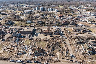
A deadly tornado outbreak occurred in Central Texas during the afternoon and evening of May 27, 1997, in conjunction with a southwestward-moving cluster of supercell thunderstorms. These storms produced 20 tornadoes, mainly along the Interstate 35 corridor from northeast of Waco to north of San Antonio. The strongest tornado was an F5 tornado that leveled parts of Jarrell, killing 27 people and injuring 12 others. Overall, 30 people were killed and 33 others were hospitalized by the severe weather.

<span class="mw-page-title-main">Ted Fujita</span> Japanese-American meteorologist (1920–1998)

Tetsuya Theodore Fujita was a Japanese American meteorologist whose research primarily focused on severe weather. His research at the University of Chicago on severe thunderstorms, tornadoes, hurricanes, and typhoons revolutionized the knowledge of each. Although he is best known for creating the Fujita scale of tornado intensity and damage, he also discovered downbursts and microbursts and was an instrumental figure in advancing modern understanding of many severe weather phenomena and how they affect people and communities, especially through his work exploring the relationship between wind speed and damage.

<span class="mw-page-title-main">1953 Waco tornado outbreak</span> United States meteorological event

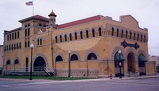
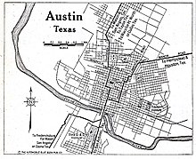
A deadly series of at least 33 tornadoes hit at least 10 different U.S. states on May 9–11, 1953. Tornadoes appeared daily from Minnesota in the north to Texas in the south. The strongest and deadliest tornado was a powerful F5 tornado that struck Waco, Texas on May 11, causing 114 of the 144 deaths in the outbreak. Alongside the 1902 Goliad tornado, it was the deadliest tornado in Texas history and is the 11th deadliest tornado in U.S. history. The tornado's winds demolished more than 600 houses, 1,000 other structures, and over 2,000 vehicles. 597 injuries occurred, and many survivors had to wait more than 14 hours for rescue. The destruction dispelled a myth that the geography of the region spared Waco from tornadoes, and along with other deadly tornadoes in 1953, the Waco disaster was a catalyst for advances in understanding the link between tornadoes and radar-detected hook echoes. It also generated support for improved civil defense systems, the formation of weather radar networks, and improved communications between stakeholders such as meteorologists, local officials, and the public.

<span class="mw-page-title-main">Lubbock tornado</span> 1970 F5 tornado in Lubbock, Texas

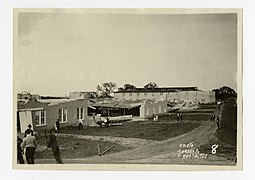
Portions of Lubbock, Texas, were struck by a powerful multiple-vortex tornado after nightfall on May 11, 1970, resulting in 26 fatalities and at least $135 million in damage. It was in its time the costliest tornado in U.S. history, damaging nearly 9,000 homes and inflicting widespread damage to businesses, high-rise buildings, and public infrastructure. The tornado's damage was surveyed by meteorologist Ted Fujita in what researcher Thomas P. Grazulis described as "the most detailed mapping ever done, up to that time, of the path of a single tornado." Originally, the most severe damage was assigned an F6 rating on the Fujita scale, making it one of only two tornadoes to receive the rating. Later, it was downgraded to an F5 rating after Fujita declared F6 damage was "inconceivable". The extremity of the damage and the force required to displace heavy objects as much as was observed indicated that winds produced by vortices within the tornado may have reached as high as 290 mph (470 km/h).

<span class="mw-page-title-main">1934 Atlantic hurricane season</span> Hurricane season in the Atlantic Ocean

The 1934 Atlantic hurricane season produced thirteen tropical storms, of which seven further organized into hurricanes. Of those seven hurricanes, only one intensified into a major hurricane, which is a Category 3 or stronger system on the modern-day Saffir–Simpson scale. The first system developed on June 4 while the last storm dissipated on November 30. In 2012, as part of the Atlantic hurricane reanalysis project, meteorologists identified two previously unknown September tropical storms and fine-tuned the meteorological histories of many others. However, given scant observations from ships and weather stations, significant uncertainty of tropical cyclone tracks, intensity, and duration remains, particularly for those storms that stayed at sea.

<span class="mw-page-title-main">Hurricane Audrey</span> Category 3 Atlantic hurricane in 1957

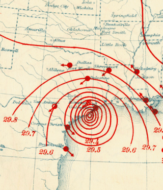
Hurricane Audrey was one of the deadliest hurricanes in U.S. history, killing at least 416 people in its devastation of the southwestern Louisiana coast in 1957. Along with Hurricane Alex in 2010, it was also the strongest June hurricane ever recorded in the Atlantic basin as measured by pressure. The rapidly developing storm struck southwestern Louisiana as an intense Category 3 hurricane, destroying coastal communities with a powerful storm surge that penetrated as far as 20 mi (32 km) inland. Audrey was the first named storm and hurricane of the 1957 hurricane season. It formed on June 24 from a tropical wave that moved into the Bay of Campeche. Situated within ideal conditions for tropical development, Audrey quickly strengthened, reaching hurricane status a day afterwards. Moving north, it continued to strengthen and accelerate as it approached the United States Gulf Coast. On June 27, the hurricane reached peak sustained winds of 125 mph (205 km/h), making it a major hurricane. At the time, Audrey had a minimum barometric pressure of 946 mbar. The hurricane made landfall with the same intensity between the mouth of the Sabine River and Cameron, Louisiana, later that day, causing unprecedented destruction across the region. Once inland, Audrey weakened and turned extratropical over West Virginia on June 29. Audrey was the first major hurricane to form in the Gulf of Mexico since 1945.

<span class="mw-page-title-main">1915 Galveston hurricane</span> Category 4 Atlantic hurricane

The 1915 Galveston hurricane was a tropical cyclone that caused extensive damage in the Galveston area in August 1915. Widespread damage was also documented throughout its path across the Caribbean Sea and the interior of the United States. Due to similarities in strength and trajectory, the storm drew comparisons with the deadly 1900 Galveston hurricane. While the newly completed Galveston Seawall mitigated a similar-scale disaster for Galveston, numerous fatalities occurred along unprotected stretches of the Texas coast due to the storm's 16.2 ft (4.9 m) storm surge. Overall, the major hurricane inflicted at least $30 million in damage and killed 403–405 people. A demographic normalization of landfalling storms suggested that an equivalent storm in 2005 would cause $68.0 billion in damage in the United States.

<span class="mw-page-title-main">1916 Texas hurricane</span> Category 4 Atlantic hurricane

The 1916 Texas hurricane was an intense and quick-moving tropical cyclone that caused widespread damage in Jamaica and South Texas in August 1916. A Category 4 hurricane upon landfall in Texas, it was the strongest tropical cyclone to strike the United States in three decades. Throughout its eight-day trek across the Caribbean Sea and Gulf of Mexico, the hurricane caused 37 fatalities and inflicted $11.8 million in damage.

The 1972 Portland–Vancouver tornadoes were caused by an unusually intense squall line with embedded strong tornadoes that struck Oregon and Washington on Wednesday, April 5, 1972. Of the four tornadoes, the most catastrophic event was a deadly F3 tornado that struck Portland, Oregon, and Vancouver, Washington, the first F3 tornado to strike Oregon since June 3, 1894. It tracked 8.7 miles (14.0 km) across the heavily populated Portland–Vancouver metropolitan area, causing heavy damage, killing six people, and injuring 300 while causing $25.25 million in damage. It was tied as the deadliest tornado in the United States in 1972 and remains the deadliest tornado in the history of the Pacific Northwest. In all, the outbreak killed six, injured 301, and caused $25.55 million in damage.

<span class="mw-page-title-main">Tornado outbreak sequence of April 2–5, 1957</span>

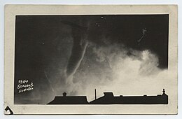
On April 2–5, 1957, a deadly tornado outbreak sequence struck most of the Southern United States. The outbreak killed at least 21 people across three states and produced at least 73 tornadoes from Texas to Virginia. The outbreak was most notable due to a tornado that hit a densely populated area of the Dallas–Fort Worth metropolitan area, killing 10 people and injuring 200 or more. The tornado, highly visible for most of its path, was at the time the most observed and best-documented tornado in recorded history; hundreds of people photographed or filmed the F3 tornado as it moved just west of Downtown Dallas. The film of this tornado is still known for its unusually high quality and sharpness, considering the photography techniques and technology of the 1950s. Damage from the Dallas tornado reached as high as $4 million. Besides the famous Dallas tornado, other deadly tornadoes struck portions of Mississippi, Texas, and Oklahoma. Two F4 tornadoes struck southern Oklahoma on April 2, killing five people. Three other significant, F2-rated tornadoes that day killed two people in Texas and one more in Oklahoma. An F3 tornado struck rural Mississippi on April 4, killing one more person.

<span class="mw-page-title-main">Tornado outbreak sequence of May 2003</span>

From May 3 to May 11, 2003, a prolonged and destructive series of tornado outbreaks affected much of the Great Plains and Eastern United States. Most of the severe activity was concentrated between May 4 and May 10, which saw more tornadoes than any other week-long span in recorded history; 335 tornadoes occurred during this period, concentrated in the Ozarks and central Mississippi River Valley. Additional tornadoes were produced by the same storm systems from May 3 to May 11, producing 363 tornadoes overall, of which 62 were significant. Six of the tornadoes were rated F4, and of these four occurred on May 4, the most prolific day of the tornado outbreak sequence; these were the outbreak's strongest tornadoes. Damage caused by the severe weather and associated flooding amounted to US$4.1 billion, making it the costliest U.S. tornado outbreak of the 2000s. A total of 50 deaths and 713 injuries were caused by the severe weather, with a majority caused by tornadoes; the deadliest tornado was an F4 that struck Madison and Henderson counties in Tennessee, killing 11.

A deadly tornado outbreak devastated parts of Louisiana and Tennessee on February 11–13, 1950. The outbreak covered about a day and a half and produced numerous tornadoes, mostly from East Texas to the lower Mississippi Valley, with activity concentrated in Texas and Louisiana. Most of the deaths occurred in Louisiana and Tennessee, where tornadoes killed 25 and nine people, respectively. Several long-lived tornado families struck the Red River region of northwestern Louisiana, especially the Shreveport–Bossier City area. One of the tornadoes attained violent intensity, F4, on the Fujita scale and caused eight deaths, including six at the Shreveport Holding and Reconsignment Depot near Barksdale Air Force Base. It remains one of the top ten deadliest tornadoes on record in the state of Louisiana, in tenth place. Also in Louisiana, two other destructive tornadoes on parallel paths killed 16. Seven additional deaths occurred across the border in East Texas. Nine people died in a tornado in western Tennessee as well. In all, the entire outbreak killed at least 41 people and left 228 injured. Also, several long-tracked tornadoes recorded in the outbreak likely contained more, shorter-lived tornadoes.

<span class="mw-page-title-main">Tornadoes of 1962</span>

This page documents the tornadoes and tornado outbreaks of 1962, primarily in the United States. Most tornadoes form in the U.S., although tornadoes events can take place internationally. Tornado statistics for older years like this often appear significantly lower than modern years due to fewer reports or confirmed tornadoes.

<span class="mw-page-title-main">Tornadoes of 2019</span>

This page documents notable tornadoes and tornado outbreaks worldwide in 2019. Strong and destructive tornadoes form most frequently in the United States, Argentina, Brazil, Bangladesh, and Eastern India, but can occur almost anywhere under the right conditions. Tornadoes also develop occasionally in southern Canada during the Northern Hemisphere's summer and somewhat regularly at other times of the year across Europe, Asia, Argentina, and Australia. Tornadic events are often accompanied by other forms of severe weather, including strong thunderstorms, strong winds, and hail.

<span class="mw-page-title-main">1944 Jamaica hurricane</span> Category 3 Atlantic hurricane in 1944

The 1944 Jamaica hurricane was a deadly major hurricane that swept across the Caribbean Sea and Gulf of Mexico in August 1944. Conservative estimates placed the storm's death toll at 116. The storm was already well-developed when it was first noted passing westward over the Windward Islands into the Caribbean Sea on August 16. A ship near Grenada with 74 occupants was lost, constituting a majority of the deaths associated with the storm. The following day, the storm intensified into a hurricane, reaching its peak strength on August 20 with maximum sustained winds of 120 mph (195 km/h). At this intensity, the major hurricane made landfall on Jamaica later that day, traversing the length of the island. The damage wrought was extensive, with the strong winds destroying 90 percent of banana trees and 41 percent of coconut trees in Jamaica; the overall damage toll was estimated at "several millions of dollars". The northern coast of Jamaica saw the most severe damage, with widespread structural damage and numerous homes destroyed across several parishes. In Port Maria, the storm was considered the worst since 1903.

<span class="mw-page-title-main">Tornadoes of 1952</span>

This page documents the tornadoes and tornado outbreaks of 1952, primarily in the United States. Most tornadoes form in the U.S., although some events may take place internationally. Tornado statistics for older years like this often appear significantly lower than modern years due to fewer reports or confirmed tornadoes.

A widespread, destructive, and deadly tornado outbreak sequence affected the Southeastern United States from April 28 to May 2, 1953, producing 24 tornadoes, including five violent F4 tornadoes. The deadliest event of the sequence was an F4 tornado family that ravaged Robins Air Force Base in Warner Robins, Georgia, on April 30, killing at least 18 people and injuring 300 or more others. On May 1, a pair of F4 tornadoes also struck Alabama, causing a combined nine deaths and 15 injuries. Additionally, another violent tornado struck rural Tennessee after midnight on May 2, killing four people and injuring eight. Additionally, two intense tornadoes impacted Greater San Antonio, Texas, on April 28, killing three people and injuring 20 altogether. In all, 36 people were killed, 361 others were injured, and total damages reached $26.713 million (1953 USD). There were additional casualties from non-tornadic events as well, including a washout which caused a train derailment that injured 10.

<span class="mw-page-title-main">February 13–17, 2021, North American winter storm</span> Category 3 winter storm and ice storm in the United States

A major winter and ice storm had widespread impacts across the United States, Northern Mexico, and parts of Canada from February 13 to 17, 2021. The storm, unofficially referred to as Winter Storm Uri by the Weather Channel, started out in the Pacific Northwest and quickly moved into the Southern United States, before moving on to the Midwestern and Northeastern United States a couple of days later.
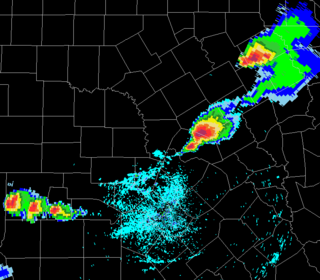
<span class="mw-page-title-main">Tornadoes of 2022</span> List of notable tornadoes occurring in 2022

This page documents notable tornadoes and tornado outbreaks worldwide in 2022. Strong and destructive tornadoes form most frequently in the United States, Argentina, Brazil, Bangladesh, and Eastern India, but can occur almost anywhere under the right conditions. Tornadoes also develop occasionally in southern Canada during the Northern Hemisphere's summer and somewhat regularly at other times of the year across Europe, Asia, Argentina, Australia and New Zealand. Tornadic events are often accompanied by other forms of severe weather, including strong thunderstorms, strong winds, and hail.

This page documents the tornadoes and tornado outbreaks of 1946, primarily in the United States. Most recorded tornadoes form in the U.S., although some events may take place internationally. Tornado statistics for older years like this often appear significantly lower than modern years due to fewer reports or confirmed tornadoes.

References

  1. 1 2 3 4 5 6 7 8 9 10 11 12 13 14 15 16 17 18 19 20 21 22 23 24 Simonds, Frederic W. (February 15, 1923). The Austin, Texas, Tornadoes of May 4, 1922 (Report). University of Texas Bulletin. Austin, Texas: University of Texas. Retrieved February 26, 2021 via Google Books.
  2. Bunnemeyer, Bernard (May 1922). "Texas Section" (PDF). Climatological Data. Houston, Texas: Weather Bureau. 27 (5). Archived from the original (PDF) on February 26, 2021. Retrieved February 26, 2021 via National Centers for Environmental Information.
  3. 1 2 3 4 5 "Cyclones Kill 10". The Austin American. Vol. 8, no. 330. Austin, Texas. May 5, 1922. pp. 1–2. Retrieved February 26, 2021 via Newspapers.com.
  4. 1 2 3 4 5 6 7 8 9 10 11 12 "13 Dead; 44 Injured". The Austin Statesman. Vol. 50, no. 338. Austin, Texas. May 5, 1922. pp. 1–3. Retrieved February 26, 2021 via Newspapers.com.
  5. 1 2 3 4 5 6 7 8 9 10 Curtis, Lon (January 8, 2018). Lessons We Must Learn—Deadly Tornadoes in Central Texas (PDF). 16th History Symposium. Austin, Texas: American Meteorological Society . Retrieved February 26, 2021.
  6. 1 2 3 4 5 6 7 8 Grazulis, T. P. (1990). "1922". Significant tornadoes, 1880-1989. St. Johnsbury, Vermont: Environmental Films. pp. 173–174. ISBN   1879362023 via Google Books.
  7. 1 2 "Severe Local Storms". Monthly Weather Review. Weather Bureau. 50 (5): 268. May 1922. Bibcode:1922MWRv...50..268.. doi: 10.1175/1520-0493(1922)50<268:SLS>2.0.CO;2 via American Meteorological Society. Open Access logo PLoS transparent.svg
  8. "Top 10 Most Significant Weather Events of the 1900s for Austin, Del Rio and San Antonio and Vicinity" (PDF). New Braunfels, Texas: National Weather Service Austin/San Antonio TX. December 28, 1999. Retrieved February 26, 2021.
  9. 1 2 3 4 5 6 7 Morris, Fred (May 1922). "The Austin Tornado of May 4, 1922". Monthly Weather Review. Weather Bureau. 50 (5): 251–253. Bibcode:1922MWRv...50..251M. doi: 10.1175/1520-0493(1922)50<251:TATOM>2.0.CO;2 via American Meteorological Society. Open Access logo PLoS transparent.svg
  10. Seashore, Paul T. (May 1922). "Some Observations Made on the Origin, Growth, and Disappearance of the Tornado Which Passed West of Austin May 4, 1922". Monthly Weather Review. Weather Bureau. 50 (5): 253. Bibcode:1922MWRv...50..253S. doi: 10.1175/1520-0493(1922)50<253a:SOMOTO>2.0.CO;2 via American Meteorological Society.
  11. "Wind Disrupts Council Meet; Officials Watch". The Austin American. Vol. 8, no. 330. Austin, Texas. May 5, 1922. p. 2. Retrieved February 26, 2021 via Newspapers.com.
  12. "Storm Breaks Up Baseball Game; Fans Scramble For Cover". The Austin Statesman. Vol. 50, no. 338. Austin, Texas. May 5, 1922. p. 3. Retrieved February 26, 2021 via Newspapers.com.
  13. "Deep Eddy Is Damaged When Twister Hits". The Austin Statesman. Vol. 8, no. 330. Austin, Texas. May 5, 1922. p. 1. Retrieved February 26, 2021 via Newspapers.com.
  14. Kimmel, Troy M. Jr. (February 2012). Inclement / Severe Weather and Extreme Temperature / Precipitation / Wildfire / Wind / Pressure / Fog / Sunshine Climatology for the Greater Austin Metropolitan Area (PDF) (Report) (5 ed.). Austin, Texas: University of Texas. p. 7. Retrieved February 26, 2021.
  15. "Tornado Skirts East Austin; Considerable Damage Done There". The Austin Statesman. Vol. 50, no. 338. Austin, Texas. May 5, 1922. p. 1. Retrieved February 26, 2021 via Newspapers.com.
  16. 1 2 3 "Eastern Wind Does Greatest Austin Damage". The Austin American. Vol. 8, no. 330. Austin, Texas. May 5, 1922. p. 2. Retrieved February 26, 2021 via Newspapers.com.
  17. Baston, Rose V.; Dunn, William H. "St Edward's University". Handbook of Texas. Austin, Texas: Texas State Historical Association. Retrieved February 26, 2021.
  18. 1 2 3 Jones, T.Q. (March 3, 2010). "Old Oak Hill: Oak Hill Family swept away by Austin's killer tornado of 1922". Oak Hill Gazette. Austin, Texas. Archived from the original on October 1, 2011. Retrieved February 26, 2021.
  19. Leatherwood, Art. "Penn Field". Handbook of Texas. Austin, Texas: Texas State Historical Association. Retrieved February 26, 2021.
  20. 1 2 "Zoning Change Review Sheet" (PDF). Austin, Texas: City of Austin. January 12, 2016. Retrieved February 26, 2021.
  21. "St-Elmo Wiped Out; Number of Persons Slightly Injured". The Austin Statesman. Vol. 50, no. 338. Austin, Texas. May 5, 1922. p. 3. Retrieved February 26, 2021 via Newspapers.com.
  22. 1 2 3 4 "The Woodward Plant to Be Rebuilt". The Austin Statesman. Vol. 50, no. 339. Austin, Texas. May 6, 1922. pp. 1–2. Retrieved February 27, 2021 via Newspapers.com.
  23. "Casualties Total Fifty-Seven". The Austin Statesman. Vol. 50, no. 338. Austin, Texas. May 5, 1922. p. 1. Retrieved February 26, 2021 via Newspapers.com.
  24. South Congress Avenue Preservation Plan (Report). Austin, Texas: McGraw Marburger & Associates. February 2002.
  25. "Relief Headquarters Opened; Red Cross in Charge of Work". The Austin Statesman. Vol. 50, no. 338. Austin, Texas. May 5, 1922. p. 1. Retrieved February 26, 2021 via Newspapers.com.
  26. "Generous Aid Given Austin Storm Victims". The Austin American. Vol. 8, no. 332. Austin, Texas. May 7, 1922. p. 2. Retrieved February 27, 2021 via Newspapers.com.
  27. "Reconstruction of Woodward Factory Will Be Hastened". The Austin Statesman. Vol. 50, no. 340. Austin, Texas. May 7, 1922. p. 1. Retrieved February 27, 2021 via Newspapers.com.
  28. "Ranger Company Guards at Penn". The Austin Statesman. Vol. 8, no. 330. Austin, Texas. May 5, 1922. p. 1. Retrieved February 26, 2021 via Newspapers.com.
  29. "Austin Citizens Respond With Gifts For Stricken". The Austin American. Vol. 8, no. 331. Austin, Texas. May 6, 1922. p. 2. Retrieved February 27, 2021 via Newspapers.com.
  30. 1 2 "Debris Yields Two More Bodies; Death Total 12; Workmen Clear Cutter". The Austin American. Vol. 8, no. 331. Austin, Texas. May 6, 1922. pp. 1, 3. Retrieved February 27, 2021 via Newspapers.com.