Minnesota has a humid continental climate, with hot summers and cold winters. Minnesota's location in the Upper Midwest allows it to experience some of the widest variety of weather in the United States, with each of the four seasons having its own distinct characteristics. The area near Lake Superior in the Minnesota Arrowhead region experiences weather unique from the rest of the state. The moderating effect of Lake Superior keeps the surrounding area relatively cooler in the summer and warmer in the winter, giving that region a smaller yearly temperature variation. On the Köppen climate classification, much of the southern third of Minnesota—roughly from the Twin Cities region southward—falls in the hot summer zone (Dfa), and the northern two-thirds of Minnesota falls in the warm summer zone (Dfb).

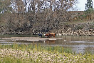
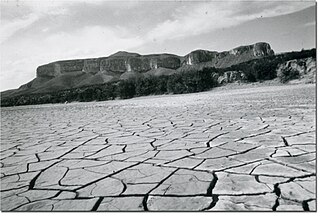
Drought in Australia is defined by the Australian Bureau of Meteorology as rainfall over period greater than three-months being in the lowest decile of what has been recorded for that region in the past. This definition takes into account that drought is a relative term and rainfall deficiencies need to be compared to typical rainfall patterns including seasonal variations. Specifically, drought in Australia is defined in relation to a rainfall deficiency of pastoral leases and is determined by decile analysis applied to a certain area. Note that this definition uses rainfall only because long-term records are widely available across most of Australia. However, it does not take into account other variables that might be important for establishing surface water balance, such as evaporation and condensation.

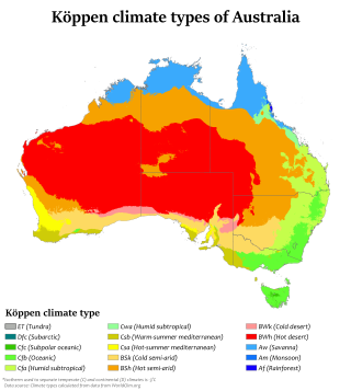
Australia's climate is governed mostly by its size and by the hot, sinking air of the subtropical high pressure belt. This moves north-west and north-east with the seasons. The climate is variable, with frequent droughts lasting several seasons, thought to be caused in part by the El Niño-Southern Oscillation. Australia has a wide variety of climates due to its large geographical size. The largest part of Australia is desert or semi-arid. Only the south-east and south-west corners have a temperate climate and moderately fertile soil. The northern part of the country has a tropical climate, varying between grasslands and desert. Australia holds many heat-related records: the continent has the hottest extended region year-round, the areas with the hottest summer climate, and the highest sunshine duration.

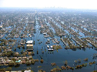
Floods in the United States (2000–present) is a list of flood events which were of significant impact to the country during the 21st century, since 2000. Floods are generally caused by excessive rainfall, excessive snowmelt, storm surge from hurricanes, and dam failure.

The climate of the north and central parts of the U.S. state of Florida is humid subtropical. South Florida has a tropical climate. There is a defined rainy season from May through October when air-mass thundershowers that build in the heat of the day drop heavy but brief summer rainfall.
In Australia, the Federation Drought is the name given to a prolonged period of drought that occurred around the time of Federation in 1901.
Between 1979 and 1983 almost all of eastern Australia was affected by a major drought.

The climate of New York (state) is generally humid continental, while the extreme southeastern portion of the state lies in the warmer humid subtropical climate zone. Winter temperatures average below freezing during January and February in much of the state of New York, but several degrees above freezing along the Atlantic coastline, including New York City.

The United States' contiguous western and especially southwestern region has experienced widespread drought since about year 2000. Below normal precipitation leads to drought, and is caused by an above average persistence of high pressure over the affected area. Changes in the track of extratropical cyclones, which can occur during climate cycles such as the El Niño-Southern Oscillation, or ENSO, as well as the North Atlantic Oscillation, Pacific Decadal Oscillation, and Atlantic multidecadal oscillation, modulate which areas are more prone to drought. Increased drought frequency and severity is also expected to be one of the effects of global warming.
The 1911–16 Australian drought consisted of a series of droughts that affected various regions of Australia between the years of 1911 and 1916. Most of the dry spells during this period can be related to three El Niño events in 1911, 1913 and 1914, though rainfall deficiencies actually began in northern Australia before the first of these El Niños set in and did not ease in coastal districts of New South Wales until well after the last El Niño had firmly dissipated and trends toward very heavy rainfall developed in other areas of the continent.

Droughts are a relatively common feature of the weather in the United Kingdom, with one around every 5–10 years on average. These droughts are usually during the summer, when a blocking high causes hot, dry weather for an extended period. However this means that droughts can vary in their characteristics. All types of drought cause issues across all sectors, with impacts extending to the ecosystem, agriculture and the economy of the whole country in severe cases of drought. The south east of the country usually suffers most, as it has the highest population and the lowest average precipitation per year, which is even lower in a drought. Even in these areas in severe droughts, the definition, impacts, effects and management are all minimal in comparison to drought prone areas such as Australia and parts of the United States. In recent years however, the summers of 2007, 2008, 2009, August 2010 and 2012 were wetter than normal, 2007 being wettest on record. Droughts have continued to occur in recent times, with spring 2011, July 2013, summer 2018, spring 2020, spring and summer 2022 and May and June 2023 all featuring excessively dry periods for part or all of the UK, and will likely become more severe due to climate change over the 21st century.

The 2000s drought in Australia, also known as the millennium drought, is said by some to be the worst drought recorded since European settlement.

The 2010–2013 Southern United States and Mexico drought was a severe to extreme drought that plagued the Southern United States, including parts of Texas, Louisiana, Arkansas, Mississippi, Alabama, Georgia, South Carolina, North Carolina, Florida, and Oklahoma; the Southwestern States, including Kansas, Colorado, New Mexico, and Arizona; as well as large parts of Mexico, in a three-year pattern from 2010 to 2013.

The 2012–2013 North American drought, an expansion of the 2010–2013 Southern United States drought, originated in the midst of a record-breaking heat wave. Low snowfall amounts in winter, coupled with the intense summer heat from La Niña, caused drought-like conditions to migrate northward from the southern United States, wreaking havoc on crops and water supply. The drought inflicted significant economic ramifications for the affected states. It exceeded, in many measures, the 1988–1989 North American drought, the most recent comparable drought.

The 2015–16 North American winter was not as frigid across North America and the United States as compared to the 2013–14 and 2014–15 winters. This was mainly due to a strong El Niño, which caused generally warmer-than-average conditions. However, despite the warmth, significant weather systems still occurred, including a snowstorm and flash flooding in Texas at the end of December and a large tornado outbreak at the end of February. The main event of the winter season, by far and large, was when a crippling and historic blizzard struck the Northeastern United States in late January, dumping up to 3 feet of snow in and around the metropolitan areas. Several other smaller snow events affected the Northeast as well, but for the most part the heaviest snowstorms and ice stayed out further west, such as a severe blizzard in western Texas in late December, and a major late-season snowstorm in Colorado in mid-April.

The 1950s Texas drought was a period between 1949 and 1957 in which the state received 30 to 50% less rain than normal, while temperatures rose above average. During this time, Texans experienced the second-, third-, and eighth-driest single years ever in the state – 1956, 1954, and 1951, respectively. The drought was described by a state water official as "the most costly and one of the most devastating droughts in 600 years."

Climate change in Alabama encompasses the effects of climate change, attributed to man-made increases in atmospheric carbon dioxide, in the U.S. state of Alabama.

A drought developed in the Western, Midwestern, and Northeastern United States in the summer of 2020. Similar conditions started in other states in August 2020, including Iowa, Nebraska and certain parts of Wisconsin and Minnesota. At the same time, more than 90% of Utah, Colorado, Nevada and New Mexico were in some level of drought. Also in drought conditions were Wyoming, Oregon and Arizona.

Since the beginning of March 2023, most of Canada experienced a drought, which was severe across the Prairie provinces and unprecedented in British Columbia. Every province and territory was in drought simultaneously. Common factors across Canada were a quick snow melt, sometimes due to a below-average snowpack, and the warmest May-June period in more than 80 years. Moderate to severe drought conditions from British Columbia to northern Ontario persisted until fall.


