27 Bryant

Last updated

27 Bryant
Muni worm logo.svg
Muni bus laying over on Cesar Chavez, March 2015.jpg
A 27 Bryant bus terminating on Cesar Chavez Street near Mission Street in 2015
Overview
Operator San Francisco Municipal Railway
GarageKirkland, Woods divisions
Vehicle New Flyer Xcelsior XDE40 (40 ft low-floor Diesel-Electric hybrid buses)
Began serviceAugust 24, 1983 (1983-08-24)
Route
Locale San Francisco, California
StartJackson and Van Ness
End 24th and Mission
Length5.7 miles (9.2 km)
Service
Frequency15m
Weekend frequency20m
Daily ridership6,200 (2019) [1]
Transfers25
Map 27 Bryant Map
  25 Treasure Island   List of San Francisco Municipal Railway lines   28 19th Avenue  

27 Bryant is a bus line operated by the San Francisco Municipal Railway. It connects Nob Hill to the Mission District via the Tenderloin and South of Market.

Contents

History

The line began service on August 24, 1983 as an amalgamation of the former 27 Noe and 25 San Bruno. [2]

Service was suspended between April 2020 and January 2021 due to the COVID-19 pandemic. [3] Around mid-August in 2020, Tenderloin residents rallied to demand the return of the 27 Bryant and 31 Balboa lines due to that neighborhood not having restored public transit. [4]

27 Bryant Transit Reliability Project

The 27 Bryant Transit Reliability Project is a project for reliability and traffic safety on the 27 line. This project focuses north of Market in the Tenderloin and Nob Hill neighborhoods where the 27 experiences many delays and extremely slow travel times. On April 16, 2019, the SFMTA Board of Directors approved this project. [5] [6]

In early September 2019, the SFMTA received a Core Values Award from the International Association for Public Participation (IAP2) USA for "Respect for Diversity, Inclusion and Culture." [7]

Phase 1

In August 2019, a permanent route change on the 27 went into effect on August 10, 2019, removing 11 stops and rerouting an outbound segment of the 27 line on Jones Street. [8]

COVID-19

Due to the COVID-19 pandemic, the scope of the project was adjusted in January 2021, which included the restoration of the 27 Bryant. The 27 was restored and the routing was modified on January 23, 2021, using the 19's temporary emergency transit lanes on 7th and 8th Streets to keep buses moving via traffic congestion and easily manage crowding. [9]

Route description

Operation

During the COVID-19 pandemic, service now operates between 6 a.m. to 10 p.m. every day. Service has no overnight Owl bus line when service is not in operation after 10 p.m. through midnight. The frequency is every 15 minutes on weekdays; the frequency is every 20 minutes on the weekends.

Bus stop listing

Prior to COVID-19
Inbound StopOutbound StopNeighborhoodsNotes and Connections
Jackson and Van Ness (Inbound terminus) Pacific Heights
Jackson and PolkPacific and Van Ness Nob Hill
Jackson and HydePolk and Washington
Leavenworth and JacksonWashington and Larkin
Leavenworth and ClayHyde and ClayAiga bus trans.svg Muni: 1
Leavenworth and Sacramento
Leavenworth and CaliforniaHyde and California BSicon CCAR.svg California Street line
Leavenworth and PineHyde and Pine
Leavenworth and BushBush and HydeServes the Saint Francis Memorial Hospital.
Leavenworth and SutterJones and Sutter
Leavenworth and PostJones and Post
Leavenworth and GearyJones and GearyInbound: Aiga bus trans.svg Muni: 38/38R | Outbound: Aiga bus trans.svg Muni: 38
Leavenworth and O'FarrellJones and O'Farrell Tenderloin Inbound: Aiga bus trans.svg Muni: 38 | Outbound: Aiga bus trans.svg Muni: 38/38R
Jones and Ellis
Ellis and JonesEddy and JonesOutbound: Aiga bus trans.svg Muni: 31
Ellis and TaylorEddy and Taylor
Ellis and MasonEddy and Mason
Cyril Magnin and Market
5th and Minna5th and Mission SoMa
5th and Howard
5th and Folsom
  • Aiga bus trans.svg Muni: 12
Harrison and 5th
Folsom and 6thAiga bus trans.svg Muni: 12
6th and BryantHarrison and 6th
7th and BryantHarrison and 7th
8th and BryantHarrison and 8th
9th and Bryant
11th and HarrisonAiga bus trans.svg Muni: 9, 9R, 12, 47, 90 Owl
Bryant and DivisionAiga bus trans.svg Muni: 9, 47, 90 Owl
Bryant and Alabama Mission District
Bryant and 16thAiga bus trans.svg Muni: 22, 33, 55
Bryant and 17thServes the KQED Television station and the Potrero Division.
Bryant and Mariposa
Bryant and 18th
Bryant and 19th
Bryant and 20th
Bryant and 21stThese stops are adjacent to the San Francisco General Hospital .
Bryant and 22nd
Bryant and 23rd
Bryant and 24thAiga bus trans.svg Muni: 48
Bryant and 25th
Bryant and 26th
Cesar Chavez and Florida
Cesar Chavez and HarrisonServes Leonard R. Flynn Elementary School and Precita Park.
Cesar Chavez and FolsomAiga bus trans.svg Muni: 12, 67
26th and South Van Ness
26th and Mission
Valencia and Cesar Chavez
Cesar Chavez and Bartlett

Related Research Articles

<span class="mw-page-title-main">San Francisco Municipal Railway</span> Public transport agency in San Francisco, California, USA

The San Francisco Municipal Railway (SF Muni or Muni), is the public transit system for the City and County of San Francisco. It operates a system of bus routes, the Muni Metro light rail system, three historic cable car lines, and two historic streetcar lines. Previously an independent agency, the San Francisco Municipal Railway merged with two other agencies in 1999 to become the San Francisco Municipal Transportation Agency (SFMTA). In 2018, Muni served 46.7 square miles (121 km2) with an operating budget of about $1.2 billion. Muni is the seventh-highest-ridership transit system in the United States, with 114,721,200 rides in 2022, and the second-highest in California after the Los Angeles County Metropolitan Transportation Authority.

<span class="mw-page-title-main">Muni Metro</span> Light rail system

Muni Metro is a light rail system serving San Francisco, California, United States. Operated by the San Francisco Municipal Railway (Muni), a part of the San Francisco Municipal Transportation Agency (SFMTA), Muni Metro served an average of 157,700 passengers per weekday in the fourth quarter of 2019, making it the second-busiest light rail system in the United States.

<span class="mw-page-title-main">N Judah</span> San Francisco light rail line

The N Judah is a hybrid light rail/streetcar line of the Muni Metro system in San Francisco, California. The line is named after Judah Street that it runs along for much of its length, named after railroad engineer Theodore Judah. It links downtown San Francisco to the Cole Valley and Sunset neighborhoods. It is the busiest line in the Muni Metro system, serving an average of 41,439 weekday passengers in 2013. It was one of San Francisco's streetcar lines, beginning operation in 1928, and was partially converted to modern light-rail operation with the opening of the Muni Metro system in 1980. While many streetcar lines were converted to bus lines after World War II, the N Judah remained a streetcar line due to its use of the Sunset Tunnel.
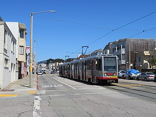
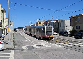
<span class="mw-page-title-main">M Ocean View</span> San Francisco light rail line

The M Ocean View is a hybrid light rail/streetcar line of the Muni Metro system in San Francisco, California. The line opened on October 6, 1925.

<span class="mw-page-title-main">K Ingleside</span> San Francisco light rail line

The K Ingleside is a hybrid light rail/streetcar line of the Muni Metro system in San Francisco, California. It mainly serves the West Portal and Ingleside neighborhoods. The line opened on February 3, 1918, and was the first line to use the Twin Peaks Tunnel.

<span class="mw-page-title-main">J Church</span> San Francisco light rail line

The J Church is a hybrid light rail/streetcar line of the Muni Metro system in San Francisco, California. The line runs between Embarcadero station and Balboa Park station through Noe Valley. Opened on August 11, 1917, it is the oldest and has the lowest ridership of all of the Muni Metro lines.

<span class="mw-page-title-main">S Shuttle</span> San Francisco light rail line

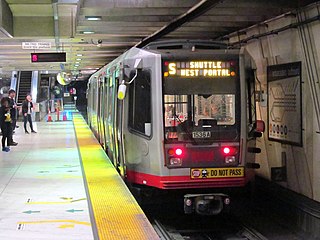
The S Shuttle is a light rail service on the Muni Metro system in San Francisco, California. The service began in 2001 as the S Castro Shuttle, an effort to reduce crowding at Castro station. It was briefly discontinued in 2007 when the T Third Street line was opened. Service was extended to St. Francis Circle station in 2013, but cut back to West Portal station in 2016. In 2020, it was changed to full-time service as part of a reconfiguration of Muni Metro service.

<span class="mw-page-title-main">San Francisco Municipal Transportation Agency</span> Government transportation agency in San Francisco, California

The San Francisco Municipal Transportation Agency is an agency created by consolidation of the San Francisco Municipal Railway (Muni), the Department of Parking and Traffic (DPT), and the Taxicab Commission. The agency oversees public transport, taxis, bicycle infrastructure, pedestrian infrastructure, and paratransit for the City and County of San Francisco.

<span class="mw-page-title-main">Market Street subway</span> BART-Muni Metro main line, San Francisco

The Market Street subway is a two-level subway tunnel that carries Muni Metro and BART trains under Market Street in San Francisco, California. It runs under the length of Market Street between Embarcadero station and Castro station. The upper level is used by Muni Metro lines and the lower level is used by BART lines. BART does not run through the whole subway; it turns south and runs under Mission Street southwest of Civic Center/UN Plaza station. The northeastern end of the BART level is connected to the Transbay Tube. On the Muni Metro level, the southwestern end of the Market Street subway connects to the much-older Twin Peaks Tunnel, and the northeastern end connects to surface tracks along the Embarcadero.

<span class="mw-page-title-main">Balboa Park station</span> Transit station in San Francisco, California, US

Balboa Park station is a Bay Area Rapid Transit (BART) station and Muni Metro complex in the Mission Terrace neighborhood of San Francisco, California, located near the eponymous Balboa Park. It is an intermodal hub served by four BART routes, three Muni Metro lines, and a number of Muni bus routes. The station complex also includes two rail yards, Cameron Beach Yard and Green Light Rail Center, where Muni maintains Muni Metro trains and heritage streetcars. BART uses a below-grade island platform on the west side of the complex; Muni Metro routes use several smaller side platforms located on surface-level rail loops around the yards.

<span class="mw-page-title-main">T Third Street</span> Light rail line

The T Third Street is a Muni Metro light rail line in San Francisco, California. It runs along the east side of San Francisco from Sunnydale to Chinatown, traveling in the median of Third Street for most of its length before entering the Central Subway as it approaches downtown. The line serves 22 stations, all of which are accessible. Most of the surface portion of the line runs in dedicated median lanes, though two portions operate in mixed traffic.

<span class="mw-page-title-main">Geary Bus Rapid Transit</span> Bus rapid transit project in San Francisco

The Geary Bus Rapid Transit project added bus rapid transit features to San Francisco Municipal Railway lines along Geary Boulevard. The corridor serves routes 38, 38R, 38AX, 38BX which combined to serve 52,900 daily riders in 2019, the most of any corridor in the city. The project added transit-only lanes, painted red, along many sections of Geary between the Transbay Transit Center and 33rd Avenue. After the project’s completion, over 75% of Geary corridor now has transit lanes.

<span class="mw-page-title-main">San Francisco Municipal Railway fleet</span> LRV and Bus Fleet of the San Francisco Municipal Railway (Muni)

With five different modes of transport the San Francisco Municipal Railway runs one of the most diverse fleets of vehicles in the United States. Roughly 550 diesel-electric hybrid buses, 300 electric trolleybuses, 250 modern light rail vehicles, 50 historic streetcars and 40 cable cars see active duty.

<span class="mw-page-title-main">San Jose and Ocean station</span>

San Jose and Ocean station is a light rail stop on the Muni Metro J Church line, located in the Mission Terrace neighborhood of San Francisco, California adjacent to the Balboa Park neighborhood and the Balboa Park station complex. The station has two side platforms in the middle of San Jose Avenue located before the intersection in each direction where passengers board or depart from trains. The station is not accessible to people with disabilities.

<span class="mw-page-title-main">Taraval and 19th Avenue station</span>

Taraval and 19th Avenue is a light rail stop on the Muni Metro L Taraval line, located in the Parkside neighborhood of San Francisco, California. The stop opened with the first section of the L Taraval line on April 12, 1919.

<span class="mw-page-title-main">Taraval and Sunset station</span>

Taraval and Sunset is a light rail stop on the Muni Metro L Taraval line, located in the Parkside neighborhood of San Francisco, California. The station opened with the second section of the L Taraval line on January 14, 1923.

<span class="mw-page-title-main">Taraval and 40th Avenue station</span>

Taraval and 40th Avenue is a light rail stop on the Muni Metro L Taraval line, located in the Parkside neighborhood of San Francisco, California, United States. The station opened with the second section of the L Taraval line on January 14, 1923.

<span class="mw-page-title-main">Taraval and 42nd Avenue station</span> Train station in San Francisco, California, U.S.

Taraval and 42nd Avenue is a light rail stop on the Muni Metro L Taraval line, located in the Parkside neighborhood of San Francisco, California. The station opened with the first section of the L Taraval line on January 14, 1923.

<span class="mw-page-title-main">Taraval and 44th Avenue station</span> Muni Metro station in San Francisco

Taraval and 44th Avenue is a light rail stop on the Muni Metro L Taraval line, located in the Parkside neighborhood of San Francisco, California. The station opened with the second section of the L Taraval line on January 14, 1923.

<span class="mw-page-title-main">31 Balboa</span> Trolleybus line operated by the San Francisco Municipal Railway

31 Balboa is a trolleybus line operated by the San Francisco Municipal Railway. It is one of several routes operating between the Financial District and the Richmond District.

References

  1. "Short Range Transit Plan" (PDF). San Francisco Municipal Transportation Agency. December 3, 2019. Archived (PDF) from the original on June 5, 2020. Retrieved December 27, 2021.
  2. Mitchell, Dave (August 17, 1983). "Muni to test-drive 16 routes — 3rd big change since 1979". San Francisco Examiner. p. 14. Retrieved February 17, 2022 via Newspapers.com. Lock-green.svg
  3. Sisto, Carrie (January 11, 2021). "27-Bryant bus service to return January 23 on a new route". Hoodline. Retrieved January 13, 2022.
  4. Graf, Carly (August 13, 2020). "Tenderloin residents rally to demand return of 27-Bryant and 31-Balboa buses". San Francisco Examiner. Retrieved January 13, 2022.
  5. Swan, Rachel (April 19, 2019). "27-Bryant, among the most sluggish of Muni bus lines, gets a makeover". San Francisco Chronicle. Retrieved January 13, 2022.
  6. "27 Bryant Transit Reliability Project". San Francisco Municipal Transportation Agency. February 23, 2018. Archived from the original on September 13, 2019. Retrieved December 13, 2021.
  7. "27 Bryant Project Wins IAP2 Outreach Award" (Press release). San Francisco Municipal Transportation Agency. September 10, 2019. Retrieved December 13, 2021.
  8. "Permanent Service Changes Effective August 10, 2019". San Francisco Municipal Transportation Agency. August 2, 2019. Archived from the original on September 29, 2020. Retrieved May 20, 2022.
  9. "Muni Expands Service, Access for Equity Neighborhoods in January". San Francisco Municipal Transportation Agency (Press release). Retrieved December 15, 2021.