Aba North

Last updated

Aba North
LGA
Nigeria location map.svg
Red pog.svg
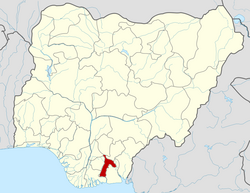
Aba North
Location in Nigeria
Coordinates: 5°20′N7°19′E / 5.333°N 7.317°E / 5.333; 7.317
Country Flag of Nigeria.svg Nigeria
State Abia State
Headquarters at:Eziama Urata
Government
  Local Government ChairmanChief Victor Ubani 
  Local Government Deputy ChairmanMrs. Joy Iwuchukwu
Area
  Total23 km2 (9 sq mi)
Population
 (2006 census)
  Total107,488
3-digit postal code prefix
450
ISO 3166 code NG.AB.AN
Aba North

Aba North is a Local Government Area in Aba, Abia State, Nigeria. [1] In the year (1991) Aba North local government was created. [2] The headquarters is at Eziama Uratta. [3] It is amongst the local governments that make up Abia South senatorial zone. [4] Aba North is in the South East geopolitical zone of Nigeria. The Igbo ethnic group is predominant in the area. [4] The people of the area are mostly Christians and traditional worshippers with Igbo and English as the commonly spoken languages. [5] Aba North, an integral part of Ngwaland, consists of indigenes and migrants from other parts of the state who reside in Aba for entrepreneurial and other purposes. [6] [7]

Contents

The postal code is 450. [8]

List of Towns and villages in Aba North

The towns and villages in Aba North include:

Economy

Aba North Local government area is home to the popular Ariaria International Market which is one of Africa’s biggest markets. [10]

Geography

Aba North has an estimated average temperature of 28 degrees Celsius and a humidity of 72%. The Local Government Area encompasses an estimated 23 km2 in total. [10]

Related Research Articles

<span class="mw-page-title-main">Abia State</span> State of Nigeria

Abia State is a state in the South-East geopolitical zone of Nigeria, it is bordered to the northwest by Anambra State and northeast by the states of Enugu, and Ebonyi, Imo State to the west, Cross River State to the east, Akwa Ibom State to the southeast, and Rivers State to the south. Abia is the only Southeastern state that has boundaries with the other four Southeastern states in Nigeria. It takes its name from the acronym for four of the state's most populated regions: Aba, Bende, Isuikwuato, and Afikpo. The state capital is Umuahia while the largest city and commercial centre is Aba.

<span class="mw-page-title-main">Aba, Nigeria</span> City in Abia, Nigeria

Aba is a city in southeastern Nigeria and the commercial centre of Abia State. Upon the creation of Abia State in 1991, the old Aba township was divided into two local government areas, being Aba South and Aba North, while the suburban neighborhood of what was then known as Obioma Ngwa L.G.A. was divided into three L.G.A.s for administrative convenience. Aba South is the main city centre of Aba and Abia State at large, being located on the Aba River. Aba is made up of many villages such as Aba-Ukwu, Eziukwu-Aba, Obuda-Aba, Umuokpoji-Aba and other villages that have been merged for administrative convenience. Aba was established by the Ngwa clan of the Igbo people in Nigeria as a market town. Later, a military post was placed there by the British colonial administration in 1901. It lies along the west bank of the Aba River and is at the intersection of roads leading to Port Harcourt, Owerri, Umuahia, Ikot Ekpene, and Ikot-Abasi. The city became a collection point for agricultural products following construction of a British-made railway running through it to Port Harcourt. Aba is a major urban settlement and commercial centre in its region, which is surrounded by small villages and towns. The indigenous people of Aba are the Ngwa. Aba is well known for its craftsmen and is the most populous city in southeastern Nigeria. As of 2016, Aba had an estimated population of 2,534,265, making it the biggest city in South Eastern Nigeria.

<span class="mw-page-title-main">Ebonyi State</span> State of Nigeria

Ebonyi State is a state in the South-East geopolitical zone of Nigeria, bordered to the north and northeast by Benue State, Enugu State to the west, Cross River State to the east and southeast, and Abia State to the southwest. Named for the Abonyi (Aboine) River—a large part of which is in the state's south—Ebonyi State was formed from parts of Abia and Enugu state in 1996 and has its capital in Abakaliki.

<span class="mw-page-title-main">Enugu State</span> State of Nigeria

Enugu State is a state in the South-East geopolitical zone of Nigeria, bordered to the north by the states of Benue and Kogi, Ebonyi State to the east and southeast, Abia State to the south, and Anambra State to the west. The state takes its name from its capital and largest city, Enugu. The city acquired township status in 1917 and was called Enugwu-Ngwo. Due to the rapid expansion towards areas owned by other indigenous communities, it was renamed Enugu in 1928.

<span class="mw-page-title-main">Orlu, Imo</span> LGA and city in Imo, Nigeria

Orlu is the second-largest city in South East, Imo State, Nigeria, with a population of 420,600. It has a long history as the headquarters for the Organisation of African Unity (OAU) and humanitarian relief agencies during the Nigeria-Biafra Civil War. The city houses the Nigerian headquarters of the British Cheshire Home. It is the second most developed city after Owerri in Imo state.

Nnewi South is a Local Government Area in Anambra South Senatorial Zone of Anambra State, Nigeria. Its population is approximately 1 million. Ukpor is the headquarters of Nnewi South.

<span class="mw-page-title-main">Imo State</span> State of Nigeria

Imo State is a state in the South-East geopolitical zone of Nigeria, bordered to the north by Anambra State, Rivers State to the west and south, and Abia State to the east. It takes its name from the Imo River which flows along the state's eastern border. The state capital is Owerri and the State's slogan is the "Eastern Heartland."

Bende is a Local Government Area in Abia State, Nigeria with headquarters located in Bende Community. Bende Local Government Area (L.G.A) of Abia state lies on 70 30I of the Greenwich Meridian and latitude 50 30I North of the Equator. It is composed of thirteen (13) communities, namely: Alayi, Bende, Ezukwu, Igbere, Item, Itumbuzo, Nkpa, Ntalakwu, Ozuitem, Ugwueke, Umu-imenyi, Umuhu-Ezechi, and Uzuakoli.

Ogbaru is a local government area in Anambra State, south-central Nigeria. The area's local government headquarters is in the port city of Atani.

Onitsha South is a Local Government Area in Anambrs North Senatorial zone of Anambra State, Nigeria. The headquarters is in Fegge, Onitsha. Onitsha South is predominantly commercial with popular markets such as Ochanja market which attracts thousands of buyers and sellers of variety of commodities. The revenue of Onitsha South Local Government Area is generated mostly from commercial activities.

Ohafia is an Igbo town in the Ohafia local government area (LGA) in Abia State, Nigeria. It is an Igbo speaking region. The ancestral capital of Ohafia town is the centrally located village of Elu. Ohafia Local Government Area, is an administrative jurisdiction assigned by the Nigeria Government, which covers the entire Ohafia villages and other towns such as Abiriba and Nkporo, with its Administrative Headquarters at Ebem Ohafia.

Oyigbo also known as Obigbo is a Local Government Area located in Rivers State, Nigeria. It is a town, 30 kilometers from the Port city of Port Harcourt, 25km from the city of Aba. It's predominantly inhabited by the Asa people an indigenous Igbo people who are also found in Ukwa west L.G.A in Abia state and the Ndoki people who are also found in Ukwa East L.G.A of Abia state and Ukanafun L.G.A of Akwa ibom state

Ikwuano is a Local Government Area of Abia State, Nigeria. Its headquarters is in Isiala Oboro. The name 'Ikwuano' etymologically indicates that there are four different ancient kingdoms that make up the community called Ikwuano. These include Oboro, Ibere, Ariam/Usaka and Oloko.

<span class="mw-page-title-main">Ukwa West</span> LGA in Abia State, Nigeria

Ukwa West is a Local Government Area in Abia State, Nigeria. Its headquarters is in the town of Oke Ikpe.

Umuahia North is a Local Government Area of Abia State, Nigeria. Its headquarters is in the city of Umuahia.

Ngor Okpala is a Local Government Area of Imo State, Nigeria. Its headquarters is in the town of Umuneke Ngor.

The Isu people are the second largest group of the Igbo people of Nigeria. Isuama, in which the purest Igbo is said to be spoken, is to be found the heart of the Igbo nationality; consequently it is quite reasonable to look among its people for the original fountain-head from which all the other clans have sprung. This inference too is supported not only by the purity of the language, but by this right of dispensing or rather of confer-ring royalty which is undoubtedly the prerogative of the Nri or N'shi people. In the pre-colonial era, the Igbo people were protected from external invasion by the dense forests of the region, which also had the effect of encouraging diversity. Thus as warriors the neighboring Oratta (Uratta) people looked down on the Isu people, who were traders.

Abayi Okoroato is a city in Obingwa local government area of Abia State, Nigeria.

Omoba is the Local Government Headquarters of Isiala Ngwa South, Abia State, Nigeria.

Ndoro is a town in Oboro, Ikwuano Local Government Area of Abia State, Nigeria. It is about 16 km southeast from the state capital, Umuahia and is located along the Umuahia-Ikot Ekpene Road.

References

  1. Brinkmann, Robert; Garren, Sandra J. (2018-04-30). The Palgrave Handbook of Sustainability: Case Studies and Practical Solutions. Springer. ISBN   978-3-319-71389-2.
  2. NigeriaGalleria (2021). "Brief History of Abia State".
  3. "Aba North LGA". www.finelib.com. Retrieved 2022-07-15.
  4. 1 2 Nigeria, Media (2018-02-22). "Senatorial Districts In Abia State". Media Nigeria. Retrieved 2022-07-15.
  5. Nigeria, Media (2022-02-15). "History Of Aba North LGA, Abia State". Media Nigeria. Retrieved 2022-07-15.
  6. admin (2014-11-24). "2015: Ukwa-Ngwa bloc and Abia politics". Businessday NG. Retrieved 2023-11-14.
  7. "About Us". www.ngwacommunityuk.org. Retrieved 2023-11-14.
  8. "Post Offices". NIPOST. Archived from the original on 7 October 2009. Retrieved 2009-10-20.
  9. "List of Towns and Villages in Aba North LGA". Nigeria Zip Codes. 2014-02-14. Retrieved 2022-07-15.
  10. 1 2 "Aba North Local Government Area". www.manpower.com.ng. Retrieved 2022-09-07.