
La Rioja ,spanish local pronunciation la ʂjoxa, is the capital and largest city of La Rioja Province, Argentina, located in the east of the province.

San Fernando del Valle de Catamarca is the capital and largest city in Catamarca Province in northwestern Argentina, on the Río Valle River, at the feet of the Cerro Ambato. The city name is normally shortened as Catamarca.

Monclova, is a city and the seat of the surrounding municipality of the same name in the northern Mexican state of Coahuila. According to the 2015 census, the city had 231,107 inhabitants. Its metropolitan area has 381,432 inhabitants and a population density of 29.88 inhabitants per square kilometer. Monclova is the third-largest city and metropolitan area in the state in terms of population, after Torreón and Saltillo.

Río Grande is a city in Argentina, on the north coast of the eastern part of the Isla Grande de Tierra del Fuego. It has a population of 98,017, and is the industrial capital of the Tierra del Fuego Province. It is located 212 kilometres (132 mi) north-east of Ushuaia, the capital of the province.

Tuxpan is both a municipality and city located in the Mexican state of Veracruz. The population of the city was 89,557 and of the municipality was 154,600 inhabitants, according to the INEGI census of 2020, residing in a total area of 1,051.89 km2 (406.14 sq mi). The municipality includes many smaller outlying communities, the largest of which are Alto Lucero and Santiago de la Peña. A local beachside community is also nearby.

San Luis is the capital city of San Luis Province in the Cuyo region of Argentina. It is also the seat of the Juan Martín de Pueyrredón Department.

Nuevo Casas Grandes is a city and the seat of the Nuevo Casas Grandes Municipality in northern Mexico. It is located in the northwestern part of the state of Chihuahua, on the Casas Grandes or San Miguel river, situated in a wide, fertile valley on the 4,000-foot Mesa del Norte of the Plateau of Mexico. Nearby is the Sierra Madre Occidental.

Ramos Arizpe is a city and seat of the surrounding municipality of the same name in the Mexican state of Coahuila. Ramos Arizpe is located 11 km from the state capital of Saltillo. It is part of the Saltillo metropolitan area. The city reported a population of 48,228 in the 2005 census; the municipality had a population of 56,708. Its area is 5,306.6 km2.
Tinogasta is a city in the west of the province of Catamarca, Argentina, on the right-hand shore of the Abaucán River, about 280 km from the provincial capital San Fernando del Valle de Catamarca. It had about 11,500 inhabitants at the 2010 census [INDEC]. It is the head town of the department of the same name. The name of the city comes from the Kakana words tino ("meeting") and gasta ("town").

San Rafael is a city in the southern region of the Mendoza Province, Argentina. With more than 118,000 inhabitants, it is the largest city in and the seat of San Rafael Department.

Apizaco is a city in Apizaco Municipality located near the geographic center of the Mexican state of Tlaxcala, approximately 25 minutes by car from the state's capital city of Tlaxcala. Those seeking to reach the port of Veracruz by railroad from Mexico City must travel through Apizaco. The city began because of its location on this railroad.

Heroica Ciudad de Huajuapan de León is a city with a surrounding municipality located in the northwestern part of the Mexican state of Oaxaca. It is part of the Huajuapan District in the north of the Mixteca Region. The municipality has a population of 78,318, the sixth-largest community in the state in population. It is located at the intersection of Federal Highways 125 and 190. The name of Huajuapan comes from the Nahuatl words huaxin = huaje, ohtli = road, and apan = river. Literally, River of the huajes. The town was elevated to an honorary Mexican status in June 1843 in remembrance of The siege of Huajuapan, a battle between the royal army and the insurgents led by José María Morelos. The battle was won by the insurgents. The city was named after Antonio de León, a hero of the Mexican War of Independence.
Bernardo de Irigoyen is a city in the province of Misiones, Argentina. It has 10,889 inhabitants as per the 2001 census [INDEC], and is the head town of the General Manuel Belgrano Department. It carries the name of prominent politician and diplomat Bernardo de Irigoyen.

Villa Dolores is a city in the province of Córdoba, Argentina, located in the southwestern side of the province. It has a population of 29,854 inhabitants.

The Servicio Meteorológico Nacional (SMN) is Mexico's national weather organization. It collects data and issues forecasts, advisories, and warnings for the entire country.

Concepción del Oro is one of the 58 municipalities in the Mexican state of Zacatecas. It is located on the northern part of the state and it is bounded by the municipalities of Mazapil and El Salvador; it also lies next to the states of Coahuila and San Luis Potosí. The municipality covers a total surface area of 2,559 square kilometers (988 sq mi).

The Bolsón de Mapimí is an endorheic, or internal drainage, basin in which no rivers or streams drain to the sea, but rather toward the center of the basin, often terminating in swamps and ephemeral lakes. It is located in the center-north of the Mexican Plateau. The basin is shared by the states of Durango, Coahuila, Chihuahua, and Zacatecas. It takes its name from Mapimí, a town in Durango.

Abasolo is a city located in the Mexican state of Tamaulipas. It is the seat of Abasolo Municipality.
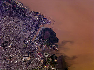
Buenos Aires, the capital of Argentina, has a temperate climate, which is classified as a humid subtropical climate (Cfa) under the Köppen climate classification with four distinct seasons. Summers are hot and humid with frequent thunderstorms while winters are cool and drier with frosts that occurs on average twice per year. Spring and fall are transition seasons characterized by changeable weather. At the central observatory, the highest temperature recorded is 43.3 °C (109.9 °F), and the lowest temperature recorded is −5.4 °C (22.3 °F).
Tanhuato is a municipality in the Mexican state of Michoacán, located approximately 135 kilometres (84 mi) northwest of the state capital of Morelia.

