Candela is a city in the central region (Región Centro) of the northern Mexican state of Coahuila. It is the municipal seat of the surrounding municipality of Candela. There were 1,669 inhabitants in 2000. In 2011, according to Wolfram Alpha, it had a population of 1,672.

Municipalities are the second-level administrative divisions of Mexico, where the first-level administrative division is the state. They should not be confused with cities or towns that may share the same name as they are distinct entities and do not share geographical boundaries. As of January 2021, there are 2,454 municipalities in Mexico, excluding the 16 boroughs of Mexico City. If all 16 boroughs of Mexico City is counted, the total of municipalities will be 2,470.
Tepehuanes Municipality is a municipality in the Mexican state of Durango. It is located in the North West of Durango at 25°12'"-26°25'"N 105°23'"-106°40'"W, at an elevation of about 1,830 meters (6000 feet).

Félix Candela Outeriño was a Spanish and Mexican architect who was born in Madrid and at the age of 26, emigrated to Mexico, acquiring double nationality.
Acayucan Municipality is a municipality in the Mexican state of Veracruz. It is located in the state's southeast, in the Olmeca region. The municipal seat is the city of Acayucan, Veracruz. It covers a total of 724.65 km².

Jerécuaro is a Mexican city located in the lowlands of the state of Guanajuato. The municipality has an area of 828.3 square kilometres and is bordered to the north by Apaseo el Alto, to the east by Coroneo and the state of Querétaro, to the south by Tarandacuao, to the southwest with Acámbaro, and to the northwest with Tarimoro. The municipality had 55,311 inhabitants according to the 2005 census. The municipal president of Jerécuaro and its many smaller outlying communities is C.Jaime García Cardona.
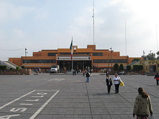
Nezahualcóyotl, or more commonly Neza, is a city and municipal seat of the municipality of Nezahualcóyotl in Mexico. It is located in the state of Mexico, adjacent to the east side of Mexico City. The municipality comprises its own intrastate region, Region IX.

Pinotepa Nacional is a city and seat of the municipality of the same name, in the Mexican state of Oaxaca. It is located in the Jamiltepec District in the west of the Costa Region. The name Pinotepa means "toward the crumbling hill" in Náhuatl.
Chalma is a municipality in the Mexican state of Veracruz.
El Higo is a municipality of the Mexican state of Veracruz. It is located in the state's Huasteca Alta region. The municipal seat is the village of El Higo, Veracruz.

Pánuco is a municipality in the Mexican state of Veracruz. It is located in the Huasteca Alta region of Veracruz and shares borders with the states of San Luis Potosí and Tamaulipas. The municipal seat is the city of Pánuco, Veracruz.
Cerro Azul Municipality is a municipality in the Mexican state of Veracruz. It is located in the state's Huasteca Baja region. The municipal seat is the city of Cerro Azul, Veracruz.
Pilcaya is one of the 81 municipalities of Guerrero, in south-western Mexico. The municipal seat lies at Pilcaya. The municipality covers an area of 62.1 km².
Xochistlahuaca Municipality is one of the 81 municipalities of Guerrero, in south-western Mexico. The municipal seat lies at Xochistlahuaca. The municipality covers an area of 321.1 km².
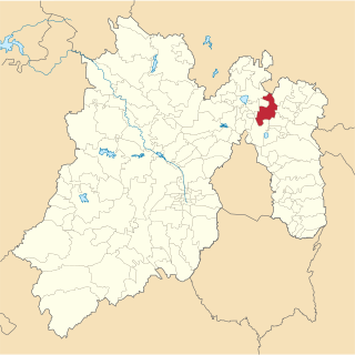
Tecámac is a municipality in State of Mexico in Mexico. The municipality covers an area of 157.34 km². The municipal seat lies in the town (locality) of Tecámac de Felipe Villanueva. Its largest town, Ojo de Agua, with a population of 242,283 inhabitants, is the largest locality in Mexico that is not a municipal seat.

Huaquechula Municipality is a municipality in Puebla in south-eastern Mexico.

Puebla Municipality is a municipality in the State of Puebla in eastern Central Mexico. The municipality covers a total area of 534.32 square kilometres (206.30 sq mi). The City of Puebla is the municipal seat, as well as the capital of the state.

Zacatlán Municipality is a municipality in the Mexican state of Puebla in south-eastern Mexico. Its administrative centre is the city of Zacatlán.
Álamos Municipality is a municipality in south-western Sonora, Mexico. It includes the town of Álamos.

Intibucá is a city, with a population of 28,220, and a municipality in the department of Intibucá, Honduras. The urban area of Intibucá is an important transit and commercial site in the South-West region of Honduras. Located 1,850 meters above sea level, Intibucá has a cool and often foggy climate, hence the nickname "La ciudad del manto blanco". Potato production, celebrated by the annual Festival de la Papa, is the principal basis of the economy for the municipality.


