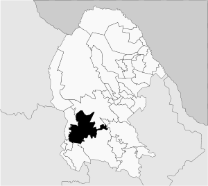
Chiapas is a state in Southwest Mexico. According to the 2015 Mexican Intercensal Survey, it is the state that has the seventh largest population with 5,217,908 inhabitants and the 10th largest by land area spanning 73,560.47 square kilometres (28,401.86 sq mi). Chiapas is officially divided into 124 municipalities, although the establishment of municipal authorities in Belisario Domínguez has been suspended since 2015 pending the resolution of a territorial dispute between Chiapas and the neighbouring state of Oaxaca. A 125th municipality called Honduras de la Sierra, consisting of six ejidos currently part of Siltepec, will be incorporated on October 1, 2018.

El Porvenir is a municipio (municipality) and township in the Mexican state of Chiapas.
San Pedro Lagunillas is both a municipality and the municipal seat of the same in the Mexican state of Nayarit. The population of the municipality was 7,155 (2005) in a total area of 520 square kilometers. The population of the town and municipal seat was 3,630 (2005). The population has been declining since 1980 when it was 8,308 inhabitants.

Almoloya de Juárez is a town in the State of Mexico and the seat of the municipality of Almoloya de Juárez. The name Almoloya comes from the Nahuatl, that is properly Almoloyan, composed of: atl, "water"; molo "impersonal voice of moloni, to flow the source" and yan, "place"; that it means "place where flows the water source".

Zapotlán de Juárez is a town and one of the 84 municipalities of Hidalgo, in central-eastern Mexico. The municipality covers an area of 131.1 km².
Santo Tomás de los Plátanos also known as Nuevo Santo Tomás de los Plátanos is a town and governmental seat of the municipality of Santo Tomás, located in the center-west of Mexico State, in Mexico. It is approximately 185 km from Mexico City, and 107 km from Toluca.
Temascalcingo de José María Velasco is a town and seat of the municipality of Temascalcingo in the State of Mexico, Mexico. It is located in the northeast of the state. The temazcal was very common in Temascalcingo. The name Temascalcingo has its roots in Nahuatl. It means place of the little temazcal. The town is one of the "Pueblo con Encanto" of the State of Mexico.
Chalma Municipality is one of the 212 municipalities of the Mexican state of Veracruz.

Mapimí is one of the 39 municipalities of Durango, in north-western Mexico. The municipal seat lies at Mapimí. The municipality covers an area of 7,126.7 km².

Otáez is one of the 39 municipalities of Durango, in north-western Mexico. The municipal seat lies at Otáez. The municipality covers an area of 906.5 km².

San Pedro del Gallo is one of the 39 municipalities of Durango, in north-western Mexico. The municipal seat lies at San Pedro del Gallo. The municipality covers an area of 2,008.3 km².

Atengo is both a small village and municipality of the region Sierra de Amula in the Mexican state Jalisco.
San Pedro Ocotepec is a town and municipality in Oaxaca in south-western Mexico. The municipality covers an area of 136.51 km². It is part of the Sierra Mixe district within the Sierra Norte de Oaxaca Region.

San Pedro Teozacoalco is a town and municipality in Oaxaca, in south-western Mexico. It is part of the Nochixtlán District in the southeast of the Mixteca Region.
San Pedro y San Pablo Tequixtepec is a town and municipality in Oaxaca in south-western Mexico. The municipality covers an area of km². Having the longest place name in Mexico, it is part of the Huajuapan District in the north of the Mixteca Region.
San Pedro y San Pablo Teposcolula is a town and municipality in Oaxaca in south-western Mexico. The municipality covers an area of km². It is part of the Teposcolula District in the center of the Mixteca Region
San Pedro de la Cueva Municipality is a municipality in Sonora in north-western Mexico.
Tepache Municipality is a municipality in Sonora in north-western Mexico.

Pochutla District is located in the east of the Costa Region of the State of Oaxaca, Mexico. The primary city is San Pedro Pochutla.

Progreso Municipality is one of the 106 municipalities in the Mexican state of Yucatán containing (270.10 km2) of land and located roughly 25 km north of the city of Mérida.