
Asientos is a municipality in the Mexican state of Aguascalientes. It stands at 22°14′N102°05′W. The town of Real de Asientos serves as the municipal seat for the surrounding municipality of Asientos.

Comala is a town and municipality located in the Mexican state of Colima, near the state capital of Colima. It has been nicknamed the "White Village of America" as the façades of the buildings in town have all been painted white since the 1960s. The historic center of the town was declared a Historic Monument Zone and the town became a Pueblo Mágico in 2002. It is the municipal seat of the Comala Municipality, the local governing authority for over 400 other communities, including the former Nogueras Hacienda, the home of artist Alejandro Rangel Hidalgo.

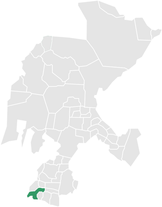
Nochistlán is a city in the Mexican state of Zacatecas. Nuño Beltrán de Guzmán, on December 3, 1531, hired Cristóbal de Oñate to establish a village in Nochistlán; the village would be named Guadalajara to honor Guzmán for having been born in Guadalajara. Guadalajara was founded in Nochistlán on January 5, 1532. Its first officials were Cristóbal de Oñate, Sancho Ortiz de Zúñiga, Juan de Albornoz and Miguel de Ibarra. They worked at this project for only 16 months and created the first layout of Guadalajara.
Parras de la Fuente is a city located in the southern part of the Mexican state of Coahuila. The city serves as the municipal seat of the surrounding Parras Municipality, which has an area of 9,271.7 km2 (3,579.8 sq mi).

Mineral del Monte, commonly called Real del Monte or El Real, is a small mining town, and one of the 84 municipalities of Hidalgo, in the State of Hidalgo in east-central Mexico.
Teúl de González Ortega Municipality is a town and municipality located in the south of the Mexican state of Zacatecas, between the state capital of Zacatecas and the city of Guadalajara. Unlike most of the rest of the state, its economy has been based on agriculture and livestock, rather than mining, and it is noted for its production of agave and mezcal. The town has been named a Pueblo Mágico to promote a tourism industry.
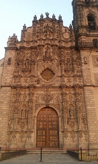
Tepotzotlán is a city and a municipality in the Mexican state of Mexico. It is located 40 km (25 mi) northeast of Mexico City about a 45-minute drive along the Mexico City-Querétaro at marker number 41. In Aztec times, the area was the center of a dominion that negotiated to keep most of its independence in return with being allied with the Aztec Triple Alliance. Later, it would also be part of a "Republic of the Indians," allowing for some autonomy under Spanish rule as well. The town became a major educational center during the colonial period when the Jesuits established the College of San Francisco Javier. The college complex that grew from its beginnings in 1580 would remain an educational center until 1914. Today this complex houses the Museo del Virreinato, with one of the largest collections of art and other objects from this time period.
Aculco is a municipality located in the Atlacomulco Region of the State of Mexico in Mexico. The name comes from Nahuatl. The municipal seat is the town of Aculco de Espinoza, although both the town and municipality are commonly referred to as simply "San Jerónimo Aculco".

Aculco de Espinoza or San Jerónimo Aculco is a town and municipal seat of the Aculco Municipality, State of Mexico in Mexico.

The Programa Pueblos Mágicos is an initiative led by Mexico's Secretariat of Tourism, with support from other federal agencies, to promote a series of towns around the country that offer visitors "cultural richness, historical relevance, cuisine, art crafts, and great hospitality". It is intended to increase tourism to more localities, especially smaller towns in rural areas.

Nombre de Dios is a city and seat of the municipality of Nombre de Dios, established as Pueblo Mágico on October 11, 2018, in the state of Durango, north-western Mexico. As of 2015, the town of Nombre de Dios had a population of 5,302.
Tecozautla is a town and one of the 84 municipalities of Hidalgo, in central-eastern Mexico. The municipality covers an area of 575.6 km². The name derives from the Nahuatl words "tetl", meaning "stone"; "cozaqui", meaning "yellow thing"; and "tla", meaning "place of"; making the entire meaning of Tecozautla "place where yellow earth abounds".

Zempoala is a town and one of the 84 municipalities of Hidalgo, in central-eastern Mexico. The municipality covers an area of 319.78 km². The name Zempoala derives from the Nahuatl roots "Cempoalli", meaning "twenty" and "tlan", meaning "place"; giving Zempoala the meaning of "place of twenties", referring to the market held every twenty days.
Zimapán is a town and one of the 84 municipalities of Hidalgo, in central-eastern Mexico. The municipality covers an area of 860.9 km2 (332.4 sq mi).

Mascota is a town and municipality in Jalisco, in central-western Mexico. The municipality covers an area of 1,843 km². The name Mascota comes from the root "Amaxacotlán", which means "place of deer and colubrids".

Tapalpa is a town and municipality in Jalisco, a state of central-western Mexico.

Capulálpam de Méndez is a town and municipality in the Sierra Juárez in Oaxaca in south-western Mexico. It is part of the Ixtlán District in the Sierra Norte de Oaxaca region. The name "Capulálpam" in Nahuatl means "land of the chokecherry tree," a common type of tree in the area. In 2005 the population was 1,313.

Pahuatlán, officially Pahuatlán del Valle, is a town and municipality located in the northwest of the state of Puebla in central Mexico. The municipality is part of the Sierra Norte region of the state, a steep mountainous area which receive significant moisture from the Gulf of Mexico, and borders the states of Hidalgo and Veracruz.
Catorce is a municipality in the Mexican state of San Luis Potosí in central Mexico. The municipal seat is the pueblo mágico of Real de Catorce.
The Programa Pueblos Mágicos is an initiative led by Ecuador's Ministry of Tourism (MINTUR). The program seeks to promote tourism in a network of small and mid-sized towns that represent aspects of Ecuador's cultural heritage, and to encourage sustainable economic development in these communities. It is based on the Mexican government's program of the same name.


