
The Sierra Nevada is a mountain range in the Western United States, between the Central Valley of California and the Great Basin. The vast majority of the range lies in the state of California, although the Carson Range spur lies primarily in Nevada. The Sierra Nevada is part of the American Cordillera, an almost continuous chain of mountain ranges that forms the western "backbone" of the Americas.

Mount Whitney is the highest mountain in the contiguous United States, with an elevation of 14,505 feet (4,421 m). It is in East–Central California, in the Sierra Nevada, on the boundary between California's Inyo and Tulare counties, and 84.6 miles (136.2 km) west-northwest of North America's lowest topographic point, Badwater Basin in Death Valley National Park, at 282 ft (86 m) below sea level. The mountain's west slope is in Sequoia National Park and the summit is the southern terminus of the John Muir Trail, which runs 211.9 mi (341.0 km) from Happy Isles in Yosemite Valley. The eastern slopes are in Inyo National Forest in Inyo County. Mount Whitney is ranked 18th by topographic isolation.

Mount Hopkins is a mountain in the John Muir Wilderness north of Kings Canyon National Park. It is one of four peaks that surround Pioneer Basin, 1.4 miles (2.3 km) south-southeast of Mount Crocker, 2 miles (3.2 km) west-southwest of Mount Huntington, and 2 miles (3.2 km) southwest of Mount Stanford. The mountain was named for Mark Hopkins, one of the builders of the Central Pacific Railroad.

Black Kaweah is a mountain of the Kaweah Peaks Ridge of the California's Sierra Nevada, in Sequoia National Park. The peak has a local magnetic disturbance that has caused compasses in the vicinity to vary by up to eight degrees. Fulgurites can be found on the peak.

Mount Kaweah is a mountain in California's Sequoia National Park and forms part of the Kaweah Peaks Ridge, a spur of the Great Western Divide which extends south from Triple Divide Peak. It has a summit elevation of 13,807 ft (4,208 m), the highest along the Kaweah Peaks Ridge.

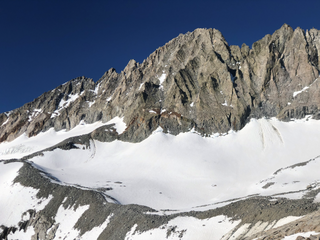
Mount Sill is one of the fourteeners of the Sierra Nevada in California. It is located in the Palisades, a group of prominent rock peaks with a few small glaciers on their flanks. Mount Sill is located 0.6 miles (1 km) east of North Palisade, the high point of the group. The two peaks are connected by a high, rocky ridge, on the north side of which lies the Palisade Glacier. Mount Sill lies on the main Sierra Crest, but is at a point where the crest turns sharply, giving it particularly striking summit views. On one side is Kings Canyon National Park and Fresno County; on the other is the John Muir Wilderness, Inyo National Forest and Inyo County.

Mount Langley is a mountain located on the crest of the Sierra Nevada, on the boundary between Inyo and Tulare counties in eastern California, in the United States. To the east is the Owens Valley, and to the west is the Kern River Valley. It is the ninth-highest peak in the state and the seventh-highest in the Sierra. Mount Whitney, the highest peak in the contiguous United States, lies 4.8 miles (7.7 km) to the northwest. Mount Langley also has the distinction of being the southernmost fourteener in the United States.

Split Mountain is a fourteener in the Sierra Nevada of the U.S. state of California, near the southeast end of the Palisades group of peaks. It is the only fourteener in the watershed of the South Fork Kings River, and it rises to 14,064 feet (4,287 m), making it the eighth-highest peak in the state.
Middle Palisade is a 14,018-foot (4,273-meter) peak in the central Sierra Nevada mountain range in the U.S. state of California. It is a fourteener, and lies on the Sierra Crest as part of the Palisades group, a group of prominent Sierra Nevada mountain summits that includes multiple other fourteeners, approximately 12 miles (19 km) southwest of the town of Big Pine. Middle Palisade is the twelfth highest peak in California.

Banner Peak is the second tallest peak in the Ritter Range of California's Sierra Nevada. The mountain is 12,942 feet (3,945 m) tall, and there are several glaciers on its slopes. It lies within the boundaries of the Ansel Adams Wilderness; at the foot of the peak lie Garnet Lake, Lake Ediza, and the famous Thousand Island Lake. Banner Peak is near the town of Mammoth Lakes; from there, climbers can hike to the foot of the mountain where various routes reach the summit, the easiest of which is a class 2 from the west end of Thousand Island Lake and then the saddle between Banner Peak and the slightly taller Mount Ritter. Other nearby lakes include Lake Catherine and Shadow Lake.

Mount Agassiz, at 13,899 feet (4,236 m), is one of the 20 highest peaks of California. It is the northernmost and easiest to climb of the major Palisades summits. This peak is not to be confused with the 9,967-foot (3,038 m) peak by the same name in Desolation Wilderness, also in the California Sierra.

Table Mountain is located near the northern end of the Great Western Divide, a sub-range of the Sierra Nevada in California. The summit marks a point on the boundary between Sequoia and Kings Canyon national parks and is 0.6 miles (1 km) south of Thunder Mountain and 1.3 miles (2.1 km) northeast of Midway Mountain.

Mount Hoffmann is a prominent peak in northeastern Mariposa County in the center of Yosemite National Park, California, United States. It rises above May Lake and is a day hike of 6.2 miles (10.0 km) (one-way) from Tioga Pass Road. The mountain is named for the cartographer Charles F. Hoffmann, who was part of the California Geological Survey of the Sierra Nevada.

Norman Clyde Peak, standing 13,861 feet (4,225 m) tall, is in natural company among the high peaks of the Palisades region of the Sierra Nevada in California. It raises on the main ridge of the Palisades', between Middle Palisade and Palisade Crest. Norman Clyde Glacier on its north face, and Middle Palisade Glacier on its east both feed the headwaters of the South Fork of Big Pine Creek. It is named posthumously for mountaineer Norman Clyde, who first climbed it by way of the Norman Clyde Glacier in 1930.

Mount Abbot is a mountain in California's Sierra Nevada, in the John Muir Wilderness. It is located between Mount Mills and Mount Dade along the Sierra Crest and straddles the border between Fresno and Inyo counties.

Mount Stewart is on the Great Western Divide, a sub-range of the Sierra Nevada in California. It is located in Sequoia National Park, 2.1 miles (3.4 km) southeast of Triple Divide Peak and 2.7 miles (4.3 km) northwest of Black Kaweah. The High Sierra Trail traverses Kaweah Gap south of the summit, and Lilliput Glacier is on the mountain's northern flank.

Mount Dade is a 13,606 feet (4,147 m) mountain located on the crest of the Sierra Nevada mountain range in northern California, United States. It is situated in the John Muir Wilderness on the boundary between Sierra National Forest and Inyo National Forest, and along the common border of Fresno County with Inyo County. It is one mile west of Dade Lake, and approximately 22 miles (35 km) west of the community of Bishop. Nearby neighbors include Mount Abbot, 0.4 mile to the northwest, and Bear Creek Spire 1.2 mile to the southeast. The USGS probably named this peak during a 1907–09 survey, and the first ascent was made August 19, 1911, by Liston and McKeen, of Fresno.

Kearsarge Peak is a 12,620-foot (3,847 m) mountain located less than two miles east of the crest of the Sierra Nevada mountain range, in Inyo County in northern California. It is situated immediately northwest of Onion Valley in the John Muir Wilderness, on land managed by Inyo National Forest. It is also 8.5 miles (13.7 km) west of the community of Independence, and 2.1 miles (3.4 km) north-northwest of Independence Peak. Topographic relief is significant as the east aspect rises 5,250 feet above Onion Valley in two miles.
Goodale Mountain is a 12,772-foot-elevation (3,893-meter) mountain summit located one mile east of the crest of the Sierra Nevada mountain range, in Inyo County of northern California. It is situated less than two miles southeast of Taboose Pass in the John Muir Wilderness, on land managed by Inyo National Forest. It is also 16.5 miles (26.6 km) northwest of the community of Independence, and one mile northeast of Striped Mountain, the nearest higher neighbor. Topographic relief is significant as the east aspect rises 7,200 feet above Owens Valley in 3.5 miles. It ranks as the 218th highest peak in California.

Four Gables, elevation 12,776 feet (3,894 m), is a mountain summit located on the crest of the Sierra Nevada mountain range in northern California, United States. It is situated in the John Muir Wilderness on the common boundary shared by Sierra National Forest with Inyo National Forest, and along the common border of Fresno County with Inyo County. Topographic relief is significant as the summit rises 2,800 feet above Horton Lake in approximately 1.5 miles (2.4 km). Neighbors include Basin Mountain, two miles to the east-southeast, Mount Tom, three miles to the northeast, and Merriam Peak, four miles to the west. The nearest community is Bishop, California, 17 miles to the east.


