Related Research Articles
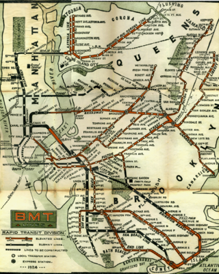
The BMT Lexington Avenue Line was the first standard elevated railway in Brooklyn, New York, operated in its later days by the Brooklyn Rapid Transit Company, the Brooklyn–Manhattan Transit Corporation, and then the City of New York.
Starting in 1899, the Brooklyn Rapid Transit Company and Brooklyn–Manhattan Transit Corporation operated rapid transit lines in New York City — at first only elevated railways and later also subways.

The Atlantic Avenue Railroad was a company in the U.S. state of New York, with a main line connecting downtown Brooklyn with Jamaica along Atlantic Avenue. It was largely a streetcar company that operated its own trains, but the Long Island Rail Road operated both streetcars and steam trains over its main line. It later became part of the Nassau Electric Railroad, but is now divided between the active Atlantic Branch of the LIRR and the unused Cobble Hill Tunnel, which is preserved in its original state, albeit without service tracks.

The B54 is a bus route on Myrtle Avenue in Brooklyn, New York City. The line travels between Downtown Brooklyn in the west and Myrtle–Wyckoff Avenues station in the east. The B54 operates from MTA New York City Bus's Fresh Pond Depot in Ridgewood, Queens. The route serves only the section of Myrtle Avenue within Brooklyn; the section within Queens is served by the Q55 bus.

The B41 is a bus route that constitutes a public transit line operating in Brooklyn, New York City, running along Flatbush Avenue between Downtown Brooklyn and Marine Park. The B41 is operated by the MTA New York City Transit Authority. Its precursor was a streetcar line that began operation in 1860, and was known as the Flatbush Avenue Line. The route became a bus line in 1951. Limited-stop service began along the route in 1992.

The DeKalb Avenue Line is a public transit line in Brooklyn and Queens, New York City, running mostly along DeKalb Avenue, as well as eastbound on Lafayette Avenue, between Downtown Brooklyn and Ridgewood, Queens. Originally a streetcar line, it is now the B38 DeKalb/Lafayette Avenues bus route, operated by the New York City Transit Authority.

The Bergen Street Line is a public transit line in Brooklyn, New York City, running westbound mostly along Bergen Street, as well as eastbound on Dean Street, between Downtown Brooklyn and Ocean Hill. Originally a streetcar line, it is now the B65 bus route, operated by the New York City Transit Authority. The B65 is based out of the East New York Depot in East New York, Brooklyn.
The Bushwick Avenue Line or Bushwick Line was a public transit line in Brooklyn, New York City, United States, running mostly along Bushwick Avenue and Myrtle Avenue between Williamsburg and Ridgewood, Queens.

The Nassau Electric Railroad was an electric street railway company in the U.S. state of New York. The company operated throughout the borough of Brooklyn, as well as over the Brooklyn Bridge and Williamsburg Bridge into Manhattan.
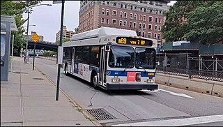
The B69 is a bus route that constitutes a public transit line operating in Brooklyn, New York City, running along 7th Avenue and Vanderbilt Avenue between Kensington and Dumbo. The B69 is operated by the MTA New York City Transit Authority. Its precursor was a streetcar line that began operation in 1869, and was known as the Vanderbilt Avenue Line. The route became a bus line in 1950.
The Brooklyn, Queens County and Suburban Railroad (BQC&S) was a street railway company in Brooklyn and Queens, New York, United States. It originated as a horsecar line until it was acquired by the Long Island Traction Company on November 24, 1893 and convert it into a subsidiary. The railroad was electrified in 1894.

The B45 is a bus route that constitutes a public transit line operating in Brooklyn, New York City, mainly along Atlantic Avenue, Washington Avenue, Sterling Place, and St. Johns Place between Downtown Brooklyn and Crown Heights. It is operated by the MTA New York City Transit Authority. Its precursor was a streetcar line that began operation in 1877, and was known as the St. Johns Place Line. The route became a bus line in 1947.

The Crosstown Line is a public transit line in Brooklyn, New York City, running along Van Brunt Street and Manhattan Avenue between Red Hook and Long Island City, Queens. Originally a streetcar line, it is now the B61 and the B62 bus routes. The northern section, the B62, is operated by MTA New York City Bus' Grand Avenue Depot in Maspeth, Queens, and the southern section is the B61, operated by MTA New York City Bus' Jackie Gleason Depot in Sunset Park. The entire route was a single line, the B61, until January 3, 2010; the B62 was previously a separate, parallel route between Downtown Brooklyn and Greenpoint, now part of the B43 route. The streetcar line, B61 and the original B62 previously operated from the now-closed Crosstown Depot in Greenpoint.
The Broadway Line was a public transit line in Brooklyn, New York City, United States along Broadway between Williamsburg and East New York. Originally a streetcar line, it later became a bus route, but no bus currently operates over the entire length of Broadway, with the BMT Jamaica Line above.
The Manhattan Beach Branch, Manhattan Beach Line, or Manhattan Beach Division was a line of the Long Island Rail Road, running from Fresh Pond, Queens, south to Manhattan Beach, Brooklyn, New York City, United States. It opened in 1877 and 1878 as the main line of the New York and Manhattan Beach Railway. The tracks from Flatbush south to Manhattan Beach were removed from 1938 to 1941, while most of the rest is now the freight-only Bay Ridge Branch.
The Long Island Traction Company was a street railway holding company in Brooklyn and Queens, New York City, United States.
The Union Avenue Line was a public transit line in Brooklyn, New York City, United States, running mostly along Myrtle Avenue, Knickerbocker Avenue, Flushing Avenue, Throop Avenue, and Union Avenue from Ridgewood, Queens northwest to Greenpoint, Brooklyn.
The Hicks Street Line was a public transit line in Brooklyn, New York City, United States, running from the Ninth Avenue Depot at Greenwood Cemetery to the Brooklyn Bridge.

From 1898 to 1950, various companies operated local trolley lines over the Brooklyn Bridge, taking passengers from many points in Brooklyn and Queens, New York City, United States to the Park Row terminal in Lower Manhattan. These lines entered the bridge roadway from Fulton Street or Sands Street in Downtown Brooklyn, some of them using elevated trackage at the Sands Street elevated railway station.

The West End Line or New Utrecht Avenue Line was a surface transit line in Brooklyn, New York City, United States, running along New Utrecht Avenue and other streets between Coney Island and Sunset Park. Built by the Brooklyn, Bath and Coney Island Railroad as a steam line, it became a trolley line, along which elevated trains ran until the new elevated BMT West End Line opened. This route is no longer part of any bus line; its southern part was part of a bus route. In 2013, the B64 route to Coney Island was restored.
References
- ↑ "More Railroad Accommodation". Brooklyn Daily Eagle . Brooklyn, NY. July 22, 1873. p. 4.
- ↑ "Boerum Place Railroad". Brooklyn Daily Eagle . Brooklyn, NY. August 11, 1873. p. 3.
- ↑ "Local Railroads - The New One". Brooklyn Daily Eagle . Brooklyn, NY. August 12, 1873. p. 2.
- ↑ "The Adams Street Railroad". Brooklyn Daily Eagle . Brooklyn, NY. November 24, 1873. p. 2.
- ↑ "The Railroad Corporations Fighting". Brooklyn Daily Eagle . Brooklyn, NY. May 12, 1874. p. 4.
- ↑ "Railroad Facilities". Brooklyn Daily Eagle . Brooklyn, NY. May 13, 1874. p. 4.
- ↑ Geo. W. Bromley & E. Robinson, Atlas of the Entire City of Brooklyn Complete in One Volume, 1880, plates 1 and 2
- ↑ "Protesting Property Owners". Brooklyn Daily Eagle . Brooklyn, NY. November 22, 1884. p. 2.
- ↑ Brooklyn Daily Eagle, In New Hands, February 2, 1885, page 4
- ↑ "South Brooklyn and the Bridge". Brooklyn Daily Eagle . Brooklyn, NY. December 14, 1885. p. 4.
- ↑ "Walks About the City". Brooklyn Daily Eagle . Brooklyn, NY. December 20, 1885. p. 10.
- ↑ "To Operate by the Trolley". Brooklyn Daily Eagle . Brooklyn, NY. July 8, 1893. p. 10.
- ↑ "Trolley Cars in Adams Street". Brooklyn Daily Eagle . Brooklyn, NY. July 10, 1893. p. 10.