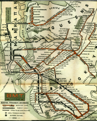
The BMT Brighton Line, also known as the Brighton Beach Line, is a rapid transit line in the B Division of the New York City Subway in Brooklyn, New York City, United States. Local service is provided at all times by the Q train, but is joined by the B express train on weekdays. The Q train runs the length of the entire line from Coney Island–Stillwell Avenue to the Manhattan Bridge south tracks. The B begins at Brighton Beach and runs via the bridge's north tracks.

The Brooklyn Rapid Transit Company (BRT) was a public transit holding company formed in 1896 to acquire and consolidate railway lines in Brooklyn and Queens, New York City, United States. It was a prominent corporation and industry leader using the single-letter symbol B on the New York Stock Exchange.
The BMT Jamaica Line, also known as the Broadway - Brooklyn Line is an elevated rapid transit line of the B Division of the New York City Subway, in Brooklyn and Queens, New York City, United States. It runs from the Williamsburg Bridge southeast over Broadway to East New York, Brooklyn, and then east over Fulton Street and Jamaica Avenue to Jamaica, Queens. In western Jamaica, the line goes into a tunnel, becoming the lower level of the Archer Avenue lines in central Jamaica. The J and Z trains serve the entire length of the Jamaica Line, and the M serves the line west of Myrtle Avenue.
The BMT Lexington Avenue Line was the first standard elevated railway in Brooklyn, New York, operated in its later days by the Brooklyn Rapid Transit Company, the Brooklyn–Manhattan Transit Corporation, and then the City of New York.
The Myrtle Avenue Line, also called the Myrtle Avenue Elevated, is a fully elevated line of the New York City Subway as part of the BMT division. The line is the last surviving remnant of one of the original Brooklyn elevated railroads. The remnant line operates as a spur branch from the Jamaica Line to Bushwick, Ridgewood, and Middle Village, terminating at its original eastern terminal across the street from Lutheran Cemetery. Until 1969, the line continued west into Downtown Brooklyn and, until 1944, over the Brooklyn Bridge to the Park Row Terminal in Manhattan.

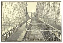
The Park Row station was a major elevated railway terminal constructed on the Manhattan side of the Brooklyn Bridge, across from New York City Hall and the IRT’s elevated City Hall station. It served as the terminal for BMT services operating over the Brooklyn Bridge Elevated Line from the BMT Fulton Street Line, BMT Myrtle Avenue Line and their feeders. Until the opening of the nearby Williamsburg Bridge to elevated train traffic in 1913, it was the only Manhattan station available for elevated trains from Brooklyn, and the only elevated station in Manhattan to be owned by a company other than the IRT or its predecessors.

The BMT Franklin Avenue Line is a rapid transit line of the New York City Subway in Brooklyn, New York, running between Franklin Avenue and Prospect Park. Service is full-time, and provided by the Franklin Avenue Shuttle. The line serves the neighborhoods of Bedford-Stuyvesant and Crown Heights, and allows for easy connections between the Fulton Street Line and the Brighton Line.
Starting in 1899, the Brooklyn Rapid Transit Company and Brooklyn–Manhattan Transit Corporation operated rapid transit lines in New York City — at first only elevated railways and later also subways.
The Kings County Elevated Railway Company (KCERy) was a builder and operator of elevated railway lines in Kings County, New York. Kings County is now coextensive with the borough of Brooklyn in New York City, but at the time the railway started, it consisted of several towns and the smaller independent city of Brooklyn. Its original services were operated with steam locomotives.
The Culver Line, Gravesend Avenue Line, or McDonald Avenue Line was a surface public transit line in Brooklyn, New York City, United States, running along McDonald Avenue and built by the Prospect Park and Coney Island Railroad. Most of its main line has been essentially replaced by the IND Culver Line of the New York City Subway.

The B54 is a bus route on Myrtle Avenue in Brooklyn, New York City. The line travels between Downtown Brooklyn in the west and Myrtle–Wyckoff Avenues station in the east. The B54 operates from MTA New York City Bus's Fresh Pond Depot in Ridgewood, Queens. The route serves only the section of Myrtle Avenue within Brooklyn; the section within Queens is served by the Q55 bus.

The DeKalb Avenue Line is a public transit line in Brooklyn and Queens, New York City, running mostly along DeKalb Avenue, as well as eastbound on Lafayette Avenue, between Downtown Brooklyn and Ridgewood, Queens. Originally a streetcar line, it is now the B38 DeKalb/Lafayette Avenues bus route, operated by the New York City Transit Authority.
The Brooklyn Heights Railroad was a street railway company in the U.S. state of New York. It leased and operated the streetcar lines of the Brooklyn Rapid Transit Company, but started out with the Montague Street Line, a short cable car line connecting the Wall Street Ferry with downtown Brooklyn along Montague Street. Eliphalet Williams Bliss owned the railroad.

The Nassau Electric Railroad was an electric street railway company in the U.S. state of New York. The company operated throughout the borough of Brooklyn, as well as over the Brooklyn Bridge and Williamsburg Bridge into Manhattan.
The B69 is a bus route that constitutes a public transit line operating in Brooklyn, New York City, running along 7th Avenue and Vanderbilt Avenue between Kensington and Dumbo. The B69 is operated by the MTA New York City Transit Authority. Its precursor was a streetcar line that began operation in 1869, and was known as the Vanderbilt Avenue Line. The route became a bus line in 1950.

The Fifth Avenue Line, also called the Fifth Avenue Elevated or Fifth Avenue–Bay Ridge Line, was an elevated rail line in Brooklyn, New York City, United States. It ran above Hudson Avenue, Flatbush Avenue, Fifth Avenue, 38th Street, and Third Avenue from Downtown Brooklyn south to Bay Ridge. The portion on Third Avenue was called the Third Avenue Elevated to distinguish service from the elevated BMT West End Line; it was separate from the elevated IRT Third Avenue Line in Manhattan and the Bronx.
The Adams Street and Boerum Place Line was a public transit line in Downtown Brooklyn, New York City, United States, running along Boerum Place and Adams Street. It served as access for the Atlantic Avenue Railroad to the City Hall area.

The West End Line or New Utrecht Avenue Line was a surface transit line in Brooklyn, New York City, United States, running along New Utrecht Avenue and other streets between Coney Island and Sunset Park. Built by the Brooklyn, Bath and Coney Island Railroad as a steam line, it became a trolley line, along which elevated trains ran until the new elevated BMT West End Line opened. This route is no longer part of any bus line; its southern part was part of a bus route. In 2013, the B64 route to Coney Island was restored.

The Williamsburg Bridge Trolley Terminal, also called the Essex Street Trolley Terminal or Delancey Street Trolley Terminal, was a trolley terminal located underground adjacent to the Essex Street subway station in the Lower East Side of Manhattan. Passenger trolley service operated through the terminal from 1908 until 1948 when trolley service over the Williamsburg Bridge ended. The station was constructed with balloon loops for turning around streetcars after they crossed over the Williamsburg Bridge to send them back to Brooklyn.