
Lisnaskea is the second-biggest settlement in County Fermanagh, Northern Ireland. It is situated mainly in the townland of Lisoneill, with some areas in the townland of Castle Balfour Demesne, both in the civil parish of Aghalurcher and the historic barony of Magherastephana. It had a population of 2,960 people at the 2011 Census.
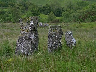
Drumskinny is the site of a stone circle in the townland of Drumskinny, County Fermanagh, Northern Ireland. With the inclusion of an adjacent cairn and alignment, the stone circle is a State Care Historic Monument in Fermanagh and Omagh district, at grid ref: H 2009 7072. The site was excavated in 1962 and is believed to have built around 2000 BC.
A townland is a small geographical division of land used in Ireland and in the Western Isles in Scotland. The townland system is of Gaelic origin, pre-dating the Norman invasion, and most have names of Irish origin. However, some townland names and boundaries come from Norman manors, plantation divisions, or later creations of the Ordnance Survey. The total number of inhabited townlands in Ireland was 60,679 in 1911. The total number recognised by the Irish Place Names database as of 2014 was 61,098, including uninhabited townlands, mainly small islands.

Beragh is a village and townland in County Tyrone, Northern Ireland. It is about 8 miles Southeast of Omagh and is in the Fermanagh and Omagh District Council area. The 2001 Census recorded a population of 520.

Ederney is a village situated primarily in the townlands of Drumkeen and of Ederny in County Fermanagh, Northern Ireland.

Ballycassidy is a small village and townland in County Fermanagh, Northern Ireland, 6.5 km north of Enniskillen on the eastern shore of Lower Lough Erne. It is situated in the civil parish of Trory and the historic barony of Tirkennedy. In the 2001 Census it had a population of 315 people. It is situated within Fermanagh and Omagh district.

Laragh is a townland of 132 acres in County Fermanagh, Northern Ireland. It is situated in the civil parish of Trory and the historic barony of Tirkennedy. It is near Enniskillen Airport.
Trory is a townland, small village and civil parish in County Fermanagh, Northern Ireland, 3 miles (5 km) north of Enniskillen. The townland is situated in the historic barony of Tirkennedy, but the civil parish covers areas of the barony of Tirkennedy, as well as the barony of Lurg. In the 2001 Census it had a population of 315 people. It lies within the Fermanagh and Omagh District Council area.

Kinawley or Kinawly is a small village, townland and civil parish straddling County Fermanagh, Northern Ireland and County Cavan Republic of Ireland. The village and townland are both in the civil parish of Kinawley in the historic barony of Clanawley, while other areas of the parish are in the baronies of Knockninny in County Fermanagh and Tullyhaw in County Cavan. In the 2011 Census it had a population of 141 people.

Lack is a small village and townland in County Fermanagh, Northern Ireland, 5.5 km east-north-east of Ederny. It is situated in the civil parish of Magheraculmoney and the historic barony of Lurg. It had a population of 111 people in the 2011 Census..
Tamlaght is a townland and village in County Fermanagh, Northern Ireland, 4.5 km south-east of Enniskillen. It is situated in the civil parish of Derryvullan and the historic barony of Tirkennedy. In the 2001 Census it had a population of 276 people.

Aghalurcher is a civil parish located mainly in the barony of Magherastephana in County Fermanagh and partly in the barony of Clogher in County Tyrone, Northern Ireland.

Moylehid is a townland in County Fermanagh, Northern Ireland. It is in the civil parish of Boho. This townland has also been variously known as Moylehide (1609), Moolet (1659), Moylehit, Mullyleet, Mul Leathaid and Mul-leithid (1834).

Magheracross is a townland and civil parish in County Fermanagh, Northern Ireland. It extends in area from just north of Enniskillen to the Border with County Tyrone. There is also a small enclave in County Tyrone.
Tattykeeran is a townland of 459 acres in County Fermanagh, Northern Ireland. It is situated in the civil parish of Aghavea and the historic barony of Magherastephana.
Knocks is a townland to the east of Lisnaskea in County Fermanagh, Northern Ireland. It is situated in the historic barony of Magherastephana and the civil parish of Aghalurcher and covers an area of 193 acres.

Castle Balfour Demesne is a townland of 201 acres in County Fermanagh, Northern Ireland. It is situated in the civil parish of Aghalurcher and the historic barony of Magherastephana. It contains part of the small town of Lisnaskea, with the remainder in the townland of Lisoneill.
Derrybrusk is a civil parish and townland in County Fermanagh, Northern Ireland. The civil parish is mainly situated in the historic barony of Tirkennedy with a small portion in the barony of Magherastephana. Derrybrusk townland is in the portion of the parish of the same name in Tirkennedy.
Derryvullan is a civil parish and townland in County Fermanagh, Northern Ireland. The civil parish is situated in the historic baronies of Tirkennedy and Lurg. Derryvullan townland is in the portion of the parish of the same name in Tirkennedy.


