Coordinates: 40°57′42″N49°09′45″E / 40.96167°N 49.16250°E
A geographic coordinate system is a coordinate system that enables every location on Earth to be specified by a set of numbers, letters or symbols. The coordinates are often chosen such that one of the numbers represents a vertical position and two or three of the numbers represent a horizontal position; alternatively, a geographic position may be expressed in a combined three-dimensional Cartesian vector. A common choice of coordinates is latitude, longitude and elevation. To specify a location on a plane requires a map projection.
Agsiazan | |
---|---|
Coordinates: 40°57′42″N49°09′45″E / 40.96167°N 49.16250°E | |
Country | |
Rayon | Khizi |
Time zone | AZT (UTC+4) |
• Summer (DST) | AZT (UTC+5) |
Agsiazan (also, Agsiazan’ and Agsiyazan’) is a village in the Khizi Rayon of Azerbaijan.
A village is a clustered human settlement or community, larger than a hamlet but smaller than a town, with a population ranging from a few hundred to a few thousand. Though villages are often located in rural areas, the term urban village is also applied to certain urban neighborhoods. Villages are normally permanent, with fixed dwellings; however, transient villages can occur. Further, the dwellings of a village are fairly close to one another, not scattered broadly over the landscape, as a dispersed settlement.
Azerbaijan, officially the Republic of Azerbaijan, is a country in the South Caucasus region of Eurasia at the crossroads of Eastern Europe and Western Asia. It is bounded by the Caspian Sea to the east, Russia to the north, Georgia to the northwest, Armenia to the west and Iran to the south. The exclave of Nakhchivan is bounded by Armenia to the north and east, Iran to the south and west, and has an 11 km long border with Turkey in the northwest.
Neudorf-Weimershof is a quarter in eastern Luxembourg City, in southern Luxembourg.
Pillco Marca District is one of twelve districts of the province Huánuco in Peru.
Yeghegnut, is a village in the Armavir Province of Armenia. The majority of the village are Armenians (70%) with 663 of the Yazidi minority.
Avgerinos is a community located in the Tsotyli municipal unit, situated in western Kozani regional unit, in the Greek region of Macedonia.
Neraida is a village located along the Aliakmon River in Servia municipal unit, Kozani regional unit, in the Greek region of Macedonia. It is situated at an altitude of 280 meters. The postal code is 50100, while the telephone code is +30 24640. At the 2011 census the population was 148.
Zawady-Kolonia is a village in the administrative district of Gmina Zawady, within Białystok County, Podlaskie Voivodeship, in north-eastern Poland.
Zagróbki is a village in the administrative district of Gmina Daszyna, within Łęczyca County, Łódź Voivodeship, in central Poland. It lies approximately 6 kilometres (4 mi) west of Daszyna, 15 km (9 mi) north-west of Łęczyca, and 49 km (30 mi) north-west of the regional capital Łódź.
Helenów is a village in the administrative district of Gmina Budziszewice, within Tomaszów Mazowiecki County, Łódź Voivodeship, in central Poland. It lies approximately 3 kilometres (2 mi) north-east of Budziszewice, 19 km (12 mi) north of Tomaszów Mazowiecki, and 36 km (22 mi) east of the regional capital Łódź.
Zawada is a village in the administrative district of Gmina Myślenice, within Myślenice County, Lesser Poland Voivodeship, in southern Poland. It lies approximately 6 kilometres (4 mi) north-east of Myślenice and 21 km (13 mi) south of the regional capital Kraków.
Kazimierzów is a village in the administrative district of Gmina Stoczek, within Węgrów County, Masovian Voivodeship, in east-central Poland. It lies approximately 11 kilometres (7 mi) north of Węgrów and 73 km (45 mi) north-east of Warsaw.
Drzązgowo is a village in the administrative district of Gmina Chodzież, within Chodzież County, Greater Poland Voivodeship, in west-central Poland. It lies approximately 6 kilometres (4 mi) south-west of Chodzież and 63 km (39 mi) north of the regional capital Poznań.
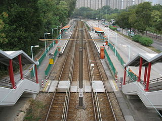
Butterfly is an MTR Light Rail stop. It is located at ground level at Lung Mun Road, near Butterfly Estate and Siu Shan Court, in Tuen Mun District. It began service on 18 September 1988 and belongs to Zone 1.
Podolanka is a village and municipality in Prague-East District in the Central Bohemian Region of the Czech Republic.
Wuhu County is a county in the southeast of Anhui Province, China. It is under the administration of Wuhu City.
The Buzău Power Station is a large thermal power plant located in Buzău, having 4 generation groups of 45 MW and one group of 27 MW and having a total electricity generation capacity of 207 MW.
Grabež is a village in the municipality of Bihać, Bosnia and Herzegovina.
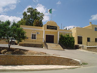
Bouaichoune is a town and commune in Médéa Province, Algeria. According to the 1998 census it has a population of 4036.
Massu is a village in Põhja-Pärnumaa Parish, Pärnu County in western-central Estonia.
Blatné is a lake in Slovakia. It covers an area of 1.55 hectares.
The Church of the Holy Archangels, is a church located in the town of Vagharshapat, Armenia, within the complex of the Mother See of Holy Etchmiadzin, adjacent to the Gevorkian Theological Seminary.
This Khizi Rayon location article is a stub. You can help Wikipedia by expanding it. |