
The Arctic Archipelago, also known as the Canadian Arctic Archipelago, is a group of islands north of the Canadian mainland.

Valentovce is a small village and municipality in the Medzilaborce District in the Prešov Region of far north-eastern Slovakia.
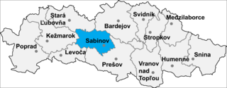
Dubovica is a village and municipality in Sabinov District in the Prešov Region of north-eastern Slovakia.
Congdü is a township in Nyalam County, the Tibet Autonomous Region of China. It lies at an altitude of 3,763 metres. The village has a population of about 237.
Rindü is a village and township in the Tibet Autonomous Region of China.
Balia, Bangladesh may refer to the following locations in Bangladesh:

Hovtun is a village in the Shirak Province of Armenia.

Rostołty is a village in the administrative district of Gmina Juchnowiec Kościelny, within Białystok County, Podlaskie Voivodeship, in north-eastern Poland. It lies approximately 6 kilometres (4 mi) south of Juchnowiec Kościelny and 17 km (11 mi) south of the regional capital Białystok.
Mikołajki is a village in the administrative district of Gmina Łomża, within Łomża County, Podlaskie Voivodeship, in north-eastern Poland. It lies approximately 9 kilometres (6 mi) south-west of Łomża and 81 km (50 mi) west of the regional capital Białystok.
Duńkowice is a village in the administrative district of Gmina Radymno, within Jarosław County, Subcarpathian Voivodeship, in south-eastern Poland, close to the border with Ukraine. It lies approximately 7 kilometres (4 mi) east of Radymno, 17 km (11 mi) east of Jarosław, and 65 km (40 mi) east of the regional capital Rzeszów.
Pirəkəşkül-Qobustan is a municipality in the Absheron Rayon of Azerbaijan. It has a population of 1,967. The municipality consists of the villages of Pirəkəşkül and Qobustan.
Cẩm Giàng is a rural commune (xã) and village in Bạch Thông District, Bắc Kạn Province, in Vietnam.
Gazantarak is a town and jamoat in north-west Tajikistan. It is located in Ghonchi District in Sughd province. The jamoat has a total population of 13,359.

Kořenice is a village and municipality in Kolín District in the Central Bohemian Region of the Czech Republic.
Kotly is the name of several rural localities in Russia.
Mường Tùng is a commune (xã) and village of the Mường Chà District of Điện Biên Province, northwestern Vietnam.
Dekanmè is a town and arrondissement in the Atlantique Department of southern Benin. It is an administrative division under the jurisdiction of the commune of Kpomassè. According to the population census conducted by the Institut National de la Statistique Benin on February 15, 2002, the arrondissement had a total population of 8,581.
Gouka is a town and arrondissement in the Collines Department of Benin. It is an administrative division under the jurisdiction of the commune of Bantè. According to the population census conducted by the Institut National de la Statistique Benin back in 2006, the arrondissement had a total population of 16.070.
Tanvé is an arrondissement in the Zou department of Benin. It is an administrative division under the jurisdiction of the commune of Agbangnizoun. According to the population census conducted by the Institut National de la Statistique Benin on February 15, 2002, the arrondissement had a total population of 8,034.


