Lipperscheid is a village in the commune of Bourscheid, in north-eastern Luxembourg. As of July 2007, the village had a population of 190.

Hrkovce is a village and municipality in the Levice District in the Nitra Region of Slovakia. The mayor is Gejza Nagy.
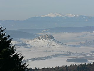
Branisko is a mountain range in eastern Slovakia, between the Spiš and Šariš regions. It is a 20 km long and 5 km wide mountain range in the north-south direction, belonging to the Fatra-Tatra Area of the Inner Western Carpathians.

Prey Kabbas District is a district located in Takéo Province, in southern Cambodia. According to the 1998 census of Cambodia, it had a population of 85,880.
An Nhơn is a district-level town of Bình Định Province in the South Central Coast region of Vietnam. As of 2003 the district had a population of 187,737. The district covers an area of 255 km². The district capital is Bình Định. It has a population density of 779 people per km2, and they are distributed unevenly, with high concentrations in the wards of Bình Định and Đập Đá. 55.50% of the population in the district are of working age.
Thống Nhất is a rural district of Đồng Nai Province in the Southeast region of Vietnam. As of 2003, the district had a population of 146,112. The district covers an area of 247 km². The district capital lies at Gia Kiệm.

Quản Bạ is a rural district of Ha Giang province in the Northeast region of Vietnam. As of 2003, the district had a population of 39,821. The district covers an area of 550 km². The district capital lies at Tam Sơn.
Tam Bình is a rural district of Vĩnh Long Province, in the Mekong Delta region of Vietnam. As of 2003, the district had a population of. The district covers an area of 280 km². The district capital lies at Tam Bình.

Batken is a raion (district) of Batken Region in south-western Kyrgyzstan. Its area is 5,948 square kilometres (2,297 sq mi), and its resident population was 69,591 in 2009. The capital lies at Batken.
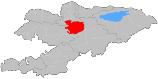
Jumgal is a raion (district) of Naryn Region in central Kyrgyzstan. The capital lies at Chaek. Its area is 4,803 square kilometres (1,854 sq mi), and its resident population was 40,718 in 2009. The river Jumgal is situated in this district, it is a tributary of Kökömeren River, the latter is tributary to Naryn river.

Kara-Kulja is a raion (district) of Osh Region in south-western Kyrgyzstan. Its area is 5,813 square kilometres (2,244 sq mi), and its resident population was 87,691 in 2009. The capital lies at Kara-Kulja.

Uzgen or Özgön is a raion (district) of Osh Region in south-western Kyrgyzstan. Its area is 3,308 square kilometres (1,277 sq mi), and its resident population was 228,114 in 2009. The capital lies at Uzgen.

Frydek is a village in the administrative district of Gmina Miedźna, within Pszczyna County, Silesian Voivodeship, in southern Poland. It lies approximately 13 kilometres (8 mi) south-east of Pszczyna and 38 km (24 mi) south of the regional capital Katowice.

Kyzylly is a village in the Davachi Rayon of Azerbaijan.
Gariban is a village in the Khizi Rayon of Azerbaijan.
Pawlikowice is a village in the administrative district of Gmina Wieliczka, within Wieliczka County, Lesser Poland Voivodeship, in southern Poland. It lies approximately 9 kilometres (6 mi) south of Wieliczka and 20 km (12 mi) south-east of the regional capital Kraków.

Nowa Cerekwia is a village in the administrative district of Gmina Kietrz, within Głubczyce County, Opole Voivodeship, in south-western Poland, close to the Czech border. It lies approximately 7 kilometres (4 mi) west of Kietrz, 15 km (9 mi) south-east of Głubczyce, and 65 km (40 mi) south of the regional capital Opole.
Kastel (village) is a village in the municipality of Sevlievo, in Gabrovo Province, in northern central Bulgaria.
Bhadva(भाडवा) is a village in Kotda-Sangni Taluka of Rajkot district, Gujarat, India. It is situated fifteen miles south-east of Rajkot and about thirteen miles north-east of Gondal.


