
Dickinson Township is a township in Cumberland County, Pennsylvania, United States. The population was 5,223 at the 2010 census, up from 4,702 at the 2000 census.

Kęty is a town in Oświęcim County, Lesser Poland Voivodeship, Poland with 18,955 inhabitants (2012). The town located in Silesian Foothills dates its earliest document from 1277 when Polish prince of Opole Władysław confirmed sale of the settlement and adoption of Lviv city rights. The town's name comes from the word kąt. The greatest development of the town came under the rule of Jagiellons, when the town became royal property.

Lyakhavichy District is an administrative subdivision, a raion of Brest Region, in Belarus.
Wolica is a village in Poland located in Lesser Poland Voivodeship, in Bochnia County, in Gmina Łapanów. It had a population of 230 in 2005. It lies approximately 3 kilometres (2 mi) west of Łapanów, 19 km (12 mi) south-west of Bochnia, and 33 km (21 mi) south-east of the regional capital Kraków.
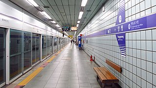
Yangpyeong Station is Line 5 subway station in Seoul, South Korea. The station lies near Yeouido and lots of apartment complexes are there. In fact, the confirmation was allowed to rebuild old complex.
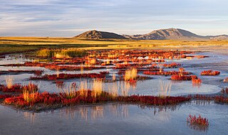
Uvs Lake Basin is an endorheic basin located on the territorial border of Mongolia and Tuva, a republic of the Russian Federation. The basin is part of the Central Asian Internal Drainage Basin and is named after Uvs Lake, a large saline lake situated in the western part of its drainage basin. Uvs Lake is a shallow lake with an area of 3,350 km2 (1,290 sq mi). Its entire basin, which includes several smaller lakes, is 70,000 km2 (27,000 sq mi).
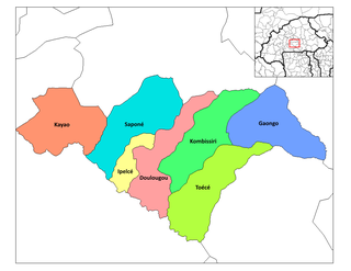
Toece is a department or commune of Bazèga Province in central Burkina Faso. Its capital lies at the town of Toece. According to the 1996 census the department has a total population of 33,608.

Artimet is a village in the Armavir Province of Armenia. The church of the village named after Saint Gregory the Illuminator, dates back to 1876.
Kąciki is a village in the administrative district of Gmina Jedwabne, within Łomża County, Podlaskie Voivodeship, in north-eastern Poland.

Kechalmamedli is a village in the Jabrayil Rayon of Azerbaijan.
Sığırlı is a village and municipality in the Kurdamir Rayon of Azerbaijan.
Grand Prairie Township is a civil township in Barnes County, North Dakota, USA. As of the 2000 census, its population was 49.
Glitajny is a village in the administrative district of Gmina Bartoszyce, within Bartoszyce County, Warmian-Masurian Voivodeship, in northern Poland, close to the border with the Kaliningrad Oblast of Russia.
Lipník is a village and municipality in Mladá Boleslav District in the Central Bohemian Region of the Czech Republic.

Metsanurme is a village in Saku Parish, Harju County in northern Estonia.

Heer Land is a land area on the east coast of Spitsbergen, Svalbard. It is bordered by Rindersbukta to the southwest, Braganzavågen and Kjellströmdalen to the northwest, Storfjorden to the east and southeast, and Torell Land to the south. It is named after paleobotanist Oswald Heer. Heer Land mainly consist of glaciers and nunataks.
Brock is an unincorporated community in Darke County, in the U.S. state of Ohio.
Park is an extinct town in Whatcom County, in the U.S. state of Washington.

Kzyloba is a town in Atyrau Region, west Kazakhstan. It lies at an altitude of 10 m (33 ft) below sea level.


