
Prienai District Municipality is one of 60 municipalities in Lithuania.

Hoštice is a village in Strakonice District, South Bohemian Region, Czech Republic. It has a population of 171. Filmmaker Zdeněk Troška and singer Michal Tučný were born here.

Krasków is a village in the administrative district of Gmina Marcinowice, within Świdnica County, Lower Silesian Voivodeship, in south-western Poland. Prior to 1945 it was in Germany.
Kułakowice Trzecie is a village in the administrative district of Gmina Hrubieszów, within Hrubieszów County, Lublin Voivodeship, in eastern Poland, close to the border with Ukraine. It lies approximately 13 kilometres (8 mi) north-west of Hrubieszów and 94 km (58 mi) south-east of the regional capital Lublin.
Dąbrowa is a village in the administrative district of Gmina Jeżów, within Brzeziny County, Łódź Voivodeship, in central Poland.
Świerczów is a village in the administrative district of Gmina Widawa, within Łask County, Łódź Voivodeship, in central Poland. It lies approximately 3 kilometres (2 mi) north-west of Widawa, 22 km (14 mi) south-west of Łask, and 53 km (33 mi) south-west of the regional capital Łódź.

Khalafli is a village in the Jabrayil Rayon of Azerbaijan.
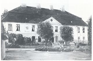
Maluszyn is a village in the administrative district of Gmina Żytno, within Radomsko County, Łódź Voivodeship, in central Poland. It lies approximately 12 kilometres (7 mi) east of Żytno, 30 km (19 mi) south-east of Radomsko, and 100 km (62 mi) south of the regional capital Łódź.
Chruściechów is a village in the administrative district of Gmina Stara Błotnica, within Białobrzegi County, Masovian Voivodeship, in east-central Poland. It lies approximately 8 kilometres (5 mi) south of Białobrzegi and 71 km (44 mi) south of Warsaw.
Kinno is a village in the administrative district of Gmina Orchowo, within Słupca County, Greater Poland Voivodeship, in west-central Poland.
Barlewiczki is a village in the administrative district of Gmina Sztum, within Sztum County, Pomeranian Voivodeship, in northern Poland. It lies approximately 2 kilometres (1 mi) south-east of Sztum and 58 km (36 mi) south-east of the regional capital Gdańsk.
Barcino is a village in the administrative district of Gmina Kępice, within Słupsk County, Pomeranian Voivodeship, in northern Poland. It lies approximately 7 kilometres (4 mi) north-east of Kępice, 22 km (14 mi) south of Słupsk, and 110 km (68 mi) west of the regional capital Gdańsk.
Marcinkowo is a village in the administrative district of Gmina Braniewo, within Braniewo County, Warmian-Masurian Voivodeship, in northern Poland, close to the border with the Kaliningrad Oblast of Russia. It lies approximately 10 kilometres (6 mi) south-east of Braniewo and 71 km (44 mi) north-west of the regional capital Olsztyn.
Ławki is a village in the administrative district of Gmina Ryn, within Giżycko County, Warmian-Masurian Voivodeship, in northern Poland. It lies approximately 4 kilometres (2 mi) south-east of Ryn, 19 km (12 mi) south-west of Giżycko, and 73 km (45 mi) east of the regional capital Olsztyn.
Trzebień is a village in the administrative district of Gmina Bobolice, within Koszalin County, West Pomeranian Voivodeship, in north-western Poland. It lies approximately 7 kilometres (4 mi) east of Bobolice, 42 km (26 mi) south-east of Koszalin, and 152 km (94 mi) north-east of the regional capital Szczecin.

Bình Giã is a commune (xã) and village in Châu Đức District, Bà Rịa–Vũng Tàu Province, in Vietnam.

Vraneši is a village in the municipality of Sokolac, Bosnia and Herzegovina.
Eerikulaid is an island belonging to the country of Estonia.
Esenyaka is a village in the District of Yusufeli, Artvin Province, Turkey. As of 2010 it had a population of 286 people.
Zelenyi Hai is a village in Antratsyt Raion, Luhansk Oblast, Ukraine.


