Al-Chibayish

Last updated
Al-Chibayish
الجبايش
hwr l`rq . ljbysh 15.jpg
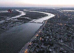
Al-Chibayish from the air
Nickname: 
City of the Marshes
Iraq adm location map.svg
Red pog.svg
Al-Chibayish
Coordinates: 30°57′17.7″N46°58′30.3″E / 30.954917°N 46.975083°E / 30.954917; 46.975083
CountryFlag of Iraq.svg  Iraq
Governorate Dhi Qar
District Al-Chibayish
Elevation
9 m (30 ft)
Population
 (2014)
  Total36,100 [1]
Time zone UTC+3 (AST)
Area code 01

Al-Chibayish is a town on the Euphrates River in Al-Chibayish District, Dhi Qar governorate, in southern Iraq. It is the capital of its eponymous district.

Contents

Al-Chibayish is inhabited primarily by Marsh Arabs of the Beni Isad tribe. Al-Chibayish has historically been an important hub for the Marsh Arab people and a traditional boat-building center for their mashoof canoes. [2]

History

Al-Chibayish was historically home to a community of Mandaeans, as well as Arabs. In 1895, Sheikh Ṣaḥan ibn Sheikh Ṣagar (Ṣaqar in standard Arabic), a Mandaean priest, was arrested near Chabāyish in Iraq and imprisoned in Basra. He was accused of supporting an Arab tribal rebellion led by Jāsim al-Khayyūn (of the Bani Asad tribe, one of the largest tribes affiliated with the Al-Muntafiq), as well as killing his nephew. Although a petition was delivered to the British authorities to have him released, and the British attempted to assist Sheikh Sahan, he was not released and died in prison in 1898. [3]

Al-Chibayish was the subject of a groundbreaking 1955 ethnographic study, Marsh Dwellers of the Euphrates Delta, by Iraqi anthropologist Shakir Mustafa Salim. [4]

Al-Chibayish was home to about 11,000 people in 1955. [4] Al-Chibayish's population dropped to less than 6,000 by 2003 as a result of Saddam Hussein's draining of the Mesopotamian Marshes and his associated campaign of violence against the Marsh Arabs, during which Al-Chibayish was attacked by military helicopters. [5] However, the population recovered and quintupled between 2001 and 2009, when it reached an estimated 30,416 people. [1]

Related Research Articles

<span class="mw-page-title-main">Baghdad</span> Capital and largest city of Iraq

Baghdad is the capital of Iraq and the second-largest city in the Arab world after Cairo. It is located on the Tigris river. In 762 AD, Baghdad was founded as the capital of the Abbasid Caliphate, and became its most notable major development project. Within a short time, the city evolved into a significant cultural, commercial, and intellectual center of the Muslim world. This, in addition to housing several key academic institutions, including the House of Wisdom, as well as a multi-ethnic and multi-religious environment, garnered it a worldwide reputation as the "Center of Learning".

<span class="mw-page-title-main">Tigris</span> River in Turkey, Iraq, and Syria

The Tigris is the eastern of the two great rivers that define Mesopotamia, the other being the Euphrates. The river flows south from the mountains of the Armenian Highlands through the Syrian and Arabian Deserts, before merging with the Euphrates and reaching to the Persian Gulf.

<span class="mw-page-title-main">Basra</span> Metropolis in Iraq

Basra is a city in southern Iraq. It is the capital and largest city of the eponymous Basra Governorate, as well as the third largest city in Iraq overall, behind only Baghdad and Mosul. Basra is located near the Iran–Iraq border at the northeasternmost extent of the Arabian Peninsula, situated along the banks of the Shatt al-Arab that empties into the Persian Gulf. The majority of the city's population are Shia Muslim Arabs. Basra is consistently one of the hottest cities in Iraq, with summer temperatures regularly exceeding 50 °C (122 °F). The hottest recorded temperature in Basra is 53.9 °C.

<span class="mw-page-title-main">Dhi Qar Governorate</span> Governorate of Iraq

Dhi Qar Governorate is a governorate in southern Iraq, in the Arabian Peninsula. The provincial capital is Nasiriyah. Prior to 1976 the governorate was known as Muntafiq Governorate. Thi Qar was the heartland of the ancient Iraqi civilization of Sumer, and includes the ruins of Ur, Eridu, Lagash, Larsa, Girsu, Umma, and Bad-tibira. The southern area of the governorate is covered by Mesopotamian Marshes.

<span class="mw-page-title-main">Marsh Arabs</span> Indigenous people of southern Iraq

The Marsh Arabs, also referred to as Ahwaris, the Maʻdān or Shroog —the latter two often considered derogatory in the present day—are Arab inhabitants of the Mesopotamian marshlands in the modern-day south Iraq, as well as in the Hawizeh Marshes straddling the Iraq-Iran border.

<span class="mw-page-title-main">Al Anbar Governorate</span> Governorate of Iraq

Al Anbar Governorate, or Anbar Province, is the largest governorate in Iraq by area. Encompassing much of the country's western territory, it shares borders with Syria, Jordan, and Saudi Arabia. The population is mostly Sunni Arabs. The provincial capital is Ramadi; other important cities include Fallujah, Al-Qa'im and Haditha.

Iranian Arabs are the citizens of Iran who are ethnically Arab and speak Arabic as their native language. In 2008, their population stood at about 1.6 million people. They are primarily concentrated in Khuzestan Province.

<span class="mw-page-title-main">Iraqi Revolt</span> Conflict

The Iraqi Revolt began in Baghdad in the summer of 1920 with mass demonstrations by Iraqis, including protests by embittered officers from the old Ottoman Army, against the British who published the new land ownership and the burial taxes at Najaf. The revolt gained momentum when it spread to the largely tribal Shia regions of the middle and lower Euphrates. Sheikh Mehdi Al-Khalissi was a prominent Shia leader of the revolt. Using heavy artillery and aerial bombardment, the uprising was suppressed by the British.

Minorities in Iraq include various ethnic and religious groups.

<span class="mw-page-title-main">Iraqis</span> Citizens or residents of Iraq

Iraqis are people who originate from the country of Iraq.

<span class="mw-page-title-main">Karkh</span> Historical region in Baghdad, Iraq

Al-Karkh or just Karkh is historically the name of the western half of Baghdad, Iraq, or alternatively, the western shore of the Tigris River as it ran through Baghdad. The eastern shore is known as al-Rusafa. Historically, al-Karkh has been a commerce market during the Abbasid Caliphate, located outside the main Round City due to safety concerns. It saw many exports and was the main business place for merchants and craftsmen. Al-Karkh has also historically suffered from infighting, fire, and floods that impacted its population and topography.

<span class="mw-page-title-main">Mesopotamian Marshes</span> Wetlands in Iraq, Iran and Kuwait

The Mesopotamian Marshes, also known as the Iraqi Marshes, are a wetland area located in Southern Iraq and southwestern Iran as well as partially in northern Kuwait. The marshes are primarily located on the floodplains of the Euphrates and Tigris rivers bound by the cities of Basra, Nasiriyah, Amarah and a portion of southwestern Iran and northern Kuwait. Historically the marshlands, mainly composed of the separate but adjacent Central, Hawizeh and Hammar Marshes, used to be the largest wetland ecosystem of Western Eurasia. The unique wetland landscape is home to the Marsh people, who have developed a unique culture tightly coupled to the landscape – harvesting reeds and rice, fishing and herding water buffalo.

Dulaim or Dulaimi or Al Duliam or Dulaym is an Arab royal tribe, with over seven million members. The tribe's history goes back to pre-Islamic times and members reside today in Iraq and neighboring countries such as Syria, Kuwait and Jordan.

<span class="mw-page-title-main">Hawizeh Marshes</span> Marshes in Iran and Iraq; UNESCO World Heritage site

The Hawizeh Marshes are a complex of marshes that straddle the Iran–Iraq border. The marshes are fed by two branches of the Tigris River in Iraq and the Karkheh River in Iran. The Hawizeh marsh is critical to the survival of the Central and Hammar marshes also make up the Mesopotamian Marshes, because they are a refuge for species that may recolonize or reproduce in other marshlands. Hawizeh Marshes are drained by the Al-Kassarah. This river plays a critical role in maintaining the marshes as a flow-through system and preventing it from becoming a closed saline basin.

<span class="mw-page-title-main">Al-Chibayish District</span> District in Dhi Qar Governorate, Iraq

Al-Chibayish District is a district of the Dhi Qar Governorate, Iraq, located to the east of Nasiriyah and northwest of Basra Governorate. The district capital is Al-Chibayish. The district's geography is dominated by the Hammar Marshes, a subset of the Mesopotamian Marshes, and by the Euphrates River that feeds the marshes.

<span class="mw-page-title-main">Suq al-Shuyukh District</span> District in Dhi Qar Governorate, Iraq

Suq Al-Shuyukh District is a district of the Dhi Qar Governorate, Iraq. Suq al-Shuyukh is a small town surrounded by date palm orchards and located on the right bank of the Euphrates, at the western end of the Hawr al-Hammar lake and wetlands, about 40 km southeast of Nasiriya. Suq al-Shuyukh is a center of date and rice cultivation, which takes place in the areas to the north and west of the lake.

The 1935 Rumaytha and Diwaniyya revolt or the 1935–1936 Iraqi Shia revolts consisted of a series of Shia tribal uprisings in the mid-Euphrates region against the Sunni dominated authority of the Kingdom of Iraq. In each revolt, the response of the Iraqi government was to use military force to crush the rebellions with little mercy. The administrative task of this forceful disciplining of the Shi'a tribes fell to General Bakr Sidqi

<span class="mw-page-title-main">Nasiriyah</span> City in Dhi Qar, Iraq

Nasiriyah, also spelled Nassiriya or Nasiriya, is a city in Iraq, the capital of the Dhi Qar Governorate. It lies on the lower Euphrates, about 360 km south-southeast of Baghdad, near the ruins of the ancient city of Ur. Its population in 2018 was about 558,000, making it the ninth-largest city in Iraq. It had a diverse population of Muslims, Mandaeans and Jews in the early 20th century; today its inhabitants are predominantly Shia Muslims.

The town of Qal'at Saleh is the district centre of Qal'at Saleh District, Maysan Governorate, southern Iraq. It is located along the road that links Basra to Amarah, a mere 40 km away. Qalat Saleh’s nearest towns are the district centres of Al-Majar Al Kabeer, Al Kahlaa, and Al Azeer. The town is surrounded by agricultural villages and rural communities: Sulaymaniyah village, Abu Samih village, and Beit Khaled village.

<span class="mw-page-title-main">Mashoof</span>

A mashoof, also transliterated mashuf, is a long and narrow canoe traditionally used on the Mesopotamian Marshes and rivers of southern Iraq. It was widely used by the Marsh Arabs, or Ahwaris, as a fishing boat, water taxi, and primary means of transportation for people and goods. The mashoof's skinniness makes it an ideal vessel for navigating between the reeds and grasses of the marshes.

References

  1. 1 2 Brinkhoff, Thomas (July 1, 2015). "IRAQ". citypopulation.de. Retrieved 27 July 2018.
  2. Kubba, Sam (2011). The Iraqi Marshlands and the Marsh Arabs: The Ma'dan, Their Culture and the Environment. Trans Pacific Press. p. 68. ISBN   9780863723339.
  3. Abdullah, Thabit A.J. (2018). "The Mandaean Community and Ottoman-British Rivalry in Late 19th-Century Iraq: The Curious Case of Shaykh Ṣaḥan". Journal of the Economic and Social History of the Orient. 61 (3). Brill: 396–425. ISSN   0022-4995. JSTOR   26572309 . Retrieved 2023-07-05.
  4. 1 2 سليم, شاكر مصطفى (1956). الچبايش: دراسة انثروبوجية لقرية في أهوارالعراق (in Arabic). بغداد: جامعة بغداد.
  5. Mohammad, Ahmed (13 May 2012). "الاهوار: الأهوار ترفض الاندثار وسكانها يتكيّفون مع النزوح الدائم بحثاً عن المياه". جريدة المدى . Retrieved 9 December 2018.