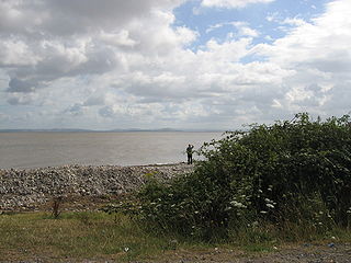
Bridgwater Bay is on the Bristol Channel, 5 kilometres (3.1 mi) north of Bridgwater in Somerset, England at the mouth of the River Parrett and the end of the River Parrett Trail. It stretches from Minehead at the southwestern end of the bay to Brean Down in the north. The area consists of large areas of mudflats, saltmarsh, sandflats and shingle ridges, some of which are vegetated. It has been designated as a Site of Special Scientific Interest (SSSI) covering an area of 3,574.1 hectares since 1989, and is designated as a wetland of international importance under the Ramsar Convention. The risks to wildlife are highlighted in the local Oil Spill Contingency Plan.

The River Aln runs through the county of Northumberland in England. It rises in Alnham in the Cheviot Hills and discharges into the North Sea at Alnmouth on the east coast of England.
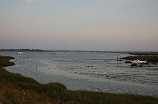
The Blackwater Estuary is the estuary of the River Blackwater between Maldon and West Mersea in Essex. It is a 5,538 hectare biological Site of Special Scientific Interest (SSSI). An area of 4,395 hectares is also designated a Ramsar Wetland of International Importance, and a Special Protection Area 1,099 hectares is a National Nature Reserve. Tollesbury Wick and part of Abbotts Hall Farm, both nature reserve managed by the Essex Wildlife Trust, are in the SSSI.
Sandbach Flashes are a group of 14 wetlands west of Sandbach in Cheshire, England. The flashes were designated as a Site of Special Scientific Interest in 1963, with a total area of 1.53 km2. There are a number of individual flashes including Bottom's Flash, Crabmill Flash, Elton Hall Flash, Fodens Flash, Groby's Flash, Ilse Pool, Moston Flashes, Pump House Flash, Railway Flash, Red Lane Tip and Pool, and Watch Lane Flash.
Alnmouth is a coastal village in Northumberland, England, situated 4 miles (6 km) east-south-east of Alnwick. The population of the civil parish at the 2001 Census was 562, reducing to 445 at the 2011 Census.

The Ribble and Alt Estuaries lie on the Irish Sea coast of the ceremonial counties of Lancashire and Merseyside in the traditional county of Lancashire in north-west England, and form the boundaries of a number of conservation schemes.

The Tamar–Tavy Estuary is a Site of Special Scientific Interest (SSSI) covering the tidal estuaries of the River Tamar and the River Tavy on the border between Cornwall and Devon in England, UK. Part of the Tamar estuary also forms the Tamar Estuary Nature Reserve, owned by the Cornwall Wildlife Trust. The site was designated in 1991 for its biodiversity and varying habitats that support many wader and wildfowl species, as well as the special interest of its marine biology.

North Devon's Biosphere Reserve is a UNESCO biosphere reserve in North Devon. It covers 55 square miles (140 km2) and is centred on Braunton Burrows, the largest sand dune system (psammosere) in England. The boundaries of the reserve follow the edges of the conjoined catchment basin of the Rivers Taw and the Torridge and stretch out to sea to include the island of Lundy. The biosphere reserve is primarily lowland farmland, and includes many protected sites including 63 Sites of Special Scientific Interest which protect habitats such as culm grassland and broadleaved woodlands. The most populous settlements in its buffer area are Barnstaple, Bideford, Northam, Ilfracombe, and Okehampton.

The North Northumberland Coastal Plain is a major natural region that lies on England's northeasternmost stretch of coastline on the North Sea. To the west lie the Cheviot Fringe, the Northumberland Sandstone Hills and Mid Northumberland; to the south it is continued by the South East Northumberland Coastal Plain.

Aber Taf is a large Site of Special Scientific Interest (SSSI) in Carmarthenshire, Wales, and forms part of the Carmarthen Bay and Estuaries Special Area of Conservation.

The history of Alnmouth, a village and sea-port in Northumberland, England, can be traced back to the Mesolithic period. Its modern history starts with the establishment of a settlement in 1152 and a charter for a port and market in 1207/8. Fragmentary evidence of occupation or use in earlier periods has been found. The port's peak period was in the 18th & 19th centuries. From the late 19th century and in the 20th century the village became a coastal resort.
Bamburgh Coast and Hills is the name given to a Site of Special Scientific Interest (SSSI) on the coast of north Northumberland, England. The site is one of the longest-standing SSSIs in England, having been listed since 1954, and displays the interaction of a fluid magma rock, now known as the Whin Sill, interacting with older sedimentary rock. Coastal erosion at the site enables sections of the geological strata to be seen. In turn, the soil associated with the Whin Sill gives rise to a distinct pattern of vegetation which on its own merits is at this site found notable.
Barrow Burn Meadows is a Site of Special Scientific Interest (SSSI) in north Northumberland, England. The site is a species-rich hay meadow of a sort now rare in Northumberland.
Barrow Meadow is a Site of Special Scientific Interest (SSSI) in north Northumberland, England. The site is a species-rich hay meadow of a sort now rare in Northumberland.
Beltingham River Shingle is the name given to a Site of Special Scientific Interest (SSSI) in Northumberland in the north-east of England, notable for an unusual community of flora tolerant to the high levels of naturally occurring heavy metals in the sediment of a section of the River South Tyne.
Brada Hill is a small hill escarpment near the coast of north Northumberland in North East England, designated as a Site of Special Scientific Interest (SSSI). The 2.4 hectares site is an outcropping of a local stone group, the Whin Sill, on which grows a range of flora representative of the thin, drought-prone soil conditions and influenced by the underlying geology.
Burnfoot River Shingle and Wydon Nabb is the name given to a Site of Special Scientific Interest (SSSI) in Northumberland, North East England. Burnfoot River Shingle is a calaminarian grassland on the River South Tyne where the local flora is influenced by high levels of naturally occurring heavy metals. Wydon Nabb is an escarpment displaying the Haltwhistle Dyke, a magmatic intrusion of igneous dolerite set amidst sedimentary sandstone and shale.

South Thames Estuary and Marshes is a 5,289-hectare (13,070-acre) biological Site of Special Scientific Interest which stretches between Gravesend and the mouth of the River Medway in Kent. Part of it is a Nature Conservation Review site, Grade I, and part is a Royal Society for the Protection of Birds nature reserve. It is part of the Thames Estuary and Marshes Ramsar internationally important wetland site and Special Protection Area under the European Union Directive on the Conservation of Wild Birds.
Milford Haven Waterway, is a Site of Special Scientific Interest (SSSI) on Milford Haven Waterway in Pembrokeshire, South Wales, designated since 2002. The site is protected for a wide range of reasons, including its geology, marine environment and ecosystems, and to protect a diversity of flora and fauna.

