
Jefferson County is an exurban county located in the U.S. state of Tennessee. As of the 2010 census, the population was 51,407. Its county seat is Dandridge. Jefferson County is part of the Morristown Metropolitan Statistical Area with neighboring Grainger and Hamblen counties. The county, along with the Morristown MSA, is included in the Knoxville-Morristown-Sevierville Combined Statistical Area.

Hamblen County is a county located in the U.S. state of Tennessee. As of the 2020 census, the population was 64,499. Its county seat and only incorporated city is Morristown. Hamblen County is the core county of the Morristown Metropolitan Statistical Area, which includes Hamblen, Jefferson, and Grainger counties. The county and the Morristown MSA is included in the Knoxville-Morristown-Sevierville, TN Combined Statistical Area.

Morristown is a city in and the county seat of Hamblen County, Tennessee, United States. Morristown also extends into Jefferson County on the western and southern ends. The population was 29,137 at the 2010 United States Census and was estimated to be 30,193 in 2019. It is the principal city of the Morristown Metropolitan Statistical Area, which encompasses all of Grainger, Hamblen, and Jefferson counties. The Morristown metropolitan area is also part of the Knoxville-Morristown-Sevierville Combined Statistical Area.

White Pine is a town in Jefferson and Hamblen counties in Tennessee, United States. It is part of the Morristown Metropolitan Statistical Area. The population was 2,196 at the 2010 census.

Bean Station is a town in Grainger and Hawkins counties in the state of Tennessee, United States. As of the 2020 census, the population was 2,967.
U.S. Route 11E is a divided highway of US 11 in the U.S. states of Tennessee and Virginia. The U.S. Highway, which is complemented by US 11W to the north and west, runs 120.9 miles (194.6 km) from US 11, US 11W, and US 70 in Knoxville, Tennessee north and east to US 11, US 11W, US 19, and US 421 in Bristol, Virginia. US 11E connects Knoxville and the twin cities of Bristol, Virginia and Bristol, Tennessee with the East Tennessee communities of Morristown, Greeneville, and Johnson City. The U.S. Highway runs concurrently with US 70 and US 25W east of Knoxville, US 321 from Greeneville and Johnson City, and both US 19W and US 19 between Johnson City and Bristol. US 11E also has an unsigned concurrency with Tennessee State Route 34 for almost all of its course in Tennessee.
U.S. Route 25E is the eastern branch of U.S. Route 25 from Newport, Tennessee, where US 25 splits into US 25E and US 25W, to North Corbin, Kentucky, where the two highways rejoin. The road, however, continues as US 25E for roughly 2 miles (3.2 km) until it joins Interstate 75 in the Laurel County community of North Corbin at exit 29. The entire route serves as a arterial expressway for long-distance travelers and truckers connecting central Appalachia to the Great Lakes and Eastern Seaboard regions of the U.S. via access to Interstate highways.
Interstate 81 (I-81) is an 855-mile-long (1,376 km) Interstate Highway stretching from Dandridge, Tennessee, northward to the Thousand Islands Bridge at the Canadian border near Fishers Landing, New York. In Tennessee, I-81 travels 75.66 miles (121.76 km) from its southern terminus at I-40 in Dandridge to the Virginia state line in Bristol. In addition, the route serves the Tri-Cities region of northeast Tennessee, but bypasses most cities that it serves, instead providing access via interchanges with state and federal routes. In Tennessee, I-81 remains in the Ridge and Valley topographic region of the Appalachian Mountains, and runs in a more northeast-southwest direction.

Russellville is a census-designated place in Hamblen County, Tennessee, United States. Located along U.S. Route 11E-Tennessee State Route 34, it is situated approximately at a midpoint between Whitesburg and Morristown.

The Knoxville metropolitan area, commonly known as Greater Knoxville, is a metropolitan statistical area centered on Knoxville, Tennessee, the third largest city in Tennessee and the largest city in East Tennessee. It is the third largest metropolitan area in Tennessee. In 2020, the metro area had a population of 879,773. The Knoxville–Morristown–Sevierville Combined Statistical Area had a population of 1,156,861 according to the census bureau in 2020.
The Morristown Metropolitan Statistical Area, commonly known as the Lakeway Area, as defined by the United States Census Bureau, is an area consisting of three counties - Grainger, Hamblen, and Jefferson - in eastern Tennessee, anchored by the city of Morristown. As of the 2000 census, the MSA had a population of 123,081. A July 1, 2009 estimate placed the population at 137,612).

Talbott is an unincorporated community in Hamblen and Jefferson counties in the U.S. state of Tennessee. In 2020, the planning commission of the city of Morristown had annexed a section of Talbott along U.S. Route 11E into its city limits.
State Route 160 is an state highway in East Tennessee that has both four-lane expressway and two-lane rural collector sections. It serves as a arterial bypass route of US 11E/SR 34 in the city of Morristown in Hamblen County.
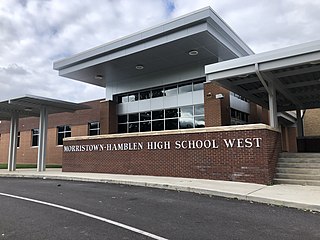
Morristown-Hamblen High School West is a secondary school located in Morristown, Tennessee. The school incorporates grades 9-12. Their mascot is the Trojan and the school colors are crimson and white. The school had an enrollment over 1,600 students as of the 2010-11 school year. Jeff Kinsler is the head principal.
Lowland is an unincorporated community in Hamblen County, Tennessee, United States.
State Route 341 is a 10.4-mile-long (16.7 km) state highway that travels within portions of Hamblen and Jefferson counties in the eastern portion of the U.S. state of Tennessee. It connects Talbott with White Pine.
State Route 343 is a state highway in Morristown, Hamblen County in the U.S. state of Tennessee. It serves as connector from US 25E into downtown Morristown.
State Route 474 was a 1.4-mile-long (2.3 km) five-lane state highway in Hamblen County in the eastern portion of the U.S. state of Tennessee. It served as a connector route from SR 160 to US 11E/SR 34. It was decommissioned and designated as part of SR 66 following a extension project by TDOT in November 2020.
The East Tennessee Crossing Byway is a 83-mile (134 km) National Scenic Byway in the U.S. state of Tennessee. Established in 2009, it is one of the newest byways in the National Scenic Byway system. The scenic byway traverses mostly along an unsigned concurrency of U.S. Route 25E/State Route 32 (US 25E/SR 32) in East Tennessee.

Witt is an unincorporated community in Hamblen County, Tennessee, United States.


