Alvordton, Ohio

Last updated
Alvordton, Ohio
CDP
Michigan at Main, Alvordton.jpg
OHMap-doton-Alvordton.png
Location of Alvordton, Ohio
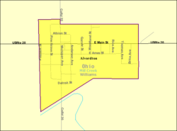
Detailed map of Alvordton.png
Detailed map of Alvordton
Coordinates: 41°39′53″N84°26′05″W / 41.66472°N 84.43472°W / 41.66472; -84.43472
Country United States
State Ohio
County Williams
Area
[1]
  Total0.25 sq mi (0.65 km2)
  Land0.25 sq mi (0.65 km2)
  Water0.00 sq mi (0.00 km2)
Elevation
[2]
853 ft (260 m)
Population
 (2020)
  Total200
  Density793.65/sq mi (306.39/km2)
Time zone UTC-5 (Eastern (EST))
  Summer (DST) UTC-4 (EDT)
ZIP code
43501
Area code 419
FIPS code 39-01588 [3]
GNIS feature ID2628857 [2]

Alvordton is a census-designated place in central Mill Creek Township, Williams County, Ohio, United States. The population was 200 at the 2020 census.

Contents

History

Alvordton post office, November 2015 Alvordton post office 43501.jpg
Alvordton post office, November 2015

Alvordton had its start when the railroad was extended to that point. [4] Alvordton was platted in 1881 by Henry D. Alvord, and named for him. [5] A post office has been in operation at Alvordton since 1881. [6] The community incorporated as a village in 1891. [5] Municipal status continued until 2007, when voters overwhelmingly approved a measure to disincorporate. [7] In 2010, the U.S. Census Bureau listed Alvordton as a census-designated place. [8]

Geography

According to the 2010 census, the CDP has a total area of 0.25 square miles (0.65 km2), all land. [9]

Demographics

Historical population
CensusPop.Note
2020 200
U.S. Decennial Census [10]

As of the census [3] of 2000, there were 305 people, 102 households, and 72 families residing in the village. The population density was 1,183.6 inhabitants per square mile (457.0/km2). There were 115 housing units at an average density of 446.3 per square mile (172.3/km2). The racial makeup of the village was 94.43% White, 1.31% African American, 0.98% Native American, 1.64% from other races, and 1.64% from two or more races. Hispanic or Latino of any race were 3.61% of the population.

There were 102 households, out of which 31.4% had children under the age of 18 living with them, 48.0% were married couples living together, 15.7% had a female householder with no husband present, and 29.4% were non-families. 23.5% of all households were made up of individuals, and 10.8% had someone living alone who was 65 years of age or older. The average household size was 2.65 and the average family size was 3.03.

In the village the population was spread out, with 25.2% under the age of 18, 9.2% from 18 to 24, 28.5% from 25 to 44, 25.2% from 45 to 64, and 11.8% who were 65 years of age or older. The median age was 36 years. For every 100 females, there were 119.4 males. For every 100 females age 18 and over, there were 121.4 males.

The median income for a household in the village was $36,250, and the median income for a family was $43,375. Males had a median income of $25,000 versus $19,205 for females. The per capita income for the village was $16,525. About 8.4% of families and 11.5% of the population were below the poverty line, including 18.1% of those under the age of eighteen and 14.7% of those sixty five or over.

Education

School-aged students in Alvordton attend school in the Millcreek-West Unity School District in nearby West Unity.

See also

Related Research Articles

<span class="mw-page-title-main">Somerville, Ohio</span> Census-designated place in Ohio, United States

Somerville is a census-designated place (CDP) and former village in Milford Township, Butler County, Ohio, United States. The population was 258 at the 2020 census.

<span class="mw-page-title-main">Castalia, Ohio</span> Village in Ohio, United States

Castalia is a village in Erie County, Ohio, United States. The population was 774 at the 2020 census. It is part of the Sandusky, Ohio Metropolitan Statistical Area.

<span class="mw-page-title-main">Addyston, Ohio</span> Village in Ohio, United States

Addyston is a village in Miami Township, Hamilton County, Ohio, United States. Located along the Ohio River, it is a western suburb of the neighboring city of Cincinnati. The population was 927 at the 2020 census.

<span class="mw-page-title-main">Cleves, Ohio</span> City in Ohio, United States

Cleves is a village in Miami Township, Hamilton County, Ohio, United States. Located along the Ohio River, it is a western suburb of Cincinnati. The population was 3,414 at the 2020 census.

<span class="mw-page-title-main">Covedale, Ohio</span> Census-designated place in Ohio, United States

Covedale is a census-designated place (CDP) in Green Township, Hamilton County, Ohio, United States. The population was 6,472 at the 2020 census. The CDP represents the part of the former village of Covedale that was not annexed by the city of Cincinnati in the 1890s.

<span class="mw-page-title-main">Evendale, Ohio</span> Village in Ohio, United States

Evendale is a village in Hamilton County, Ohio, United States, within the Cincinnati metropolitan area. The population was 2,669 at the 2020 census.

<span class="mw-page-title-main">Mariemont, Ohio</span> Village in Ohio, United States

Mariemont is a village in eastern Hamilton County, Ohio, United States. The population was 3,518 at the 2020 census. A planned community in the Cincinnati metropolitan area, it includes two overlapping historic districts, the Village of Mariemont and Mariemont Historic District. In 2007, the Village of Mariemont was designated a National Historic Landmark.

<span class="mw-page-title-main">North Bend, Ohio</span> Village in Ohio, United States

North Bend is a village in Miami Township, Hamilton County, Ohio, United States, along the Ohio River. It is a part of the Greater Cincinnati area. The population was 835 at the 2020 census.

<span class="mw-page-title-main">Greenwich, Ohio</span> Village in Ohio, United States

Greenwich is a village in Huron County, Ohio, United States. The population was 1,409 at the 2020 census. It is served by a branch of the Willard Memorial Library.

<span class="mw-page-title-main">Logan Elm Village, Ohio</span> CDP in Ohio, United States

Logan Elm Village is a census-designated place (CDP) in Pickaway County, Ohio, United States, near the site of the Logan Elm. The population was 1,062 at the 2000 census.

<span class="mw-page-title-main">Gibsonburg, Ohio</span> Village in Ohio, United States

Gibsonburg is a village in Sandusky County, Ohio, United States, about 33 miles (53 km) southeast of Toledo. The population was 2,452 at the 2020 census. The National Arbor Day Foundation has designated Gibsonburg as a Tree City USA.

<span class="mw-page-title-main">Clinton, Ohio</span> Village in Ohio, United States

Clinton is a village in southwestern Summit County, Ohio, United States. The population was 1,197 at the 2020 Census. It is part of the Akron metropolitan area.

<span class="mw-page-title-main">Blakeslee, Ohio</span> Village in Ohio, United States

Blakeslee is a village in Williams County, Ohio, United States. The population was 104 at the 2020 census.

<span class="mw-page-title-main">Edgerton, Ohio</span> Village in Ohio, United States

Edgerton is a village in Williams County, Ohio, United States in the extreme northwest corner of the state. The population was 1,881 at the 2020 census.

<span class="mw-page-title-main">Edon, Ohio</span> Village in Ohio, United States

Edon is a village in Williams County, Ohio, United States. The population was 796 at the 2020 census.

<span class="mw-page-title-main">Holiday City, Ohio</span> Village in Ohio, United States

Holiday City is a village in Williams County, Ohio, United States. The population was 48 at the 2020 census.

<span class="mw-page-title-main">West Unity, Ohio</span> Village in Ohio, United States

West Unity is a village in Williams County, Ohio, United States. The population was 1,763 at the 2020 census.

<span class="mw-page-title-main">College Corner, Ohio</span> Village in Ohio, United States

College Corner is a village in Butler and Preble counties in the southwestern part of the U.S. state of Ohio, 5 miles (8 km) northwest of Oxford. The population was 387 at the 2020 census. The village lies on the state line with Indiana, where it borders the town of West College Corner. The public school, part of the Union County–College Corner Joint School District, is bisected by the state line and is operated jointly with Indiana authorities.

<span class="mw-page-title-main">Buckeye Lake, Ohio</span> Village in Ohio, United States

Buckeye Lake is a village in Fairfield and Licking counties in the U.S. state of Ohio. The population was 2,520 at the 2020 census. It is named for Buckeye Lake, a large lake along which the village is built.

<span class="mw-page-title-main">Loveland Park, Ohio</span> Census-designated place in Ohio, United States

Loveland Park is a census-designated place (CDP) located in Symmes Township, Hamilton County and Deerfield Township, Warren County, in the southwestern part of the U.S. state of Ohio. The CDP is named after the city of Loveland. The population was 1,737 at the 2020 census.

References

  1. "ArcGIS REST Services Directory". United States Census Bureau. Retrieved September 20, 2022.
  2. 1 2 U.S. Geological Survey Geographic Names Information System: Alvordton, Ohio
  3. 1 2 "U.S. Census website". United States Census Bureau . Retrieved 2008-01-31.
  4. Bowersox, Charles A. (1920). A Standard History of Williams County, Ohio: An Authentic Narrative of the Past, with Particular Attention to the Modern Era in the Commercial, Industrial, Educational, Civic and Social Development. Lewis Publishing Company. p.  389.
  5. 1 2 Allison, Don (May 7, 2003). "Alvordton is named after its founder". The Bryan Times. p. 6. Retrieved 2 May 2015.
  6. "Williams County". Jim Forte Postal History. Retrieved 2 March 2015.
  7. Area voters OK fire levy, reject funds for schools, The Blade, 2007-08-08. Accessed 2007-09-04.
  8. U.S. Geological Survey Geographic Names Information System: Alvordton, Ohio
  9. "2010 Census U.S. Gazetteer Files for Places - Ohio". United States Census. Archived from the original on 2016-07-02. Retrieved 2012-10-13.
  10. "Census of Population and Housing". Census.gov. Retrieved June 4, 2016.

Commons-logo.svg Media related to Alvordton, Ohio at Wikimedia Commons